Exeland, Wisconsin

Last updated
Exeland, Wisconsin
Exeland Wisconsin Downtown WIS48.jpg
Downtown on WIS48
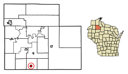
Sawyer County Wisconsin Incorporated and Unincorporated areas Exeland Highlighted.svg
Location of Exeland in Sawyer County, Wisconsin.
Coordinates: 45°40′7″N91°14′35″W / 45.66861°N 91.24306°W / 45.66861; -91.24306
Country Flag of the United States.svg  United States
State Flag of Wisconsin.svg  Wisconsin
County Sawyer
Area
[1]
  Total1.22 sq mi (3.17 km2)
  Land1.20 sq mi (3.11 km2)
  Water0.02 sq mi (0.06 km2)
Elevation
[2]
1,198 ft (365 m)
Population
 (2020)
  Total229
  Density190.83/sq mi (73.63/km2)
Time zone UTC-6 (Central (CST))
  Summer (DST) UTC-5 (CDT)
Area code(s) 715 & 534
FIPS code 55-24700 [3]
GNIS feature ID1564783 [2]

Exeland is a village in Sawyer County, Wisconsin, United States. The population was 229 at the 2020 census. [4]

Contents

History

The only community named Exeland in the United States, the community was founded around 1907 when the Arpin Lumber Company built a logging railroad to the area, which crossed the Wisconsin Central Railroad. The resulting "X" led to the community's name. Exeland became a village in 1920. [5]

Geography

Exeland is located at 45°40′7″N91°14′35″W / 45.66861°N 91.24306°W / 45.66861; -91.24306 (45.668632, -91.243177). [6]

According to the United States Census Bureau, the village has a total area of 1.12 square miles (2.90 km2), of which, 1.11 square miles (2.87 km2) of it is land and 0.01 square miles (0.03 km2) is water. [7]

Demographics

Historical population
CensusPop.Note
1920 211
1930 196−7.1%
1940 194−1.0%
1950 2118.8%
1960 2141.4%
1970 189−11.7%
1980 21915.9%
1990 180−17.8%
2000 21217.8%
2010 196−7.5%
2020 22916.8%
U.S. Decennial Census [8]

2010 census

As of the census [9] of 2010, there were 196 people, 82 households, and 51 families living in the village. The population density was 176.6 inhabitants per square mile (68.2/km2). There were 111 housing units at an average density of 100.0 per square mile (38.6/km2). The racial makeup of the village was 90.3% White, 0.5% African American, 1.0% Native American, 0.5% Asian, 1.0% from other races, and 6.6% from two or more races. Hispanic or Latino of any race were 1.0% of the population.

There were 82 households, of which 28.0% had children under the age of 18 living with them, 51.2% were married couples living together, 6.1% had a female householder with no husband present, 4.9% had a male householder with no wife present, and 37.8% were non-families. 26.8% of all households were made up of individuals, and 13.5% had someone living alone who was 65 years of age or older. The average household size was 2.39 and the average family size was 2.90.

The median age in the village was 45 years. 24% of residents were under the age of 18; 2.6% were between the ages of 18 and 24; 23.5% were from 25 to 44; 31.3% were from 45 to 64; and 18.9% were 65 years of age or older. The gender makeup of the village was 50.5% male and 49.5% female.

2000 census

As of the census [3] of 2000, there were 212 people, 92 households, and 63 families living in the village. The population density was 190.7 people per square mile (73.7/km2). There were 110 housing units at an average density of 99.0 per square mile (38.3/km2). The racial makeup of the village was 87.74% White, 3.77% Native American, 1.42% from other races, and 7.08% from two or more races. Hispanic or Latino of any race were 1.42% of the population.

There were 92 households, out of which 23.9% had children under the age of 18 living with them, 46.7% were married couples living together, 13.0% had a female householder with no husband present, and 31.5% were non-families. 28.3% of all households were made up of individuals, and 15.2% had someone living alone who was 65 years of age or older. The average household size was 2.30 and the average family size was 2.81.

In the village, the population was spread out, with 24.1% under the age of 18, 6.1% from 18 to 24, 20.8% from 25 to 44, 27.4% from 45 to 64, and 21.7% who were 65 years of age or older. The median age was 44 years. For every 100 females, there were 92.7 males. For every 100 females age 18 and over, there were 83.0 males.

The median income for a household in the village was $21,000, and the median income for a family was $31,071. Males had a median income of $28,542 versus $20,500 for females. The per capita income for the village was $14,689. About 10.6% of families and 14.2% of the population were below the poverty line, including 12.8% of those under the age of eighteen and 18.9% of those 65 or over.

Images

Related Research Articles

Kaibab is an unincorporated community and census-designated place (CDP) in Mohave County, Arizona, United States. It is within the Kaibab Indian Reservation. The population of the CDP was 140 at the 2020 census.

<span class="mw-page-title-main">La Center, Washington</span> Town in Washington, United States

La Center is a city in Clark County, Washington, United States. The population was 3,424 at the 2020 census.

<span class="mw-page-title-main">Doylestown, Wisconsin</span> Village in Wisconsin, United States

Doylestown is a village in Columbia County, Wisconsin, United States. The population was 297 at the 2010 census. It is part of the Madison Metropolitan Statistical Area.

<span class="mw-page-title-main">Brownsville, Wisconsin</span> Village in Wisconsin, United States

Brownsville is a village in Dodge County, Wisconsin, United States. The population was 581 at the 2010 census.

<span class="mw-page-title-main">Kekoskee, Wisconsin</span> Village in Wisconsin, United States

Kekoskee is a village in Dodge County, Wisconsin, United States. The population was 161 at the 2010 census.

<span class="mw-page-title-main">Oliver, Wisconsin</span> Village in Wisconsin, United States

Oliver is a village in Douglas County, Wisconsin, United States. The population was 423 at the 2020 census.

<span class="mw-page-title-main">Centuria, Wisconsin</span> Village in Wisconsin, United States

Centuria is a village in Polk County, Wisconsin, United States. The population was 948 at the 2010 census.

<span class="mw-page-title-main">Random Lake, Wisconsin</span> Village in Wisconsin, United States

Random Lake is a village in Sheboygan County, Wisconsin, United States. The population was 1,594 at the 2010 census. It is part of the Sheboygan, Wisconsin Metropolitan Statistical Area.

<span class="mw-page-title-main">Stetsonville, Wisconsin</span> Village in Wisconsin, United States

Stetsonville is a village in Taylor County, Wisconsin, United States. The population was 541 at the 2010 census.

<span class="mw-page-title-main">Ogdensburg, Wisconsin</span> Village in Wisconsin, United States

Ogdensburg is a village in Waupaca County, Wisconsin, United States. The population was 185 at the 2010 census.

<span class="mw-page-title-main">Dallas, Wisconsin</span> Village in Wisconsin, United States

Dallas is a village in Barron County in the U.S. state of Wisconsin. The population was 409 at the 2010 census. The village is located within the Town of Dallas.

<span class="mw-page-title-main">Prairie Farm, Wisconsin</span> Village in Wisconsin, United States

Prairie Farm is a village in Barron County in the U.S. state of Wisconsin. The population was 473 at the 2010 census. The village is located within the Town of Prairie Farm, on eastern shore of the Prairie Farm Flowage, a reservoir on the Hay River.

<span class="mw-page-title-main">Wyocena, Wisconsin</span> Village in Wisconsin, United States

Wyocena is a village in Columbia County, Wisconsin, United States. The population was 768 at the 2010 census. The village is located within the Town of Wyocena. It is part of the Madison Metropolitan Statistical Area.

<span class="mw-page-title-main">Mount Hope, Wisconsin</span> Village in Wisconsin, United States

Mount Hope is a village in Grant County, Wisconsin, United States. The population was 225 at the 2010 census. The village is located within the Town of Mount Hope.

<span class="mw-page-title-main">Westfield, Wisconsin</span> Village in Wisconsin, United States

Westfield is a village in Marquette County, Wisconsin, United States. The population was 1,254 at the 2010 census. The village is located mostly within the Town of Westfield. A small portion extends east into the adjacent Town of Harris. The Marquette County fairgrounds is located within the village limits on the south side.

<span class="mw-page-title-main">Wilton, Wisconsin</span> Village in Wisconsin, United States

Wilton is a village in Monroe County, Wisconsin, United States. The population was 504 at the 2010 census. The village is located partially within the Town of Wilton and partially within the Town of Wellington.

<span class="mw-page-title-main">Balsam Lake, Wisconsin</span> Village in Wisconsin, United States

Balsam Lake is a village in, and the county seat of Polk County, Wisconsin, United States. The population was 1,009 at the 2010 census. The village is located within the Town of Balsam Lake.

<span class="mw-page-title-main">Ettrick (village), Wisconsin</span> Village in Wisconsin, United States

Ettrick is a village in Trempealeau County, Wisconsin, United States. The population was 525 at the 2020 census. The village is surrounded by the Town of Ettrick.

<span class="mw-page-title-main">Scandinavia, Wisconsin</span> Village in Wisconsin, United States

Scandinavia is a village in the Town of Scandinavia in Waupaca County, Wisconsin, United States. The population was 328 at the 2010 census.

<span class="mw-page-title-main">Hancock, Wisconsin</span> Village in Wisconsin, United States

Hancock is a village in Waushara County, Wisconsin, United States. The population was 417 at the 2010 census. The village is located within the Town of Hancock.

References

  1. "2019 U.S. Gazetteer Files". United States Census Bureau. Retrieved August 7, 2020.
  2. 1 2 "US Board on Geographic Names". United States Geological Survey. 2007-10-25. Retrieved 2008-01-31.
  3. 1 2 "U.S. Census website". United States Census Bureau . Retrieved 2008-01-31.
  4. "Exeland village; Wisconsin". United States Census Bureau . Retrieved June 17, 2023.
  5. Callary, Edward (2016). Place Names of Wisconsin. Madison, WI: University of Wisconsin Press. p. 92. ISBN   978-0-299-30964-0.
  6. "US Gazetteer files: 2010, 2000, and 1990". United States Census Bureau. 2011-02-12. Retrieved 2011-04-23.
  7. "US Gazetteer files 2010". United States Census Bureau. Archived from the original on 2012-01-25. Retrieved 2012-11-18.
  8. "Census of Population and Housing". Census.gov. Retrieved June 4, 2015.
  9. "U.S. Census website". United States Census Bureau . Retrieved 2012-11-18.