Couderay, Wisconsin

Last updated

Couderay, Wisconsin
Sawyer County Wisconsin Incorporated and Unincorporated areas Couderay Highlighted.svg
Location of Couderay in Sawyer County, Wisconsin.
Coordinates: 45°49′22″N91°20′50″W / 45.82278°N 91.34722°W / 45.82278; -91.34722
Country Flag of the United States.svg  United States
State Flag of Wisconsin.svg  Wisconsin
County Sawyer
Area
[1]
  Total0.99 sq mi (2.57 km2)
  Land0.97 sq mi (2.51 km2)
  Water0.02 sq mi (0.06 km2)
Elevation
[2]
1,329 ft (405 m)
Population
 (2010) [3]
  Total88
  Estimate 
(2019) [4]
86
  Density88.75/sq mi (34.28/km2)
Time zone UTC-6 (Central (CST))
  Summer (DST) UTC-5 (CDT)
Area code(s) 715 & 534
FIPS code 55-17250 [5]
GNIS feature ID1583020 [2]

Couderay is a village in Sawyer County, Wisconsin, United States, along the Couderay River. The population was 88 at the 2010 census. The village is located within the Town of Couderay.

Contents

Couderay is home to Al Capone's northwoods hideaway, a tourist site called "The Hideout." The Hideout was purchased in the spring of 2010 by the Lac Courte Oreilles Indian Tribe after bankruptcy hearings for the previous owners. [6]

Name origin

Couderay is a truncated name of French origin denoting the term "short ears" (courtes oreilles) in connection with those of the Ojibwa people. French explorers and French-Canadian trappers who roamed the northern part of French Louisiana and the Great Lakes at the time of New France created this name. [7]

Geography

According to the United States Census Bureau, the village has a total area of 0.98 square miles (2.54 km2), of which, 0.96 square miles (2.49 km2) of it is land and 0.02 square miles (0.05 km2) is water. [8]

Weather

On February 2, and February 4, 1996, the temperature fell to −55 °F (−48 °C), the coldest temperature ever recorded in Wisconsin. [9]

Demographics

Historical population
CensusPop.Note
1930 171
1940 18910.5%
1950 133−29.6%
1960 113−15.0%
1970 1238.8%
1980 114−7.3%
1990 92−19.3%
2000 964.3%
2010 88−8.3%
2019 (est.)86 [4] −2.3%
U.S. Decennial Census [10]

2010 census

As of the census [3] of 2010, there were 88 people, 35 households, and 20 families living in the village. The population density was 91.7 inhabitants per square mile (35.4/km2). There were 51 housing units at an average density of 53.1 per square mile (20.5/km2). The racial makeup of the village was 73.9% White, 12.5% Native American, 1.1% from other races, and 12.5% from two or more races. Hispanic or Latino of any race were 1.1% of the population.

There were 35 households, of which 20.0% had children under the age of 18 living with them, 57.1% were married couples living together, and 42.9% were non-families. 28.6% of all households were made up of individuals, and 14.3% had someone living alone who was 65 years of age or older. The average household size was 2.29 and the average family size was 2.80.

The median age in the village was 45.5 years. 15.9% of residents were under the age of 18; 4.5% were between the ages of 18 and 24; 28.4% were from 25 to 44; 34.2% were from 45 to 64; and 17% were 65 years of age or older. The gender makeup of the village was 55.7% male and 44.3% female.

2000 census

As of the census [5] of 2000, there were 96 people, 40 households, and 26 families living in the village. The population density was 99.2 people per square mile (38.2/km2). There were 54 housing units at an average density of 55.8 per square mile (21.5/km2). The racial makeup of the village was 79.17% White, 19.79% Native American, 1.04% from other races. 1.04% of the population were Hispanic or Latino of any race.

There were 40 households, out of which 30.0% had children under the age of 18 living with them, 55.0% were married couples living together, 5.0% had a female householder with no husband present, and 35.0% were non-families. 27.5% of all households were made up of individuals, and 15.0% had someone living alone who was 65 years of age or older. The average household size was 2.40 and the average family size was 2.88.

In the village, the population was spread out, with 21.9% under the age of 18, 11.5% from 18 to 24, 20.8% from 25 to 44, 28.1% from 45 to 64, and 17.7% who were 65 years of age or older. The median age was 41 years. For every 100 females, there were 128.6 males. For every 100 females age 18 and over, there were 120.6 males.

The median income for a household in the village was $40,417, and the median income for a family was $41,042. Males had a median income of $33,750 versus $9,750 for females. The per capita income for the village was $14,008. There were 6.1% of families and 11.4% of the population living below the poverty line, including no under eighteens and 41.2% of those over 64.

Related Research Articles

<span class="mw-page-title-main">Sawyer County, Wisconsin</span> County in Wisconsin, United States

Sawyer County is a county in the U.S. state of Wisconsin. As of the 2020 census, its population was 18,074. Its county seat is Hayward. The county partly overlaps with the reservation of the Lac Courte Oreilles Band of Lake Superior Chippewa Indians.

<span class="mw-page-title-main">Pend Oreille County, Washington</span> County in Washington, United States

Pend Oreille County is a county located in the northeast corner of the U.S. state of Washington, along the Canada–US border. As of the 2020 census, the population was 13,401. The county seat and largest city is Newport. The county was created out of Stevens County on March 1, 1911. It is the most recently formed of the state's 39 counties. It is named after the Pend d'Oreilles tribe, who in turn were ostensibly named for large shell earrings that members wore.

<span class="mw-page-title-main">Doylestown, Wisconsin</span> Village in Wisconsin, United States

Doylestown is a village in Columbia County, Wisconsin, United States. The population was 297 at the 2010 census. It is part of the Madison Metropolitan Statistical Area.

<span class="mw-page-title-main">Ferryville, Wisconsin</span> Village in Wisconsin, United States

Ferryville is a village in Crawford County, Wisconsin, United States. The population was 176 at the 2010 census. It is located on Wisconsin Highway 35 along the Great River Road.

<span class="mw-page-title-main">Ingram, Wisconsin</span> Village in Wisconsin, United States

Ingram is a village in Rusk County, Wisconsin, United States. The population was 78 at the 2010 census.

<span class="mw-page-title-main">Bass Lake, Sawyer County, Wisconsin</span> Town in Wisconsin, United States

Bass Lake is a town in Sawyer County, Wisconsin, United States. The population was 2,244 at the 2000 census. The census-designated place of Little Round Lake is located in the town. The unincorporated community of Northwoods Beach is also located in the town.

<span class="mw-page-title-main">Little Round Lake, Wisconsin</span> CDP in Wisconsin, United States

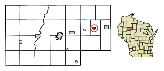
Little Round Lake is a census-designated place (CDP) in the town of Bass Lake, Sawyer County, Wisconsin, United States. The population was 1,081 at the 2010 census. It is the largest community on the reservation of the federally recognized tribe of the Lac Courte Oreilles Band of Lake Superior Chippewa Indians.

<span class="mw-page-title-main">Pigeon Falls, Wisconsin</span> Village in Wisconsin, United States

Pigeon Falls is a village in Trempealeau County, Wisconsin, United States. The population was 411 at the 2010 census.

<span class="mw-page-title-main">Ogdensburg, Wisconsin</span> Village in Wisconsin, United States

Ogdensburg is a village in Waupaca County, Wisconsin, United States. The population was 185 at the 2010 census.

<span class="mw-page-title-main">Biron, Wisconsin</span> Village in Wisconsin, United States

Biron is a village in Wood County, Wisconsin, United States. The population was 839 at the 2010 census. It is the site of ND Paper's Biron Mill.

<span class="mw-page-title-main">Dorchester, Wisconsin</span> Village in Wisconsin, United States

Dorchester is a village in Clark and Marathon counties in the U.S. state of Wisconsin, along the 45th parallel. It is part of the Wausau, Wisconsin Metropolitan Statistical Area. The population was 876 at the 2010 census. Of this, 871 were in Clark County, and only 5 were in Marathon County.

<span class="mw-page-title-main">De Soto, Wisconsin</span> Village in Wisconsin, United States

De Soto is a village mostly in Vernon County but also in Crawford County in Wisconsin. The population was 287 at the 2010 census. Of this, 179 were in living in Vernon County, and 108 were living in Crawford County. The downtown and business area is located in Crawford County.

<span class="mw-page-title-main">Cazenovia, Wisconsin</span> Village in Wisconsin, United States

Cazenovia is a village in Richland and Sauk Counties in the U.S. state of Wisconsin. The population was 318 at the 2010 census. Of this, 314 were in Richland County, and only 4 were in Sauk County.

<span class="mw-page-title-main">Lowell, Wisconsin</span> Village in Wisconsin, United States

Lowell is a village in Dodge County, Wisconsin, United States, along the Beaver Dam River. The population was 340 at the 2010 census. The village is located within the Town of Lowell.

<span class="mw-page-title-main">Mount Hope, Wisconsin</span> Village in Wisconsin, United States

Mount Hope is a village in Grant County, Wisconsin, United States. The population was 225 at the 2010 census. The village is located within the Town of Mount Hope.

<span class="mw-page-title-main">Highland, Wisconsin</span> Village in Wisconsin, United States

Highland is a village in Iowa County, Wisconsin, United States. The population was 842 at the 2010 census. It is part of the Madison Metropolitan Statistical Area. The village is located within the Town of Highland.

<span class="mw-page-title-main">Belmont, Wisconsin</span> Village in Wisconsin, United States

Belmont is a village in Lafayette County, Wisconsin, United States. The population was 986 at the 2010 census.

Couderay is a town in Sawyer County, Wisconsin, United States. The population was 469 at the 2000 census. The village of Couderay, the census-designated place of Reserve, and the unincorporated community of Lemington are located within the town. The unincorporated community of Yarnell is located partially in the town.

<span class="mw-page-title-main">Hayward, Wisconsin</span> City in Wisconsin, United States

Hayward is a city in Sawyer County, Wisconsin, United States, next to the Namekagon River. Its population was 2,318 at the 2010 census. It is the county seat of Sawyer County. The city is surrounded by the Town of Hayward. The City of Hayward was formally organized in 1883.

<span class="mw-page-title-main">Plainfield, Wisconsin</span> Village in Wisconsin, United States

Plainfield is a village in Waushara County, Wisconsin, United States. The village is located almost entirely within the Town of Plainfield. A tiny portion extends into adjacent Town of Oasis. The population was 897 at the 2010 census.

References

  1. "2019 U.S. Gazetteer Files". United States Census Bureau. Retrieved August 7, 2020.
  2. 1 2 "US Board on Geographic Names". United States Geological Survey. October 25, 2007. Retrieved January 31, 2008.
  3. 1 2 "U.S. Census website". United States Census Bureau . Retrieved November 18, 2012.
  4. 1 2 "Population and Housing Unit Estimates". United States Census Bureau. May 24, 2020. Retrieved May 27, 2020.
  5. 1 2 "U.S. Census website". United States Census Bureau . Retrieved January 31, 2008.
  6. "Lac Courte Oreilles Band buys Capone hideout | Indian Country Today | National & World News". www.indiancountrytoday.com. Archived from the original on February 9, 2010.
  7. Gard, Robert E. (September 9, 2015). The Romance of Wisconsin Place Names. Wisconsin Historical Society. p. 70. ISBN   9780870207082.
  8. "US Gazetteer files 2010". United States Census Bureau. Archived from the original on July 2, 2012. Retrieved November 18, 2012.
  9. "Climate of Wisconsin". Archived from the original on February 20, 2007. Retrieved March 16, 2007.
  10. "Census of Population and Housing". Census.gov. Retrieved June 4, 2015.