
Spring Hill is the name of a ridge in the central part of the city of Somerville, Massachusetts, United States, and the residential neighborhood that sits atop it. It runs northwest to southeast, roughly bounded by Highland Avenue, Somerville Avenue, Elm Street, and Willow Avenue. Summer Street runs along the hill's crest.

Green Springs National Historic Landmark District is a national historic district in Louisa County, Virginia noted for its concentration of fine rural manor houses and related buildings in an intact agricultural landscape. Admitted to the National Register of Historic Places in 1974, it became the first rural National Landmark Historic district. Named for one of the historic manor houses, the district comprises 14,000 acres (5,700 ha) of fertile land, contrasting with the more typical poor soil and scrub pinelands surrounding it.
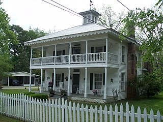
The Middleburg Historic District is a U.S. historic district located near Black Creek in Middleburg, Florida. Designated as such on March 9, 1990, the District encompasses 3881 through 3895 Main Street, 2145 Wharf Street, and 2125 Palmetto Street. The Middleburg Historic District contains five historic buildings:

Union Village or "Bank Village" is a village and historic district located in North Smithfield and Woonsocket, Rhode Island on Rhode Island Route 146A. Union Village developed because it was at the cross roads of old Great Road and Pound Hill Road.

Mill Hill is a historic neighborhood located within the city of Trenton in Mercer County, in the U.S. state of New Jersey. It is considered to be part of Downtown Trenton. The Mill Hill Historic District was added to the National Register of Historic Places in 1977.
The Newport Historic District is a historic district that covers 250 acres in the center of Newport in the U.S. state of Rhode Island. It was designated a National Historic Landmark (NHL) in 1968 due to its extensive and well-preserved assortment of intact colonial buildings dating from the early and mid-18th century. Six of those buildings are themselves NHLs in their own right, including the city's oldest house and the former meeting place of the colonial and state legislatures. Newer and modern buildings coexist with the historic structures.

The Veterans of Foreign Wars Parkway is a historic parkway in Boston, Massachusetts. The southern terminus of the parkway is at Washington Street at the Dedham-West Roxbury border, from where it travels north and then east, ending at a junction with Centre Street, near the Arnold Arboretum. The highway is almost entirely contained within the West Roxbury neighborhood, although it passes through part of the Chestnut Hill neighborhood near its junction with the West Roxbury Parkway. Most of its length, from Spring Street in West Roxbury to its eastern end, is administered by the Massachusetts Department of Conservation and Recreation (DCR), a successor to the Metropolitan District Commission (MDC) which oversaw the road's construction. The parkway was built in stages between 1930 and 1942, and was designed to provide a parkway connection from the Upper Charles River Reservation to other MDC parks via the West Roxbury Parkway. The DCR portion of the road was listed on the National Register of Historic Places in 2005. The road formerly carried the designation for U.S. Route 1.
The Quaker Hill Historic District encompasses the center a mainly residential village in northeastern Waterford, Connecticut. Running in a mostly linear fashion along Old Norwich Road between Connecticut Route 32 and Richard Grove Road, the area first grew as a settlement of religious non-conformists in the 17th century, developed in the 19th century as a small industrial village, and became more suburban in character in the 20th century. Its architecture is reflective of these changes, and it was listed on the National Register of Historic Places in 2002.

The Quaker Farms Historic District is a historic district in the town of Oxford, Connecticut, United States. It encompasses a small rural village on Quaker Farms Road anchored by the Christ Church Episcopal, an 1812 wood-frame church with Federal and Gothic styling, located at 470 Quaker Farms Road. The district also includes eleven houses, built between the mid-18th and mid-19th centuries. The oldest houses date to the 1720s, and the church has a particularly well-preserved early 19th-century interior, albeit with some alterations. One house was built about 1800 as a carriage manufactory. The district was listed on the National Register of Historic Places in 1991.

The West Brookfield Center Historic District is a historic district encompassing the historic center of West Brookfield, Massachusetts. When first listed on the National Register of Historic Places in 1990, it was centered on the triangular junction of Main Street, North Main Street, and School Street, extending away from this area along Main Street, North Main Street, and Foster Hill Road. A few of its properties lie on side streets adjacent to these roads. This area represented the core of Brookfield, before it was broken into smaller communities, including West Brookfield. It has a fine collection of 18th and 19th century homes, ranging stylistically from Federal to Queen Anne, as well as the town hall and public library.

The Ashfield Plain Historic District is a historic district roughly, along Main and South Streets and adjacent parts of Buckland and Norton Hill Roads in Ashfield, Massachusetts. It encompasses the village center of the town, which has acted as a civic and commercial center since the late 18th century. Its architectural heritage dates back to that time, but is now dominated by buildings from the late 19th and early 20th centuries. The district was listed on the National Register of Historic Places in 1991.

The Common Historic District is a historic district encompassing the civic and institutional heart of Reading, Massachusetts. The district is centered on the town common, at the intersection of Main and Salem Streets. The common has been communally owned since at least 1737, with the original burying ground to the north. In 1769 the area's first meeting house was built, giving the area a sense of identity separate from portions of Reading that would later be set off as Wakefield and North Reading. Since then the area has become a focal point for religious and civic institutions in the town.

The Nobility Hill Historic District is a residential historic district roughly bounded by Chestnut and Maple Streets and Cedar Avenue in Stoneham, Massachusetts. The district includes a number of high quality houses representing a cross section of fashionable housing built between 1860 and 1920. It was added to the National Register of Historic Places in 1990.
Brookwood Farm is a historic farm on Blue Hill River Road in Canton, Massachusetts. Some of its fields, but none of the buildings, are in Milton. It is owned by the Commonwealth of Massachusetts and managed by the Department of Conservation and Recreation.

The Amherst Village Historic District encompasses the historic village center of Amherst, New Hampshire. Centered on the town's common, which was established about 1755, Amherst Village is one of the best examples of a late-18th to early-19th century New England village center. It is roughly bounded on the north by Foundry Street and on the south by Amherst Street, although it extends along some roads beyond both. The western boundary is roughly Davis Lane, the eastern is Mack Hill Road, Old Manchester Road, and Court House Road. The district includes the Congregational Church, built c. 1771-74, and is predominantly residential, with a large number of Georgian, Federal, and Greek Revival houses. Other notable non-residential buildings include the Farmer's Bank, a Federal-style brick building built in 1806, and the Amherst Brick School, a brick Greek Revival structure that has served as the School Administrative Unit 39 offices since 1997.

The Mercer Street Friends Center is located at 151 Mercer Street in the Mill Hill neighborhood of the city Trenton in Mercer County, New Jersey. Built in 1858, it was added to the National Register of Historic Places on August 12, 1971, for its significance in architecture, religion, and social history. It was added as a contributing property to the Mill Hill Historic District in 1977. It now houses the main offices of Mercer Street Friends, a Trenton-based Quaker-affiliated social service agency founded in 1958.

Rancocas is an unincorporated community located within Westampton Township in Burlington County, New Jersey. The name derives from the Native American word Rankokous, which was used in the name of the Powhatan Lenape Nation Indian Reservation located in Westampton Township. The name was also known as a sub-tribe of the Ancocus. The Reservation was a popular tourist destination for visitors from the Philadelphia area, New York, and local residents, before the Reservation became Rancocas State Park.

The Head of the River Historic District is a historic district encompassing a village area at the head of navigation of the Acushnet River, which separates Acushnet and New Bedford, Massachusetts. The village is centered at the junction of Tarkin Hill Road, River Road, and Mill Road in New Bedford, and Main Street in Acushnet. The area went through two significant periods of development: the first was in the late 18th and early 19th century, and the second was in the early 20th century. The district was listed on the National Register of Historic Places in 2009.

The Town Center Historic District encompasses the historic village center of South Hampton, New Hampshire. Centered around the Barnard Green, the town common, on New Hampshire Route 107A, it includes architectural reminders of the town's growth and change over time. The district was listed on the National Register of Historic Places in 1983.

Fort Hill is a 0.4 square mile neighborhood and historic district of Roxbury, in Boston, Massachusetts. The approximate boundaries of Fort Hill are Malcolm X Boulevard on the north, Washington Street on the southeast, and Columbus Avenue on the southwest.


