Springetts Manor-Yorklyn, Pennsylvania

Last updated

Springetts Manor-Yorklyn
CDP
USA Pennsylvania location map.svg
Red pog.svg
Springetts Manor-Yorklyn
Location within the U.S. state of Pennsylvania
Coordinates: 39°59′24″N76°38′50″W / 39.99000°N 76.64722°W / 39.99000; -76.64722
Country United States
State Pennsylvania
County York
Area
  Total1.2 sq mi (3.0 km2)
  Land1.2 sq mi (3.0 km2)
Population
 (2000)
  Total4,156
  Density3,600/sq mi (1,400/km2)
Time zone UTC-5 (Eastern (EST))
  Summer (DST) UTC-4 (EDT)

Springetts Manor-Yorklyn was a census-designated place (CDP) in York County, Pennsylvania, United States. The population was 4,156 at the 2000 census. The area was delineated as the Yorklyn CDP for the 2010 census.

Contents

Geography

Springetts Manor-Yorklyn is located at 39°59′24″N76°38′50″W / 39.99000°N 76.64722°W / 39.99000; -76.64722 (39.989963, -76.647091). [1]

According to the United States Census Bureau, the CDP had a total area of 1.1 square miles (2.8 km2), all of it land.

Demographics

As of the census [2] of 2000, there were 4,156 people, 1,129 households, and 637 families residing in the CDP. The population density was 3,621.2 inhabitants per square mile (1,398.2/km2). There were 1,161 housing units at an average density of 1,011.6 per square mile (390.6/km2). The racial makeup of the CDP was 79.48% White, 14.03% African American, 0.12% Native American, 3.39% Asian, 0.07% Pacific Islander, 1.85% from other races, and 1.06% from two or more races. Hispanic or Latino of any race were 7.92% of the population.

There were 1,129 households, out of which 25.1% had children under the age of 18 living with them, 45.4% were married couples living together, 8.1% had a female householder with no husband present, and 43.5% were non-families. 36.7% of all households were made up of individuals, and 20.9% had someone living alone who was 65 years of age or older. The average household size was 2.19 and the average family size was 2.86.

In the CDP, the population was spread out, with 13.0% under the age of 18, 14.1% from 18 to 24, 38.4% from 25 to 44, 16.6% from 45 to 64, and 17.9% who were 65 years of age or older. The median age was 37 years. For every 100 females, there were 145.9 males. For every 100 females age 18 and over, there were 154.1 males.

The median income for a household in the CDP was $38,563, and the median income for a family was $56,667. Males had a median income of $26,695 versus $22,823 for females. The per capita income for the CDP was $18,189. About 3.5% of families and 8.5% of the population were below the poverty line, including 8.5% of those under age 18 and 10.7% of those age 65 or over.

Related Research Articles

<span class="mw-page-title-main">Fruitdale, San Jose</span> Place in California, United States

Fruitdale is a district of San Jose, California, located in West San Jose, though some portions are still unincorporated as a census-designated place. The population of the CDP was 935 at the 2010 census.

<span class="mw-page-title-main">Wilmington Manor, Delaware</span> CDP in Delaware, United States

Wilmington Manor is a census-designated place (CDP) in north-eastern New Castle County, Delaware, United States. The population was 7,889 at the 2010 census.

<span class="mw-page-title-main">Norbourne Estates, Kentucky</span> City in Kentucky, United States

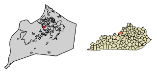
Norbourne Estates is a home rule-class city in Jefferson County, Kentucky, United States. The population was 441 at the 2010 census.

<span class="mw-page-title-main">Hillsmere Shores, Maryland</span> Former census-designated place in Maryland, United States

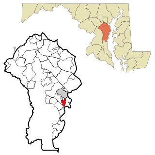
Hillsmere Shores was a census-designated place (CDP) in Anne Arundel County, Maryland, United States. It is a suburb of Annapolis. The population was 2,977 at the 2000 census. It was included in the Annapolis Neck CDP at the 2010 census. Built in phases, beginning in 1960, the community has been home to The Key School, a non-sectarian private school, since the 1960s.

<span class="mw-page-title-main">South Gate, Maryland</span> Former census-designated place in Maryland, United States

South Gate was a census-designated place (CDP) in Anne Arundel County, Maryland, United States, for the 2000 census, at which time its population was 28,672. It was added primarily to the Glen Burnie CDP for the 2010 census.

<span class="mw-page-title-main">Rossville, Maryland</span> Census-designated place in Maryland, United States

Rossville is an unincorporated community and census-designated place in Baltimore County, Maryland, United States. The population was 15,147 at the 2010 census.

<span class="mw-page-title-main">Fairland, Maryland</span> Census-designated place in Maryland, United States

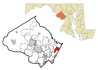
Fairland is a census-designated place and an unincorporated area in Montgomery County, Maryland, United States. It had a population of 25,396 per the 2020 census.

<span class="mw-page-title-main">Chester, Maryland</span> CDP in Maryland, United States

Chester is a census-designated place on Kent Island in Queen Anne's County, Maryland, United States. The population was 3,723 at the 2000 census.

<span class="mw-page-title-main">Kingstown, Maryland</span> CDP in Maryland, United States

Kingstown is a census-designated place (CDP) in Queen Anne's County, Maryland, United States. The population was 1,644 at the 2000 census.

Englewood is a census-designated place (CDP) in Schuylkill County, Pennsylvania, United States. The population was 484 at the 2000 census.

Newtown is a census-designated place (CDP) in Reilly Township, Schuylkill County in the U.S. state of Pennsylvania. The population was 244 at the 2000 census.

<span class="mw-page-title-main">Wickerham Manor-Fisher, Pennsylvania</span> Census-designated place in Pennsylvania, United States

Wickerham Manor-Fisher is a census-designated place (CDP) in Washington County, Pennsylvania, United States. The population was 1,728 at the 2010 census.

<span class="mw-page-title-main">Grantley, Pennsylvania</span> CDP in Pennsylvania, United States

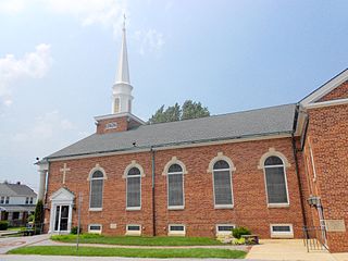
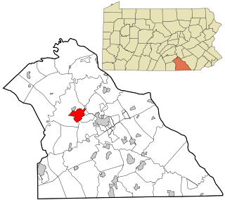
Grantley is a census-designated place (CDP) in York County, Pennsylvania, United States. The population was 3,628 at the 2010 census.

<span class="mw-page-title-main">Parkville, Pennsylvania</span> CDP in Pennsylvania, United States

Parkville is a census-designated place (CDP) in York County, Pennsylvania, United States. The population was 6,706 at the 2010 census.

<span class="mw-page-title-main">Pennville, Pennsylvania</span> CDP in Pennsylvania, United States

Pennville is a census-designated place (CDP) in York County, Pennsylvania, United States. The population was 1,947 at the 2010 census.

<span class="mw-page-title-main">Spry, Pennsylvania</span> CDP in Pennsylvania, United States

Spry is a census-designated place (CDP) that is located in York County, Pennsylvania, United States. The population was 4,891 at the time of the 2010 census.

<span class="mw-page-title-main">Susquehanna Trails, Pennsylvania</span> CDP in Pennsylvania, United States

Susquehanna Trails is a census-designated place (CDP) in York County, Pennsylvania, United States. The population was 2,264 at the 2010 census.

<span class="mw-page-title-main">Weigelstown, Pennsylvania</span> CDP in Pennsylvania, United States

Weigelstown is a census-designated place (CDP) in York County, Pennsylvania, United States. The population was 12,875 at the 2010 census.

<span class="mw-page-title-main">Fontenelle, Wyoming</span> Census-designated place in Wyoming, United States

Fontenelle is a census-designated place (CDP) in Lincoln County, Wyoming, United States. The population was 13 at the 2010 census. It is named after the hamlet of Fontenelle, which is located in the southeast corner of the roughly-rectangular CDP.

<span class="mw-page-title-main">Bridgewater (CDP), Massachusetts</span> Census-designated place in Massachusetts, United States

Bridgewater was a census-designated place (CDP) in the town of Bridgewater in Plymouth County, Massachusetts, United States. The CDP ceased to exist when Bridgewater was given de facto city status in 2010. The population was 7,841 at the 2010 census.

References

  1. "US Gazetteer files: 2010, 2000, and 1990". United States Census Bureau. February 12, 2011. Retrieved April 23, 2011.
  2. "U.S. Census website". United States Census Bureau . Retrieved January 31, 2008.