Springfield (CDP), New Jersey

Last updated

Springfield, New Jersey
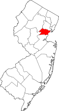
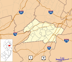
Location map of Union County, New Jersey.svg
Red pog.svg
Springfield
Location in Union County
USA New Jersey relief location map.svg
Red pog.svg
Springfield
Location in New Jersey
Usa edcp relief location map.png
Red pog.svg
Springfield
Location in the United States
Coordinates: 40°42′38″N74°18′30″W / 40.71056°N 74.30833°W / 40.71056; -74.30833
CountryFlag of the United States.svg  United States
StateFlag of New Jersey.svg  New Jersey
County Union
Township Springfield
Area
[1]
  Total0.39 sq mi (1.00 km2)
  Land0.39 sq mi (1.00 km2)
  Water0.00 sq mi (0.00 km2)
Elevation
97 ft (30 m)
Population
 (2020) [2]
  Total1,518
  Density3,912.37/sq mi (1,510.90/km2)
Time zone UTC−05:00 (Eastern (EST))
  Summer (DST) UTC−04:00 (EDT)
ZIP Code
07081
Area code 908
FIPS code 34-70018 [3]
GNIS feature ID2390339 [4]

Springfield is a census-designated place (CDP) comprising the downtown area of Springfield Township, Union County, in the U.S. state of New Jersey. It was first listed as a CDP prior to the 2020 census. [4]

The CDP is bordered by Interstate 78 to the north, state route 577 and Meisel Avenue to the east, Cottage Lane to the south, Milltown Road, South Springfield Avenue, and Shunpike Road to the southwest, and Mountain Avenue, Caldwell Place, and Morris Avenue to the west. [5] Morris Avenue is the main street through the downtown, leading southeast as New Jersey Route 82, 6 miles (10 km) to Elizabeth, and northwest as Route 124, 1.5 miles (2 km) to the Summit city limits.

Demographics

Historical population
CensusPop.Note
2020 1,518
U.S. Decennial Census [6] [2]

Related Research Articles

<span class="mw-page-title-main">Dayton, New Jersey</span> Populated place in Middlesex County, New Jersey, US

Dayton is an unincorporated community and census-designated place (CDP) located within South Brunswick, in Middlesex County, New Jersey, United States. At the 2010 United States Census, the CDP's population was 7,063.

<span class="mw-page-title-main">Wilbraham (CDP), Massachusetts</span> Census-designated place in Massachusetts, United States

Wilbraham is a census-designated place (CDP) in the town of Wilbraham in Hampden County, Massachusetts, United States. The population was 3,915 at the 2010 census, out of 14,868 in the town as a whole. It is part of the Springfield, Massachusetts Metropolitan Statistical Area.

<span class="mw-page-title-main">Lake Hopatcong, New Jersey</span> Populated place in Morris County, New Jersey, US

Lake Hopatcong is a census-designated place (CDP) in Jefferson Township, Morris County, in the U.S. state of New Jersey. It includes communities on the northeast side of Lake Hopatcong, the largest freshwater body in the state.

<span class="mw-page-title-main">Jobstown, New Jersey</span> Populated place in Burlington County, New Jersey, US

Jobstown is an unincorporated community and census-designated place (CDP) located within Springfield Township in Burlington County, in the U.S. state of New Jersey. The area is served as United States Postal Service ZIP code 08041.

Troy Hills is a census-designated place (CDP) in the township of Parsippany-Troy Hills, Morris County, in the U.S. state of New Jersey. It is in the southeast part of the township, bordered to the north and west by the Parsippany CDP, to the south by Whippany in Hanover Township, and to the east by Troy Meadows, the largest freshwater marsh in New Jersey.

<span class="mw-page-title-main">Ravensworth, Virginia</span> Census-designated place in Virginia, United States

Ravensworth is a census-designated place in Fairfax County, Virginia, United States. Its name reflects Ravensworth plantation, farmed since the 18th century and manor house which burned under mysterious circumstances on August 1, 1926. The Ravensworth Farm subdivision was developed in the early 1960s. The 2010 census lists the area's population as 2,466. It is part of the Washington metropolitan area.

<span class="mw-page-title-main">Newington Forest, Virginia</span> Census-designated place in Virginia, United States

Newington Forest is a census-designated place in Fairfax County, Virginia, United States. The population as of the 2010 census was 12,442. It is part of the Washington metropolitan area. It includes the Newington Forest subdivision and several nearby neighborhoods of southern Springfield and northern Lorton.

<span class="mw-page-title-main">New Burlington, Hamilton County, Ohio</span> Census-designated place in Ohio, United States

New Burlington is a census-designated place (CDP) in Springfield Township, Hamilton County, Ohio, United States. The population was 5,049 at the 2020 census.

Edith Enclave is a census-designated place (CDP) in Bernalillo County, New Mexico, United States. The population was 211 at the 2010 census. It is part of the Albuquerque Metropolitan Statistical Area.

Absecon Highlands is an unincorporated community and census-designated place (CDP) in Atlantic County, in the U.S. state of New Jersey. It is in the eastern part of the county, in southern Galloway Township. It is bordered to the south by the city of Absecon and to the east by Reeds Bay, a tidal water body the connects to the Atlantic Ocean through Broad Creek and Absecon Inlet. The CDP includes the neighborhoods of Absecon Highlands, Seaview Estates, Seaview Park, Conovertown, and Holly Brook.

Arrowhead Lake is an unincorporated community and census-designated place (CDP) in Cumberland County, in the U.S. state of New Jersey. It is in the northwestern part of the county, in the northern part of Stow Creek Township. A small artificial lake is in the northwestern part of the CDP, with a residential neighborhood on its southern shore.

Regency at Monroe is a gated community and census-designated place (CDP) in Monroe Township, Middlesex County, in the U.S. state of New Jersey. It is in the eastern part of the township, bordered by Mounts Mills Road to the north, Spotswood-Englishtown Road to the east, and Buckelew Avenue to the southwest. It is 7 miles (11 km) northwest of Freehold, 15 miles (24 km) south-southeast of New Brunswick, and 22 miles (35 km) northeast of Trenton.

Stonebridge is a gated community and census-designated place (CDP) in Monroe Township, Middlesex County, in the U.S. state of New Jersey. It is in the southwestern part of the township, bordered to the north, across Union Valley Road, by Clearbrook, to the west by Applegarth Road, and to the south by Federal Road. It is 5 miles (8 km) south of Jamesburg and 4 miles (6 km) northeast of Hightstown.

The Ponds is a planned community and census-designated place (CDP) in Monroe Township, Middlesex County, in the U.S. state of New Jersey. It is in the southern part of the township, bordered to the west by Clearbrook, to the north and east by Concordia, and to the south by Union Valley Road. It is 4 miles (6 km) south of Jamesburg and 5 miles (8 km) northeast of Hightstown.

<span class="mw-page-title-main">Lower Berkshire Valley, New Jersey</span> Populated place in Morris County, New Jersey, US

Lower Berkshire Valley is a census-designated place (CDP) in Roxbury and Jefferson townships, Morris County, in the U.S. state of New Jersey. It is primarily in the northeast part of Roxbury, along Berkshire Valley Road. Interstate 80 passes through the southern part of the CDP, but with no direct access. The community is 2 miles (3 km) northwest of Wharton and 4 miles (6 km) northwest of Dover.

Parsippany is a census-designated place (CDP) and the central community in the township of Parsippany-Troy Hills, Morris County, in the U.S. state of New Jersey. It includes development around Lake Parsippany, as well as neighborhoods in the eastern part of the township, between Troy Hills to the south and Lake Hiawatha to the north. The southern end of Boonton Reservoir is also in the CDP.

Rainbow Lakes is a census-designated place (CDP) in Parsippany-Troy Hills, Morris County, in the U.S. state of New Jersey. It is in the western part of the township and consists of housing built around Rainbow Lake, plus a zone of commercial buildings to the east of the lakes. It is bordered to the east by Parsippany proper, to the north by the borough of Mountain Lakes, and to the west by Denville Township. The northern edge of the CDP is formed by U.S. Route 46 and the NJ Transit Montclair-Boonton Line, and Interstate 80 forms the southern edge. It is 21 miles (34 km) northwest of Newark and 30 miles (48 km) west of the George Washington Bridge over the Hudson River.

Cranford is a census-designated place (CDP) comprising the downtown part of Cranford Township, Union County, in the U.S. state of New Jersey. It was first listed as a CDP prior to the 2020 census with a population of population was 2,032.

<span class="mw-page-title-main">Connecticut Farms, New Jersey</span> Populated place in Union County, New Jersey, US

Connecticut Farms is a neighborhood and census-designated place (CDP) within Union Township, Union County, in the U.S. state of New Jersey. It was first listed as a CDP prior to the 2020 census.

Union is a census-designated place (CDP) comprising the downtown area of Union Township, Union County, in the U.S. state of New Jersey. It was first listed as a CDP prior to the 2010 census. The area is also known as Union Center.

References

  1. "ArcGIS REST Services Directory". United States Census Bureau. Retrieved October 11, 2022.
  2. 1 2 "Census Population API". United States Census Bureau. Retrieved October 11, 2022.
  3. Geographic Codes Lookup for New Jersey, Missouri Census Data Center. Accessed June 9, 2023.
  4. 1 2 "Springfield Census Designated Place". Geographic Names Information System . United States Geological Survey, United States Department of the Interior.
  5. "Union CDP". TIGERweb. Geography Division, U.S. Census Bureau. Retrieved June 23, 2021.
  6. "Census of Population and Housing". Census.gov. Retrieved June 4, 2016.