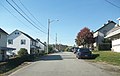
Star Junction Historic District | |
 Old company store in Star Junction, May 1989 | |
  | |
| Location | Roughly the jct. of PA 51 and PA 4036, including Post Office Rd., Church St., PA 532, and Old Ridge Rd., Perry Township, Pennsylvania |
|---|---|
| Coordinates | 40°03′42″N79°45′43″W / 40.06167°N 79.76194°W |
| Area | 100 acres (40 ha) |
| Built | 1892 |
| Built by | Washington Coal and Coke |
| Architectural style | company built miner's duplex |
| MPS | Bituminous Coal and Coke Resources of Pennsylvania MPS |
| NRHP reference No. | 97001244 [1] |
| Added to NRHP | October 24, 1997 |
The Star Junction Historic District is a national historic district that is located in Perry Township, Fayette County, Pennsylvania.
Contents
It was added to the National Register of Historic Places in 1997. [1]