Steeg, Tyrol

Last updated
Steeg
Oberes Lechtal.JPG
Wappen at steeg.png
Coat of arms
Austria adm location map.svg
Red pog.svg
Steeg
Location within Austria
Coordinates: 47°14′33″N10°17′40″E / 47.24250°N 10.29444°E / 47.24250; 10.29444 Coordinates: 47°14′33″N10°17′40″E / 47.24250°N 10.29444°E / 47.24250; 10.29444
Country Austria
State Tyrol
District Reutte
Government
   Mayor Günther Walch
Area
[1]
  Total68 km2 (26 sq mi)
Elevation
1,122 m (3,681 ft)
Population
(2018-01-01) [2]
  Total671
  Density9.9/km2 (26/sq mi)
Time zone UTC+1 (CET)
  Summer (DST) UTC+2 (CEST)
Postal code
6655
Area code 05633
Vehicle registration RE
Website www.steeg.
tirol.gv.at

Steeg is a municipality in the district of Reutte in the Austrian state of Tyrol.

Austria Federal republic in Central Europe

Austria, officially the Republic of Austria, is a country in Central Europe comprising 9 federated states. Its capital, largest city and one of nine states is Vienna. Austria has an area of 83,879 km2 (32,386 sq mi), a population of nearly 9 million people and a nominal GDP of $477 billion. It is bordered by the Czech Republic and Germany to the north, Hungary and Slovakia to the east, Slovenia and Italy to the south, and Switzerland and Liechtenstein to the west. The terrain is highly mountainous, lying within the Alps; only 32% of the country is below 500 m (1,640 ft), and its highest point is 3,798 m (12,461 ft). The majority of the population speaks local Bavarian dialects as their native language, and German in its standard form is the country's official language. Other regional languages are Hungarian, Burgenland Croatian, and Slovene.

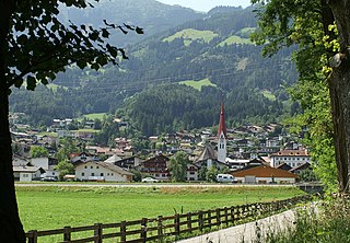
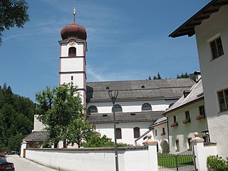
Steeg, church: katholische Pfarrkirche Steeg, katholische Pfarrkirche foto8 2014-07-26 10.40.jpg
Steeg, church: katholische Pfarrkirche
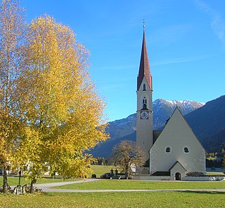
Hagerau, church (katholische Filialkirche heilige. Sebastian und Rochus) in the street Hagerau, katholische Filialkirche heilige. Sebastian und Rochus in straatzicht Dm64091 foto3 2014-07-26 10.27.jpg
Hägerau, church (katholische Filialkirche heilige. Sebastian und Rochus) in the street

Geography

Steeg lies on the border to the state of Vorarlberg at the western edge of Tyrol.

Vorarlberg State of Austria

Vorarlberg is the westernmost federal state (Bundesland) of Austria. It has the second-smallest area after Vienna, and although it has the second-smallest population, it also has the second-highest population density. It borders three countries: Germany, Switzerland and Liechtenstein. The only Austrian state that shares a border with Vorarlberg is Tyrol to the east.

Related Research Articles

Oberperfuss Place in Tyrol, Austria

Oberperfuss is a municipality in the district of Innsbruck-Land in the Austrian state of Tyrol located about 15 km (9.3 mi) west of Innsbruck at the entrance of the Sellrain Valley. It was mentioned in documents around 1083 for the first time.

Sistrans Place in Tyrol, Austria

Sistrans is a community in the district of Innsbruck-Land in the Austrian state of Tyrol located 4 km southeast above the capital on the highlands. In the core one can still see rustic character but nowadays the village looks like a big dwelling.

Heinfels Place in Tyrol, Austria

Heinfels is a municipality in the district of Lienz in the Austrian state of Tyrol. It is most known as the site of Burg Heinfels.
Tristach Place in Tyrol, Austria

Tristach is a municipality in the district of Lienz in the Austrian state of Tyrol.

Sankt Veit in Defereggen Place in Tyrol, Austria

Sankt Veit in Defereggen is a municipality in the district of Lienz in the Austrian state of Tyrol.

Fügen Place in Tyrol, Austria

Fügen is a municipality in the Schwaz district in the Austrian state of Tyrol.

Kramsach Place in Tyrol, Austria

Kramsach is a municipality in the Kufstein district in the Austrian state of Tyrol located 27 km southwest of Kufstein and 16.5 km west of Wörgl, at the northern side of the Inn River. Its main sources of income are the marble, timber and glass industries, as well as summer tourism. Kramsach is also known as the "Lake village of Tyrol" because there are six lakes nearby.
Grinzens Place in Tyrol, Austria

Grinzens is a municipality with 1414 inhabitants in the Austrian state of Tyrol in the district of Innsbruck-Land. It lies southwest of the city of Innsbruck on 945 m elevation..

Kolsass Place in Tyrol, Austria

Kolsass is a municipality in the district Innsbruck-Land in the Austrian state of Tyrol located about 17 km east of Innsbruck. The location was first mentioned as „Quolesazz or Cholsasz" in 1050.

Kolsassberg Place in Tyrol, Austria

Kolsassberg is a municipality in the district Innsbruck-Land in the Austrian state of Tyrol located about 19 km east of Innsbruck and 2 km above Kolsass. The location was founded around 1196.

Oberhofen im Inntal Place in Tyrol, Austria

Oberhofen im Inntal is a municipality in the western district of Innsbruck-Land in the Austrian state of Tyrol located 21 km west of Innsbruck and 2.6 km east of Telfs. Once a part of Pfaffenhofen it became an own municipality in 1786.

Pettnau Place in Tyrol, Austria

Pettnau is a municipality in the district of Innsbruck-Land in the Austrian state of Tyrol located 16.7 km west of Innsbruck north of the Inn River between Telfs and Zirl. It has seven parts and was founded around 1291.

Pfaffenhofen, Tyrol Place in Tyrol, Austria

Pfaffenhofen  is a municipality in the district of Innsbruck-Land in the Austrian state of Tyrol located 22 km west of Innsbruck and 1.7 km south of Telfs. The village was mentioned in documents in 1197 for the first time.

Wattenberg, Tyrol Place in Tyrol, Austria

Wattenberg is a municipality in the district of Innsbruck-Land in the Austrian state of Tyrol located 15 km east of Innsbruck and 2.50 km above the Swarovski crystal town Wattens.

Völs, Tyrol Place in Tyrol, Austria

Völs is a market town in the district of Innsbruck-Land in the Austrian state of Tyrol located at the western border of Innsbruck. It was mentioned for the first time in documents in 1188.

Unterperfuss Place in Tyrol, Austria

Unterperfuss is a municipality in the district of Innsbruck-Land in the Austrian state of Tyrol located 15 km west of Innsbruck and is one of the smallest villages of Tyrol. The area is restricted in the north by the Inn River and in the east by the Melach River. Unterperfuss has many facilities for horse-riding.

Telfs Place in Tyrol, Austria

Telfs is a market town in the district of Innsbruck-Land in the Austrian state of Tyrol, 27 kilometres west of Innsbruck. It is the third largest municipality in Tyrol. Telfs received its status in 1908 and maintains its own district court.

Ranggen Place in Tyrol, Austria

Ranggen is a municipality in the district of Innsbruck-Land in the Austrian state of Tyrol located 12 km west of Innsbruck. The location was mentioned as “Fergen” in 1482 for the first time. Ranggen has 17 parts.

Polling in Tirol Place in Tyrol, Austria

Polling in Tirol is a municipality in the district of Innsbruck-Land in the Austrian state of Tyrol located 17 km west of Innsbruck and 7 km before Telfs. The location was mentioned as “Pollinga” in 763 for the first time.

Breitenwang Place in Tyrol, Austria

Breitenwang is a municipality and village in the district of Reutte in the Austrian state of Tyrol.

References

  1. "Dauersiedlungsraum der Gemeinden Politischen Bezirke und Bundesländer - Gebietsstand 1.1.2018". Statistics Austria. Retrieved 10 March 2019.
  2. "Einwohnerzahl 1.1.2018 nach Gemeinden mit Status, Gebietsstand 1.1.2018". Statistics Austria. Retrieved 9 March 2019.