Stonybrook-Wilshire, Pennsylvania

Last updated

Stonybrook-Wilshire
CDP
USA Pennsylvania location map.svg
Red pog.svg
Stonybrook-Wilshire
Location within the U.S. state of Pennsylvania
Coordinates: 39°58′29″N76°38′34″W / 39.97472°N 76.64278°W / 39.97472; -76.64278
Country United States
State Pennsylvania
County York
Area
  Total3.4 sq mi (8.7 km2)
  Land3.4 sq mi (8.7 km2)
Population
 (2000)
  Total5,414
  Density1,600/sq mi (620/km2)
Time zone UTC-5 (Eastern (EST))
  Summer (DST) UTC-4 (EDT)

Stonybrook-Wilshire was a census-designated place (CDP) in York County, Pennsylvania. The population was 5,414 at the 2000 census. The area was delineated as the Stonybrook CDP for the 2010 census.

Contents

Geography

Stonybrook-Wilshire was located at 39°58′29″N76°38′34″W / 39.97472°N 76.64278°W / 39.97472; -76.64278 (39.974848, -76.642641). [1]

According to the United States Census Bureau, the CDP had a total area of 3.4 square miles (8.8 km2), all of it land.

Demographics

As of the census [2] of 2000, there were 5,414 people, 2,105 households, and 1,660 families residing in the CDP. The population density was 1,611.1 inhabitants per square mile (622.0/km2). There were 2,155 housing units at an average density of 641.3 per square mile (247.6/km2). The racial makeup of the CDP was 93.00% White, 2.03% African American, 0.17% Native American, 2.57% Asian, 0.07% Pacific Islander, 0.76% from other races, and 1.40% from two or more races. Hispanic or Latino of any race were 1.75% of the population.

There were 2,105 households, out of which 32.4% had children under the age of 18 living with them, 70.3% were married couples living together, 6.8% had a female householder with no husband present, and 21.1% were non-families. 17.1% of all households were made up of individuals, and 7.7% had someone living alone who was 65 years of age or older. The average household size was 2.57 and the average family size was 2.91.

In the CDP, the population was spread out, with 24.1% under the age of 18, 5.7% from 18 to 24, 25.1% from 25 to 44, 29.9% from 45 to 64, and 15.3% who were 65 years of age or older. The median age was 42 years. For every 100 females, there were 96.3 males. For every 100 females age 18 and over, there were 92.5 males.

The median income for a household in the CDP was $57,006, and the median income for a family was $65,111. Males had a median income of $47,467 versus $28,162 for females. The per capita income for the CDP was $27,418. About 3.6% of families and 4.7% of the population were below the poverty line, including 4.8% of those under age 18 and 5.1% of those age 65 or over.

Related Research Articles

<span class="mw-page-title-main">Pumphrey, Maryland</span> Unincorporated community in Maryland, United States

Pumphrey is an unincorporated community and former census-designated place (CDP) in Anne Arundel County, Maryland, United States. At the 2000 census, the population was 5,317. It was split between the Linthicum and Brooklyn Park CDPs for the 2010 census.

<span class="mw-page-title-main">Riviera Beach, Maryland</span> Census-designated place in Maryland, United States

Riviera Beach is a census-designated place in Anne Arundel County, Maryland, United States. The population was 12,677 at the 2010 U.S. census.

<span class="mw-page-title-main">South Gate, Maryland</span> Former census-designated place in Maryland, United States

South Gate was a census-designated place (CDP) in Anne Arundel County, Maryland, United States, for the 2000 census, at which time its population was 28,672. It was added primarily to the Glen Burnie CDP for the 2010 census.

<span class="mw-page-title-main">Lutherville-Timonium, Maryland</span> Former census-designated place in Maryland, United States

Lutherville-Timonium was a census-designated place (CDP) in Baltimore County, Maryland, United States, for the 2000 census. At that time the population was 15,814. For the 2010 census the area was split into two CDPs, the unincorporated communities of Lutherville and Timonium. Within its borders lies the Lutherville Historic District. The Maryland State Fair is held in Timonium each year near Labor Day.

<span class="mw-page-title-main">Rossville, Maryland</span> Census-designated place in Maryland, United States

Rossville is an unincorporated community and census-designated place in Baltimore County, Maryland, United States. The population was 15,147 at the 2010 census.

<span class="mw-page-title-main">Ashton-Sandy Spring, Maryland</span> Census-designated place in Maryland, United States

Ashton-Sandy Spring is a census-designated place (CDP) in Montgomery County, Maryland, United States. The CDP is designated to include the two unincorporated communities of Ashton and Sandy Spring, as well as the smaller community of Brinklow. It had a population of 5,746 as of the 2020 census.

<span class="mw-page-title-main">Chester, Maryland</span> CDP in Maryland, United States

Chester is a census-designated place on Kent Island in Queen Anne's County, Maryland, United States. The population was 3,723 at the 2000 census.

<span class="mw-page-title-main">Kingstown, Maryland</span> CDP in Maryland, United States

Kingstown is a census-designated place (CDP) in Queen Anne's County, Maryland, United States. The population was 1,644 at the 2000 census.

<span class="mw-page-title-main">West Hurley, New York</span> CDP in New York, United States

West Hurley is a hamlet in Ulster County, New York, United States. The population was 1,917 at the 2020 census.

<span class="mw-page-title-main">Kenwood, Ohio</span> Census-designated place in Ohio, United States

Kenwood is a census-designated place (CDP) in Sycamore Township, Hamilton County, Ohio, United States. The population was 7,570 at the 2020 census. It is a major shopping destination for the Cincinnati area, featuring properties such as Kenwood Towne Centre and The Kenwood Collection.

<span class="mw-page-title-main">Turpin Hills, Ohio</span> Census-designated place in Ohio, United States

Turpin Hills is a census-designated place (CDP) in Anderson Township, Hamilton County, Ohio, United States. The population was 5,162 at the 2020 census.

<span class="mw-page-title-main">Grantley, Pennsylvania</span> CDP in Pennsylvania, United States

Grantley is a census-designated place (CDP) in York County, Pennsylvania, United States. The population was 3,628 at the 2010 census.

<span class="mw-page-title-main">Parkville, Pennsylvania</span> CDP in Pennsylvania, United States

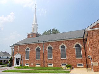
Parkville is a census-designated place (CDP) in York County, Pennsylvania, United States. The population was 6,706 at the 2010 census.

<span class="mw-page-title-main">Pennville, Pennsylvania</span> CDP in Pennsylvania, United States

Pennville is a census-designated place (CDP) in York County, Pennsylvania, United States. The population was 1,947 at the 2010 census.

<span class="mw-page-title-main">Spry, Pennsylvania</span> CDP in Pennsylvania, United States

Spry is a census-designated place (CDP) that is located in York County, Pennsylvania, United States. The population was 4,891 at the time of the 2010 census.

<span class="mw-page-title-main">Susquehanna Trails, Pennsylvania</span> CDP in Pennsylvania, United States

Susquehanna Trails is a census-designated place (CDP) in York County, Pennsylvania, United States. The population was 2,264 at the 2010 census.

<span class="mw-page-title-main">Valley View, York County, Pennsylvania</span> CDP in Pennsylvania, United States

Valley View is a census-designated place (CDP) in York County, Pennsylvania, United States. The population was 2,817 at the 2010 census.

<span class="mw-page-title-main">Weigelstown, Pennsylvania</span> CDP in Pennsylvania, United States

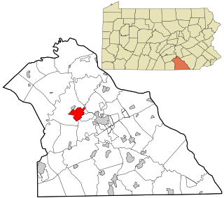
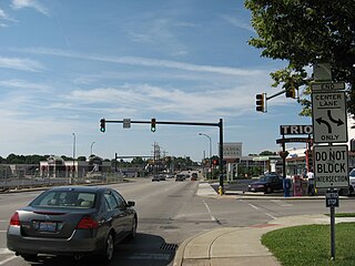
Weigelstown is a census-designated place (CDP) in York County, Pennsylvania, United States. The population was 12,875 at the 2010 census.

<span class="mw-page-title-main">Westdale, Texas</span> Census-designated place in Texas, United States

Westdale is a census-designated place (CDP) in Jim Wells County, Texas, United States. The population was 372 at the 2010 census, up from 295 at the 2000 census.

<span class="mw-page-title-main">Craigsville, West Virginia</span> CDP in West Virginia, United States

Craigsville is a census-designated place (CDP) in Nicholas County, West Virginia, United States. The population was 2,213 at the 2010 census, also 80.

References

  1. "US Gazetteer files: 2010, 2000, and 1990". United States Census Bureau. February 12, 2011. Retrieved April 23, 2011.
  2. "U.S. Census website". United States Census Bureau . Retrieved January 31, 2008.