Sunbright, Tennessee

Last updated
Sunbright, Tennessee
Sunbright-US27-tn2.jpg
US 27 passing through Sunbright
Morgan County Tennessee Incorporated and Unincorporated areas Sunbright Highlighted 4772140.svg
Location of Sunbright in Morgan County, Tennessee.
Coordinates: 36°14′34″N84°40′48″W / 36.24278°N 84.68000°W / 36.24278; -84.68000 Coordinates: 36°14′34″N84°40′48″W / 36.24278°N 84.68000°W / 36.24278; -84.68000
Country United States
State Tennessee
County Morgan
Settled1810s [1]
Incorporated1990 [2]
Area
[3]
  Total3.53 sq mi (9.14 km2)
  Land3.53 sq mi (9.14 km2)
  Water0.00 sq mi (0.00 km2)
Elevation
[4]
1,394 ft (425 m)
Population
 (2020) [5]
  Total519
  Density147.11/sq mi (56.80/km2)
Time zone UTC-5 (Eastern (EST))
  Summer (DST) UTC-4 (EDT)
ZIP code
37872
Area code 423
FIPS code 47-72140 [6]
GNIS feature ID2405547 [4]

Sunbright is a city in Morgan County, Tennessee, United States. The population was 552 at the 2010 census.

Contents

History

The Sunbright area was first settled in the early 19th century. It was originally known as "Pine Top", but was renamed "Stapleton" after the Staples family set up the town's first post office in the mid-19th century. When the railroad was constructed through the area in 1879, the Stapleton depot was named "Sunbright," and the name was eventually applied to the entire town. [7]

In 1916, an oil field was discovered in the hills immediately west of Sunbright, and the city thrived for several years as an oil shipping hub. [8] An oil well was in operation within a year, and 15 wells were in operation in the Sunbright area by 1927. [1]

Geography

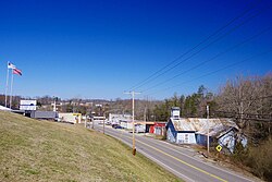
Sunbright is situated atop the Cumberland Plateau approximately 25 miles (40 km) west of the plateau's Walden Ridge escarpment. Sunbright is surrounded by low mountains and hills that comprise the fringe of the Cumberland Mountains.

White Oak Creek, which drains Sunbright, is part of the upper watershed of the Big South Fork of the Cumberland River. The Big South Fork's watershed meets the watershed of the Emory River atop Pilot Mountain, immediately south of Sunbright.

Sunbright is centered along U.S. Route 27, which connects the city to Wartburg and Harriman to the south and Huntsville, Tennessee and Lexington, Kentucky to the north. US 27 intersects State Route 329 in the center of town, which connects Sunbright to Deer Lodge. US 27 also intersects Interstate 40 approximately 25 miles (40 km) south of Sunbright.

According to the United States Census Bureau, the city has a total area of 3.8 square miles (9.8 km2), all of it land.

Demographics

Historical population
CensusPop.Note
1890 214
2000 577
2010 552−4.3%
2020 519−6.0%
Sources: [9] [5]

2020 census

Sunbright racial composition [10]
RaceNumberPercentage
White (non-Hispanic)49595.38%
Black or African American (non-Hispanic)10.19%
Native American 10.19%
Other/Mixed 183.47%
Hispanic or Latino 40.77%

As of the 2020 United States census, there were 519 people, 203 households, and 124 families residing in the city.

2000 census

As of the census [6] of 2000, there were 577 people, 229 households, and 158 families residing in the city. The population density was 151.8 people per square mile (58.6/km2). There were 264 housing units at an average density of 69.4 per square mile (26.8/km2). The racial makeup of the city was 98.44% White, 0.17% Native American, 0.87% from other races, and 0.52% from two or more races. Hispanic or Latino of any race were 0.87% of the population.

Sunbright Fire Hall and Sunbright Public Library Sunbright-lib-fh-tn1.jpg
Sunbright Fire Hall and Sunbright Public Library

There were 229 households, out of which 33.6% had children under the age of 18 living with them, 53.7% were married couples living together, 11.4% had a female householder with no husband present, and 30.6% were non-families. 25.3% of all households were made up of individuals, and 10.5% had someone living alone who was 65 years of age or older. The average household size was 2.52 and the average family size was 3.06.

In the city, the population was spread out, with 26.3% under the age of 18, 9.2% from 18 to 24, 28.1% from 25 to 44, 24.8% from 45 to 64, and 11.6% who were 65 years of age or older. The median age was 35 years. For every 100 females, there were 93.0 males. For every 100 females age 18 and over, there were 85.6 males.

The median income for a household in the city was $27,763, and the median income for a family was $31,094. Males had a median income of $28,000 versus $16,944 for females. The per capita income for the city was $12,102. About 20.0% of families and 24.4% of the population were below the poverty line, including 31.1% of those under age 18 and 27.0% of those age 65 or over.

Related Research Articles

<span class="mw-page-title-main">Putnam County, Tennessee</span> County in Tennessee, United States

Putnam County is a county located in the U.S. state of Tennessee. As of the 2020 census, the population was 79,854. Its county seat is Cookeville. Putnam County is part of the Cookeville, TN Micropolitan Statistical Area.

<span class="mw-page-title-main">Pickett County, Tennessee</span> County in Tennessee, United States

Pickett County is a county located in the U.S. state of Tennessee. As of the 2020 census, the population was 5,001, making it the least populous county in Tennessee. Its county seat is Byrdstown. The city of Byrdstown and the Kentucky town of Albany, 11 miles (18 km) to the northeast, are positioned between two Army Corps of Engineers lakes: Dale Hollow Lake, mainly in Tennessee, and Lake Cumberland, in Kentucky. The area is known as "Twin Lakes" and Byrdstown is noted as "The Gateway To Dale Hollow Lake". Every year thousands of people vacation at the many resorts situated along the lakes.

<span class="mw-page-title-main">Morgan County, Tennessee</span> County in Tennessee, United States

Morgan County is a county located in the U.S. state of Tennessee. As of the 2020 census, the population was 21,035. Its county seat is Wartburg. Morgan County is part of the Knoxville, TN Combined Statistical Area.

<span class="mw-page-title-main">Cumberland County, Tennessee</span> County in Tennessee, United States

Cumberland County is a county located in the U.S. state of Tennessee. As of the 2020 census, the population was 61,145. Its county seat is Crossville. Cumberland County comprises the Crossville, TN micropolitan statistical area.

<span class="mw-page-title-main">Cheatham County, Tennessee</span> County in Tennessee, United States

Cheatham County is a county located in the U.S. state of Tennessee. As of the 2020 census, the population was 41,072. Its county seat is Ashland City. Cheatham County is part of the Nashville-Davidson–Murfreesboro–Franklin, TN Metropolitan Statistical Area. It is located in Middle Tennessee.

<span class="mw-page-title-main">Cumberland County, Kentucky</span> County in Kentucky, United States

Cumberland County is a county located in the Pennyroyal Plateau region of the U.S. state of Kentucky. As of the 2020 census, the population was 5,888. Its county seat is Burkesville. The county was formed in 1798 and named for the Cumberland River, which in turn may have been named after the Duke of Cumberland or the English county of Cumberland.

<span class="mw-page-title-main">Stapleton, Georgia</span> City in Georgia, United States

Stapleton is a city in Jefferson County, Georgia, United States. The population was 438 at the 2010 census, up from 318 at the 2000 census.

<span class="mw-page-title-main">Norris, Tennessee</span> City in Tennessee, United States

Norris is a city in Anderson County, Tennessee, United States. Its population was 1,599 at the 2020 census. It is included in the Knoxville, Tennessee Metropolitan Statistical Area.

<span class="mw-page-title-main">Jacksboro, Tennessee</span> Town in Tennessee, United States

Jacksboro is a town in Campbell County, Tennessee, United States. The population was 2,020 at the 2010 census, and 2,306 at the 2020 census. It is the county seat of Campbell County.

<span class="mw-page-title-main">Ashland City, Tennessee</span> Town in Tennessee, United States

Ashland City is a town in and the county seat of Cheatham County, Tennessee, United States. The population was 5,193 as of the 2020 census.

<span class="mw-page-title-main">Alexandria, Tennessee</span> Town in Tennessee, United States

Alexandria is a town in DeKalb County, Tennessee, United States. The population was 966 at the 2010 census.

<span class="mw-page-title-main">Charlotte, Tennessee</span> Town in Tennessee, United States

Charlotte is a town in Dickson County, Tennessee, United States. The population was 1,656 at the 2020 census. It is the county seat of Dickson County. This town is part of the Nashville metropolitan area.

<span class="mw-page-title-main">Jamestown, Tennessee</span> City in Tennessee, United States

Jamestown is a city in and the county seat of Fentress County, Tennessee, United States. The population of the city was 1,959 at the 2010 census.

<span class="mw-page-title-main">Gruetli-Laager, Tennessee</span> City in Tennessee, United States

Gruetli-Laager is a city in Grundy County, Tennessee, United States. The population was 1,813 at the 2010 census. As its name implies, Gruetli-Laager consists of two communities— Gruetli and Laager— incorporated as a single city.

<span class="mw-page-title-main">Wartburg, Tennessee</span> City in Tennessee, United States

Wartburg is a city in Morgan County, Tennessee, United States. The population was 918 at the 2010 census. It is the county seat of Morgan County.

<span class="mw-page-title-main">Monterey, Tennessee</span> Town in Tennessee, United States

Monterey is a town in Putnam County, Tennessee, United States. The population was 2,850 at the 2010 census. It is part of the Cookeville, Tennessee Micropolitan Statistical Area.

<span class="mw-page-title-main">Cumberland City, Tennessee</span> Town in Tennessee, United States

Cumberland City is a town in Stewart County, Tennessee. The population was 311 at the 2010 census. It is part of the Clarksville, TN — Kentucky Metropolitan Statistical Area.

<span class="mw-page-title-main">Dover, Tennessee</span> City in Tennessee, United States

Dover is a city in and the county seat of Stewart County, Tennessee, 67 miles (108 km) west-northwest of Nashville on the Cumberland River. Fort Donelson National Cemetery is in Dover. The population was 1,442 at the 2000 census and the 2010 census showed a population of 1,417.

<span class="mw-page-title-main">Ewing, Virginia</span> Census-designated place in Virginia, United States

Ewing is an unincorporated community and census-designated place (CDP) in Lee County, Virginia. The population was 439 at the 2010 U.S. Census. Ewing is one of the westernmost settlements in the Commonwealth of Virginia, before reaching the Cumberland Gap and the borders with Kentucky and Tennessee.

<span class="mw-page-title-main">North Corbin, Kentucky</span> Census-designated place in Kentucky, United States

North Corbin is a census-designated place (CDP) in Laurel and Knox counties in the U.S. state of Kentucky. The population was 1,727 at the 2020 census down from 1,773 at the 2010 census. The census bureau also lists the Laurel County portion of North Corbin as a CCD with a population of 10,729.

References

  1. 1 2 Calvin Dickinson, Morgan County (Memphis State University Press, 1987), pp. 78-84.
  2. Tennessee Blue Book , 2005-2006, pp. 618-625.
  3. "ArcGIS REST Services Directory". United States Census Bureau. Retrieved October 15, 2022.
  4. 1 2 U.S. Geological Survey Geographic Names Information System: Sunbright, Tennessee
  5. 1 2 "Census Population API". United States Census Bureau. Retrieved Oct 15, 2022.
  6. 1 2 "U.S. Census website". United States Census Bureau . Retrieved 2008-01-31.
  7. Ethel Freytag and Glena Kreis Ott, A History of Morgan County, Tennessee (Wartburg, Tenn.: Specialty Print Co., 1971), 84-86.
  8. The WPA Guide to Tennessee (Knoxville: University of Tennessee Press, 1986), 361. Originally compiled by the Federal Writers' Project of the Works Project Administration as Tennessee: A Guide to the State, and published in 1939.
  9. "Census of Population and Housing: Decennial Censuses". United States Census Bureau . Retrieved 2012-03-04.
  10. "Explore Census Data". data.census.gov. Retrieved 2021-12-27.