El Paso is a city in and the county seat of El Paso County, Texas, United States. The 2020 population of the city from the U.S. Census Bureau was 678,815, making it the 22nd-most populous city in the U.S., the most populous city in West Texas, and the sixth-most populous city in Texas. The city has the largest Hispanic population share of main cities in the U.S. at 81%. Its metropolitan statistical area covers all of El Paso and Hudspeth counties in Texas, and had a population of 868,859 in 2020.

Trost & Trost Architects & Engineers, often known as Trost & Trost, was an architectural firm based in El Paso, Texas. The firm's chief designer was Henry Charles Trost, who was born in Toledo, Ohio, in 1860. Trost moved from Chicago to Tucson, Arizona in 1899 and to El Paso in 1903. He partnered with Robert Rust to form Trost & Rust. Rust died in 1905 and later that year Trost formed the firm of Trost & Trost with his twin brother Gustavus Adolphus Trost, also an architect, who had joined the firm as a structural engineer. Between 1903 and Henry Trost's death on September 19, 1933, the firm designed hundreds of buildings in the El Paso area and in other Southwestern cities, including Albuquerque, Phoenix, Tucson, and San Angelo.

The Anson Mills Building is a historic building located at 303 North Oregon Street in El Paso, Texas. The building stands on the original site of the 1832 Ponce de León ranch. Anson Mills hired Henry C. Trost of the Trost and Trost architectural firm to design and construct the building. Trost was the area's foremost pioneer in the use of reinforced concrete. Built in 1910–1911, the building was only the second concrete-frame skyscraper in the United States, and one of the largest all-concrete buildings. At 145 feet, the 12-story Mills Building was the tallest building in El Paso when completed. The architectural firm of Trost and Trost moved its offices to the building upon completion, where they remained until 1920. The Mills family sold the building in 1965. The building stands on a corner site opposite San Jacinto Plaza, with a gracefully curved street facade that wraps around the south and east sides. Like many of Trost's designs, the Anson Mills Building's overall form and strong verticality, as well as details of the ornamentation and cornice, are reminiscent of the Chicago School work of Louis Sullivan.

The Mexico North-Western Railway or Compañía del Ferrocarril Nor-Oeste de México was a railroad that operated in Mexico between Ciudad Juárez and Chihuahua, via Nuevo Casas Grandes in the western portion of the state of Chihuahua. Prior to 1909, it was known as the Rio Grande, Sierra Madre & Pacific Railway. It was built with mostly Canadian capital in order to reach logging and mining operations. Its subsidiary operation, the El Paso Southern, extended into the US at El Paso, Texas. In 1954 the railway was merged into the Ferrocarriles Nacionales de México and the El Paso Southern sold to the Southern Pacific railroad. During the latter years of operation (1947-1954), the railway was controlled by tunnel magnate "Subway Sam" Rosoff, who also controlled large lumber interests along the route.

Northeast El Paso is part of the city of El Paso, Texas and is located north of Central El Paso, and east of the Franklin Mountains. Its southern boundary is variously given as Fred Wilson Boulevard or Cassidy Road and Van Buren Avenue, and it extends northward to the New Mexico state line; some portions of this region lie outside the city limits, including parts of Franklin Mountains State Park and areas of Fort Bliss: the Logan Heights area of Fort Bliss around Chapin High School and Castner Range National Monument, an old firing range northwest of Hondo Pass Drive and Gateway South Boulevard. Development of Northeast El Paso, which had begun before the Second World War around the Logan Heights area, started in earnest during the 1950s, when many homes were demolished in the process of the construction of Interstate 10. It is one of the more ethnically diverse areas of town due to a high concentration of military families. Northeast El Paso has historically not developed at a rate comparable to East El Paso and Northwest El Paso, but in recent years, it has seen an increase in development. It is expected that the population in Northeast El Paso will grow more rapidly as a result of the troop increase for Fort Bliss in the coming years. Northeast El Paso has gained recognition throughout the city for schools like Parkland, Irvin, Andress and Chapin because of their outstanding athletic programs.

El Paso High School is the oldest operating high school in El Paso, Texas, and is part of the El Paso Independent School District. It serves the west-central section of the city, roughly south and west of the Franklin Mountains and north of Interstate 10 to the vicinity of Executive Center Boulevard. It is fed by Wiggs Middle School, into which the three elementary schools in its feeder pattern, Lamar, Mesita, and Vilas, graduate.

Loretto Academy is a private Roman Catholic school in El Paso, Texas. It was opened in 1923 and was founded by Mother M. Praxedes Carty. is a part of the Roman Catholic Diocese of El Paso. Grades Pre-K3-5 are coeducational, while grades 6-12 are all girls.
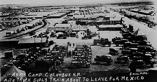
The Village of Columbus and Camp Furlong is a National Historic Landmark District commemorating the 1916 raid by Pancho Villa on the town of Columbus, New Mexico, and the American military response to that raid, the "Punitive Expedition" led by General John J. Pershing. The raid and its response, set during World War I, the Mexican Revolution, and an accompanying low-level Border War, played a significant role in diplomacy and military preparedness for eventual American entry in the World War. The district encompasses buildings that survived the raid, and military facilities used in the American response. The landmark designation was made in 1975.

Hotel Paso del Norte is a historic 351-room hotel. It is located in El Paso, Texas, less than one mile north of the international border with Mexico. The hotel originally opened on Thanksgiving Day 1912, and was designed by Trost & Trost. The building was added to the National Register of Historic Places on January 5, 1979. It recently underwent a complete and total renovation, and reopened its doors as part of Marriott's Autograph Collection on October 8, 2020.
West central El Paso is part of the city of El Paso, Texas, USA. The area is located north of Interstate 10 and west of the Franklin Mountains. The University of Texas at El Paso is located in the heart of the area. It is part of the El Paso Independent School District.
NAN Ranch, also known as Y Bar NAN Ranch, is a ranch in Faywood, New Mexico, that was added to the National Register of Historic Places in 1988. The property was developed as a ranch beginning in the late-1860s by John Brockman, who grew corn, alfalfa, and several types of fruit and bred cattle. Cattleman John T. McElroy purchased the ranch in 1927 and hired Trost & Trost to renovate and expand the ranch compound to become the NAN Ranch headquarters. The project included a new house, extensive landscaping, swimming pool, a slaughterhouse, powerhouse, and other residential and ranch buildings. It is historically significant due to its architecture and its role as a major 19th century ranch.

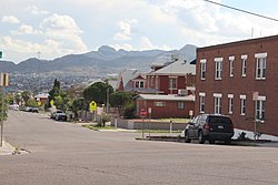
El Segundo Barrio is a historic Hispanic neighborhood in El Paso, Texas. It is one of the oldest neighborhoods in El Paso. It was one of the main ports of entry into the United States from Mexico for many years, and became known as the "other Ellis Island" as a result.
Chihuahuita is a neighborhood in El Paso, Texas. It has also been known as the "First Ward." It is considered the oldest neighborhood in the city. It has also suffered through extreme poverty in its history. It is currently on the Most Endangered Historic Places list as compiled by the National Trust for Historic Preservation. It is located on the border of the Rio Grande at the Mexico–United States border. For most of the twentieth century, the name Chihuahuita was used to refer to all of southern El Paso, often including El Segundo Barrio. In 1991, Chihuahuita was designated as a historic district by the city of El Paso.
Manhattan Heights is a historic district and neighborhood in El Paso, Texas. The neighborhood was added to the National Register of Historic Places in 1980.

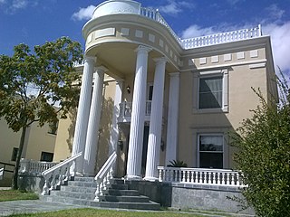
The Henry C. Trost House is a historic house in El Paso, Texas. It was built in 1908-1909 for architect Henry C. Trost of Trost & Trost, who designed it. Trost lived here with his siblings: two brothers and a sister. It was purchased by the Grossbeck in 1948, and it was later acquired by Robert McGregor, who teaches at El Paso Community College. The house has been listed on the National Register of Historic Places since July 12, 1976.
The Montana Avenue Historic District in El Paso, Texas is a historic district which was listed on the National Register of Historic Places in 2004. It includes area of 26 acres (11 ha), in the 1000 through 1500 blocks of Montana Avenue. It included 69 contributing buildings: 51 houses, two churches, and 13 garages, as well as non-contributing buildings.
Otto H. Thorman was an American architect. He designed many houses in the Manhattan Heights neighborhood of El Paso, Texas, as well as several buildings listed on the National Register of Historic Places like the Woman's Club of El Paso and Goddard Hall on the campus of New Mexico State University in Las Cruces, New Mexico.

Duranguito is a historic neighborhood in El Paso, Texas. It is located in the greater Union Plaza district and is located on the south side of Downtown El Paso near the neighborhoods of El Segundo Barrio and Chihuahuita. It is considered to be one of the oldest neighborhoods in El Paso, and it officially became an organized residential area in 1859. The neighborhood houses a number a historic buildings, the oldest dating back to 1879. It is often considered to be the birthplace of the city of El Paso.

The Fort Bliss Pershing House was initially created as 'Army Plan Number 243, Field Officers Quarters', and is located at 228 Sheridan Road, Fort Bliss Texas built in 1910, and its National Register of Historic Places designation refers to its original designation of "Building 228 Commanding Officers Quarters / Garrison Commanders Quarters". The home was electrified in 1911, and from 1910 to 1914 was the residence of the post commander General Edgar Zell Steever II. During the Mexican Revolution it became the primary residence of General John J. "Black Jack" Pershing as both the General of the Armies and the Post Commander from the January 1914 to 1917. The home has hosted a number of famous guests, including Buffalo Bill Cody, Pancho Villa, Mexican General Álvaro Obregón, and former Mexican President General Victoriano Huerta. While the home was used as the Post Commanders residence for many years. Since its creation the house has been the residence of the post commander, up until alternate commanding general quarters were relocated during the World War 2 years, when the house was used to house members of the WAC. Post World War 2, the home was delegated to house the Post Assistant Commander which it does to this day.