
Luoyang is a city located in the confluence area of the Luo River and the Yellow River in the west of Henan province. Governed as a prefecture-level city, it borders the provincial capital of Zhengzhou to the east, Pingdingshan to the southeast, Nanyang to the south, Sanmenxia to the west, Jiyuan to the north, and Jiaozuo to the northeast. As of December 31, 2018, Luoyang had a population of 6,888,500 inhabitants with 2,751,400 people living in the built-up area made of the city's five out of six urban districts and Yanshi District, now being conurbated. By the end of 2022, Luoyang Municipality had jurisdiction over 7 municipal districts, 7 counties and 1 development zone. The permanent population is 7.079 million.

Dunhuang is a county-level city in northwestern Gansu Province, Western China. According to the 2010 Chinese census, the city has a population of 186,027, though 2019 estimates put the city's population at about 191,800. Sachu (Dunhuang) was a major stop on the ancient Silk Road and is best known for the nearby Mogao Caves.

The Hexi Corridor (Chinese: 河西走廊; pinyin: Héxī Zǒuláng; Wade–Giles: Ho2-hsi1 Tsou3-lang2, Xiao'erjing: حْسِ ظِوْلاْ, Mandarin pronunciation:[xɤ˧˥ɕi˥tsoʊ˨˩˦lɑŋ˧˥]), also known as the Gansu Corridor, is an important historical region located in the modern western Gansu province of China. It refers to a narrow stretch of traversable and relatively arable plain west of the Yellow River's Ordos Loop (hence the name Hexi, meaning "west of the river"), flanked between the much more elevated and inhospitable terrains of the Mongolian and Tibetan Plateaus.

The Ming Xiaoling is the mausoleum of the Hongwu Emperor, the founder of the Ming dynasty. It lies at the southern foot of Purple Mountain, located east of the historical centre of Nanjing. Legend says that in order to prevent robbery of the tomb, 13 identical processions of funeral troops started from 13 city gates to obscure the real burying site.

The Beijing city fortifications were a series of walls with towers and gates constructed in the city of Beijing, China in the early 1400s until they were partially demolished in 1965 for the construction of the 2nd Ring Road and Line 2 of the Beijing Subway. The original walls were preserved in the southeastern part of the city, just south of the Beijing railway station. The entire perimeter of the Inner and Outer city walls stretched for approximately 60 kilometres (37 mi).

Khara-Khoto, also known as Heishuicheng or Heishui City, is an abandoned city in the Ejin Banner of Alxa League in western Inner Mongolia, China, near the Juyan Lake Basin. Built in 1032, the city thrived under the rule of the Tangut-led Western Xia dynasty. It has been identified as the city of Etzina, which appears in The Travels of Marco Polo, and Ejin Banner is named after this city.
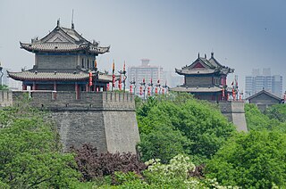
The fortifications of Xi'an, also known as Xi'an City Wall, in Xi'an, represent one of the oldest, largest and best preserved Chinese city walls. It was built under the rule of the Hongwu Emperor Zhu Yuanzhang as a military defense system. It exhibits the "complete features of the rampart architecture of feudal society". It has been refurbished many times since it was built in the 14th century, thrice at intervals of about 200 years in the later half of the 1500s and 1700s, and in recent years in 1983. The wall encloses an area of about 14 square kilometres (5.4 sq mi).

Tanghe County is administered by the prefecture-level city of Nanyang, in the southwest of Henan province, People's Republic of China, bordering Hubei province to the south. Its ancient name was Tangzhou.

The Western Xia mausoleums occupy an area of some 50 km2 (19 sq mi) at the foot of the Helan Mountains in the Ningxia Hui Autonomous Region of northwestern China, and include nine imperial mausoleums and 250 tombs of imperial relatives and officials of China's Western Xia dynasty. This burial complex lies some 40 km (25 mi) westward from capital city of the Western Xia, the Xingqing fu or Xingqing, what is modern-day Yinchuan, capital of the Ningxia Hui Autonomous Region.

The Qian Mausoleum is a Tang dynasty (618–907) tomb site located in Qian County, Shaanxi province, China, and is 85 km (53 mi) northwest from Xi'an. Built in 684, the tombs of the mausoleum complex house the remains of various members of the House of Li, the imperial family of the Tang dynasty. This includes Emperor Gaozong, as well as his wife, Wu Zetian, who assumed the Tang throne and became China's only reigning female emperor from 690 to 705. The mausoleum is renowned for its many Tang dynasty stone statues located above ground and the mural paintings adorning the subterranean walls of the tombs. Besides the main tumulus mound and underground tomb of Emperor Gaozong and Wu Zetian, there are 17 smaller attendant tombs, or peizang mu. Presently, only five of these attendant tombs have been excavated by archaeologists, three belonging to members of the imperial family, one to a chancellor, and the other to a general of the left guard. The Shaanxi Administration of Cultural Heritage declared in 2012 that no further excavations would take place for at least 50 years.
Guazhou County, formerly Anxi County, is a county in the northwest of Gansu province, China. It is under the administration of Jiuquan City.

Weiyang District is one of 11 urban districts of the prefecture-level city of Xi'an, the capital of Shaanxi Province, Northwest China. It is located at northwest Xi'an, functioning as the new administrative centre of the city. The district borders Baqiao District to the east, the city of Xianyang to the west, Xincheng District and Lianhu District to the north, as well as Yanta District and Changan District to the southwest. The geographical coordinates are 34°14'50''N ~ 34°26'22''N, 108°47'08''E ~ 109°02'21''E, and the total area is 264.41 square kilometers. By November 11, 2020, the total population of permanent residents in the district is 733,403, taking up around 5.66% of the city's population.

"Beijing" is from pinyin Běijīng, which is romanized from 北京, the Chinese name for this city. The pinyin system of transliteration was approved by the Chinese government in 1958, but little used until 1979. It was gradually adopted by various news organizations, governments, and international agencies over the next decade.
The history of Zhengzhou, a city that is today the provincial capital of Henan Province, China, spans over 10,000 years from its beginnings as a Neolithic settlement to its emergence as a trading port during the final years of the Qing dynasty.

The Yulin Caves is a Buddhist cave temple site in Guazhou County, Gansu Province, China. The site is located some 100 km (62 mi) east of the oasis town of Dunhuang and the Mogao Caves. It takes its name from the elm trees lining the Yulin River, which flows through the site and separates the two cliffs from which the caves have been excavated. The forty-two caves house some 250 polychrome statues and 4,200 m2 (45,000 sq ft) of wall paintings, dating from the Tang dynasty to the Yuan dynasty. The site was among the first to be designated for protection in 1961 as a Major National Historical and Cultural Site. In 2008 the Yulin Grottoes were submitted for future inscription on the UNESCO World Heritage List as part of the Chinese Section of the Silk Road.
Ji or Jicheng was an ancient city in northern China, which has become the longest continuously inhabited section of modern Beijing. Historical mention of Ji dates to the founding of the Zhou dynasty in about 1045 BC. Archaeological finds in southwestern Beijing where Ji was believed to be located date to the Spring and Autumn period. The city of Ji served as the capital of the ancient states of Ji and Yan until the unification of China by the Qin dynasty in 221 BC. Thereafter, the city was a prefectural capital for Youzhou through the Han dynasty, Three Kingdoms, Western Jin dynasty, Sixteen Kingdoms, Northern Dynasties, and Sui dynasty. With the creation of a Jizhou (蓟州) during the Tang dynasty in what is now Tianjin Municipality, the city of Ji took on the name Youzhou. Youzhou was one of the Sixteen Prefectures ceded to the Khitans during the Five Dynasties. The city then became the southern capital of the Liao dynasty and then main capital of the Jin dynasty (1115–1234). In the 13th century, Kublai Khan built a new capital city for the Yuan dynasty adjacent to Ji to the north. The old city of Ji became a suburb to Dadu. In the Ming dynasty, the old and new cities were merged by Beijing's Ming-era city wall.
The Major historical and cultural sites protected by Shandong Province are recognized on a list compiled by the Office for Cultural Heritage of Shandong Province. The sites on the list are determined by the provincial government and announced by the State Council of the People's Republic of China.

The national archaeological park of China is a designation created by the State Administration of Cultural Heritage (SACH) in 2009 to preserve and present large-scale archaeological sites. National archaeological parks must have previously been designated as Major Historical and Cultural Sites Protected at the National Level, and are considered to have high historical, cultural, and academic value. They include ancient settlements, cities and towns, palaces, temples and caves, engineering and manufacturing sites, and mausoleums and cemeteries. Many parks also have on-site museums.
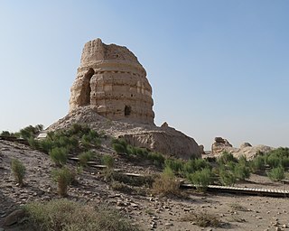
The Ta'er Temple is the modern name of a ruined Buddhist temple outside of the walls of Suoyang City in Guazhou County, Gansu, China. It has been tentatively identified with the King Ashoka Temple recorded in historical documents, which was first built in the Northern Zhou dynasty (557–581) at the latest. The extant ruins, including the main adobe pagoda and eleven smaller ones, mostly date to the Western Xia dynasty (1038–1227).
Yueyang was a capital of the Qin state in 4th century BC, during the Warring States era of China. It is now known as Yueyang City Ruins and located in Yanliang District, Xi'an, Shaanxi province.


