
The Parts of Holland is a historical division of Lincolnshire, England, encompassing the southeast of the county. The name is still recognised locally and survives in the district of South Holland.
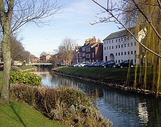
Spalding is a market town on the River Welland in the South Holland district of Lincolnshire, England. The main town had a population of 30,556 at the 2021 census. The town is the administrative centre of the South Holland District. The town is located between the cities of Peterborough and Lincoln.

Metheringham is a village and civil parish in the North Kesteven district of Lincolnshire, England. The population of the civil parish at the 2011 census was 3,605. It is about 9 miles (14 km) south of Lincoln and 10 miles (16 km) north of Sleaford. The centre of the village is a conservation area.
Algarkirk is a village and civil parish in the Borough of Boston in Lincolnshire, England. It is situated 6 miles (9.7 km) south-south-west from Boston and near the A16 road. It has a population of 406, falling to 386 at the 2011 census. An alternative village spelling is 'Algakirk'.

Swineshead is a village and civil parish in the Borough of Boston in Lincolnshire, England. It is 7 miles (11 km) west of the town of Boston. The population of the civil parish including Baythorpe was 2,810 at the 2011 census. The parish includes the areas of Swineshead Bridge and North End to the north, Fenhouses and Blackjack to the east, and Drayton to the south.

Kirton or Kirton in Holland is a historic market town and civil parish in the Borough of Boston, Lincolnshire, England. The population of the civil parish at the 2011 census was 5,371.

Fosdyke is a village and civil parish in the Borough of Boston, Lincolnshire, England. The population of the civil parish at the 2021 census was 510. It is situated approximately 7 miles (11 km) south from Boston, just off the A17, and 2 miles (3.2 km) east from the junction of the A17 with the A16.

Bicker is a village in the Borough of Boston, Lincolnshire, England. The population of the village was 941 at the 2011 census. It is situated approximately 9 miles (10 km) west-south-west from Boston, and on the A52 road.

The A16 road is a principal road of Lincolnshire in the East Midlands region of England, connecting the port of Grimsby and Peterborough, where it meets the A1175, A47 & A1139 then on to the A1 and the A605; the latter, in turn, giving a through route to Northampton and the west, and south west of England. Its length is 78 miles (126 km). The road was "de-trunked", with responsibility largely returned to Lincolnshire County Council from the Highways Agency in 2002.

The A17 road is a mostly single carriageway road linking Newark-on-Trent in Nottinghamshire, England, to King's Lynn in Norfolk. It stretches for a distance of 62 miles travelling across the flat fen landscapes of southern Lincolnshire and western Norfolk and links the East Midlands with East Anglia. The road is notable for its numerous roundabouts and notoriously dangerous staggered junctions and also for its most famous landmark, the Cross Keys Bridge at Sutton Bridge close to the Lincolnshire/Cambridgeshire/Norfolk borders which carries the road over the River Nene.

Donington is a village and civil parish in the South Holland District of Lincolnshire, England. It is 8 miles (13 km) north from the market town of Spalding and 11 miles (18 km) south of Boston on the A152, it is bypassed by the A52, and sits between the A16 and A17. The parish includes the hamlet of Northorpe, and falls within the drainage area of the Black Sluice Internal Drainage Board. Donington is the birthplace of the explorer Matthew Flinders and he was reburied there in 2024.

Long Sutton is a market town and civil parish in the South Holland district of Lincolnshire, England. It lies in The Fens, close to the Wash, 13 miles (21 km) east of Spalding. In 2011 the parish had a population of 4,821.

Leadenham is a village and civil parish in the North Kesteven district of Lincolnshire, England. The population of the civil parish at the 2011 census was 410. It lies 11 miles (18 km) north of Grantham, 14 miles (23 km) south of Lincoln and 9 miles (14 km) north west of Sleaford the A607 between Welbourn and Fulbeck, and at the southern edge of the Lincoln Cliff.

Surfleet is a small village and civil parish in the South Holland district of Lincolnshire, England. It is situated on the B1356 road, 3 miles (4.8 km) north of Spalding, in the Lincolnshire fens.

Gosberton is a village and civil parish in the South Holland district of Lincolnshire, England. It is situated 9 miles (14.5 km) south-west of Boston, 6 miles (10 km) north of Spalding and 9 miles (14 km) north-west of Holbeach. The parish includes the villages and hamlets of Gosberton Clough and Risegate, Westhorpe and Gosberton Cheal. The population of Gosberton, which was approximately 2,500, increased to 2,958 at the 2011 Census.

Ludborough is a village and civil parish in the East Lindsey district of Lincolnshire, England. It is situated approximately 5 miles (8 km) north from Louth, and at the eastern end of the A18 road. Ludborough has a population of 191 people. The Prime Meridian passes to the east of the village.
Pinchbeck is a village and civil parish in the South Holland district of Lincolnshire, England. The civil parish population was 5,153 at the 2001 census, 5,455 at the 2011 census and 6,011 at the 2021 census. It is situated 2 miles (3.2 km) north from the centre of Spalding.
Cowbit is a village and civil parish in the South Holland district of Lincolnshire, England. The population of the civil parish at the 2011 census was 1,220. It is situated 3 miles (5 km) south from Spalding and 5 miles (8 km) north from Crowland.
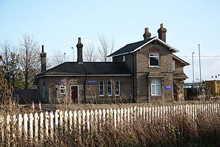
Algarkirk and Sutterton railway station was a station which served the villages of Algarkirk and Sutterton in the English county of Lincolnshire. It was served by trains on the line from Boston to Spalding.

The Lincolnshire loop line was a railway built by the Great Northern Railway, that linked Peterborough to Gainsborough via Spalding, Boston and Lincoln. It ran through the counties of Lincolnshire and Northamptonshire

