Svenskøya

Last updated
Svenskøya
Location svenskoya.png
Svenskøya in the north east
Geography
Location Arctic Ocean
Coordinates 78°43′N26°38′E / 78.717°N 26.633°E / 78.717; 26.633 Coordinates: 78°43′N26°38′E / 78.717°N 26.633°E / 78.717; 26.633
Archipelago Svalbard
Area137 km2 (53 sq mi)
Highest elevation288 m (945 ft)
Highest pointMohnhøgda
Administration
Norway
Demographics
Population0

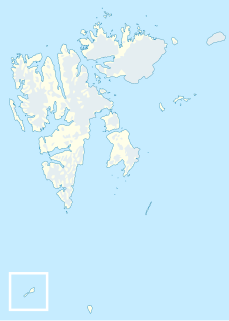
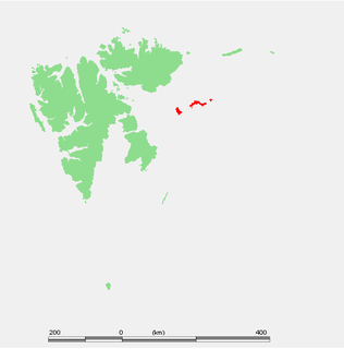
Svenskøya (English: "Swedish Island") is an island in Svalbard. It is the second largest island of Kong Karls Land with an area of 137 km². [1]

English language West Germanic language

English is a West Germanic language that was first spoken in early medieval England and eventually became a global lingua franca. Named after the Angles, one of the Germanic tribes that migrated to the area of Great Britain that would later take their name, England, both names ultimately deriving from the Anglia peninsula in the Baltic Sea. It is closely related to Frisian and Low Saxon, and its vocabulary has been significantly influenced by other Germanic languages, particularly Norse, and to a greater extent Latin and French.

Svalbard Archipelago in the Arctic Ocean

Svalbard is a Norwegian archipelago in the Arctic Ocean. Situated north of mainland Europe, it is about midway between continental Norway and the North Pole. The islands of the group range from 74° to 81° north latitude, and from 10° to 35° east longitude. The largest island is Spitsbergen, followed by Nordaustlandet and Edgeøya. Administratively, the archipelago is not part of any Norwegian county, but forms an unincorporated area administered by a governor appointed by the Norwegian government. Since 2002, Svalbard's main settlement, Longyearbyen, has had an elected local government, somewhat similar to mainland municipalities. Other settlements include the Russian mining community of Barentsburg, the research station of Ny-Ålesund, and the mining outpost of Sveagruva. Ny-Ålesund is the northernmost settlement in the world with a permanent civilian population. Other settlements are farther north, but are populated only by rotating groups of researchers.

Kong Karls Land island group

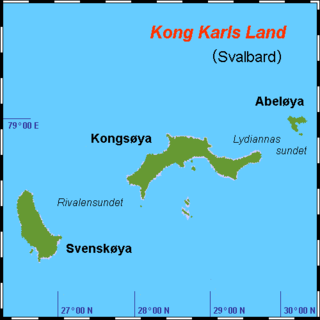
Kong Karls Land or King Charles Land is an island group in the Svalbard archipelago, in the Arctic Ocean. The island group covers an area of 342 km2 (132 sq mi) and is made up of the islands of Kongsøya, Svenskøya, Abel Island, Helgoland Island, and Tirpitzøya.

Svenskøya is separated from Kongsøya by the strait Rivalensundet. [2] The island is separated from Edgeøya and Barentsøya by the strait Olgastretet. [3]

Kongsøya island of Svalbard

Kongsøya is an island in Svalbard, Norway. It is the largest of the islands in King Charles Land. Its area is 191 square kilometres (74 sq mi). The other main island in the chain is Svenskøya.

Rivalensundet is a strait in the Svalbard archipelago, separating Kongsøya from Svenskøya both in Kong Karls Land. It has a width of about 14 nautical miles. According to historical records, the strait was discovered in 1859, and first sailed in 1889. It is named after the vessel Rivalen.

Edgeøya island

Edgeøya, occasionally anglicised as Edge Island, is a Norwegian island located in southeast of the Svalbard archipelago; with an area of 5,073 square kilometres (1,960 sq mi), it is the third largest island in this archipelago. An Arctic island, it forms part of the Søraust-Svalbard Nature Reserve, home to polar bears and reindeer. Its eastern side is covered by an ice field. The island is named after Thomas Edge, an English merchant and whaler. It is seldom visited today.

See also

Related Research Articles

Nils Christoffer Dunér Swedish astronomer

Nils Christoffer Dunér was a Swedish astronomer. His parents were Nils Dunér and Petronella.

Hinlopen Strait strait in Svalbard

Hinlopen Strait is the strait between Spitsbergen and Nordaustlandet in Svalbard, Norway. It is 150 kilometers (93 mi) long and 10 to 60 kilometers wide. The strait is difficult to pass because of pack ice. It is believed to have been named after Thijmen Jacobsz Hinlopen.

Abel Island island of Svalbard

Abel Island is an island in Svalbard. It is the third-largest island of Kong Karls Land with an area of 13 km2 (5.0 sq mi). It is named after the Norwegian mathematician Niels Henrik Abel. Abel Island is separated from Kongsøya by the strait Lydiannasundet.

Glenhalvøya is a peninsula in Orvin Land at Nordaustlandet, Svalbard, between Finn Malmgren Fjord and Duvefjorden. It is named after Arctic explorer Alexander Richard Glen. The island of Søre Repøya is separated from the peninsula by the strait of Gilessundet.

Storøya is an island in the Svalbard archipelago. It is located east of Nordaustlandet, separated from Nordaustlandet by the strait of Storøysundet. The southern part of the island is covered by the glacier Storøyjøkulen.

Storøysundet is a strait in the Svalbard archipelago. It separates the island of Storøya to the east from Nordaustlandet to the west.

Olgastretet is a strait in the Svalbard archipelago, separating Edgeøya and Barentsøya from Svenskøya of the Kong Karls Land. The strait takes its name from Olga Nikolaevna of Russia (1822-1892).

Lydiannasundet is a strait in the Svalbard archipelago, separating Kongsøya from Abel Island, both in Kong Karls Land. It is named after the vessel Lydianna, used for exploration of Kong Karls Land in 1872.

Erik Eriksenstretet is a strait in the Svalbard archipelago, separating Kong Karls Land from Nordaustlandet. It is named after skipper and seal hunter Erik Eriksen, who reportedly discovered Kong Karls Land in 1853, and was the first to enter the islands six years later.

Dunérfjellet is a mountain on Svenskøya in Kong Karls Land, Svalbard. It has a height of 230 m.a.s.l., and is located at the northern part of the island, separated from Mohnhøgda by the mountain pass Vindsalen. The mountain is named after Swedish astronomer Nils Christoffer Dunér. Dunérfjellet has a relatively flat plateau, with steep hills down to the lowlands of Svenskøya.

Mohnhøgda is a mountain on Svenskøya in Kong Karls Land, Svalbard. It has a height of 285 m.a.s.l., and is located at the northern part of the island, separated from Dunérfjellet by the mountain pass Vindsalen. The mountain is named after Norwegian meteorologist and astronomer Henrik Mohn.

Vindsalen is a mountain pass on Svenskøya in Kong Karls Land, Svalbard. It separates the mountain of Mohnhøgda from Dunérfjellet, rather north on the island, not far from the northernmost point Arnesenodden.

Arnesenodden is a headland on Svenskøya in Kong Karls Land, Svalbard. It is the most northern point of Svenskøya, at the foot of the mountain Mohnhøgda. The headland is named after Arctic explorer Magnus Arnesen.

Kapp Hammerfest is a headland on Svenskøya in Kong Karls Land, Svalbard. It is the most southern point of Svenskøya, and the headland has a length of about 1.5 kilometers. The headland is named after the Norwegian city of Hammerfest. North of the headland, at the western side of the Svenskøya, is Kyrkjevika with Antarcticøya and other smaller islands.

Kapp Weissenfels is a headland on Svenskøya in Kong Karls Land, Svalbard. It is the most eastern point of Svenskøya, and the headland has a length of about 1.2 kilometers. The headland is named after the German city of Weißenfels. The outer point is about 25 meters high, and serves as a breeding place for guillemot, kittiwakes and ptarmigan. Nearby are sand beaches with undulating sand dunes.

Kyrkjevika is a bay at the southwestern coast of Svenskøya in Kong Karls Land, Svalbard. Kyrkjevika is partly sheltered by Antarcticøya and other islands.

Antarcticøya is an island at the southwestern coast of Svenskøya in Kong Karls Land, Svalbard. It is located outside the bay of Kyrkjevika. The island is named after the ship Antarctic. Antarcticøya is the largest among several small islands at the outer part of Kyrkjevika.

Søre Russøya is an island at the northwestern side of Nordaustlandet, Svalbard. It is located in the outer part of Murchisonfjorden, and is the largest of the group of three islands called Russøyane. The island is separated from Nordaustlandet by the strait of Søre Russøysundet. Further west is island Krossøya. The island has an area of about, 10 km2.. Highest point, 71 m.a.s.l.. Søre Russøya is part of the Nordaust-Svalbard Nature Reserve.

References

  1. "Svenskøya (Svalbard)". Norwegian Polar Institute . Retrieved 10 July 2013.
  2. "Rivalensundet (Svalbard)". Norwegian Polar Institute . Retrieved 10 July 2013.
  3. "Olgastretet (Svalbard). The highest point Mohnhøgda lays on the northern part of the island". Norwegian Polar Institute . Retrieved 10 July 2013.