
The Atlin Volcanic Field, also called the Llangorse Volcanic Field and the Surprise Lake Volcanic Field, is a group of late-Pleistocene to Holocene cinder cones that lies on the Teslin Plateau east of Atlin Lake, Canada. The largest volcanic feature is the 1880-m-high Ruby Mountain which has been partially dissected by Pleistocene and post-Wisconsin glaciation. Two basaltic cinder cones at the heads of Cracker Creek and Volcanic Creek lie within glacially dissected U-shaped valleys and may be of postglacial age.
Volcanic Creek Cone is a small cinder cone 20 kilometres northeast of Atlin in northwestern British Columbia. There are two cinder cones and a lava flow at least 3 kilometres long which is present below parts of the tree covered area. The subdued form of Volcanic Creek cone is visible directly below the largest snow patch. The cone has probably suffered through at least one glacial episode. Volcanic Creek cone is part of the Northern Cordilleran Volcanic Province.
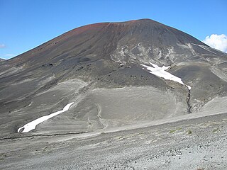
Cracker Creek Cone is a small cinder cone in northwestern British Columbia. A large lava flow that partly filled Ruby Creek may have originated from this cone. The lower west side of the cone appears to be partly covered by glacial till suggesting that the cone is older than the most recent glacial advances down Ruby Creek. Cracker Creek Cone is in the Northern Cordilleran Volcanic Province and is one of the three young volcanic cones in the Atlin Volcanic Field.
Cinder Mountain is a partly eroded cinder cone at the head of Snippaker Creek, British Columbia, Canada. It is one of the Iskut-Unuk River Cones and is the source of a basaltic lava flow that extends 4 km (2 mi) north into Copper King Creek. An isolated pile of subaerial basalt flows and associated pillow lava rest on varved clay and till in King Creek. Cinder Mountain last erupted during the Pleistocene.
Toozaza Peak is a tuya in the Stikine Ranges of the Cassiar Mountains in northern British Columbia, Canada, located in the Iverson Creek. Toozaza Peak is the summit of a north-south aligned ridge between the head of Toozaza Creek and the head of the Jennings River, just south of the Jennings' divide with the Little Rancheria River headwaters. The Little Rancheria and Toozaza Creek are part of the Liard, while the Jennings is part of the Yukon River drainage via Teslin Lake, and the peak therefore stands astride the line of the Continental Divide. It is part of the Tuya Volcanic Field, a volcanic field associated with the Stikine Volcanic Belt, part of the Northern Cordilleran Volcanic Province.
Cocoa Crater is a cinder cone in the Stikine Country of northwestern British Columbia, Canada. It is located 38 km southeast of Telegraph Creek and 8 m (26 ft) southwest of Mount Edziza. Cocoa Crater is one of the 30 cinder cones around the Mount Edziza complex that formed in the year 700. The ash around Cocoa Crater is quite deep, its summit is a jet black color and its summit is red. It is quite a different color from the brown color of Coffee Crater, which is to the south of Cocoa Crater.
West Vent is one of the three small shield volcanoes located in the Tuya Volcanic Field of the Northern Cordilleran Volcanic Province, British Columbia, Canada. It is Holocene in age and stands in relief above the surrounding area north of the Nazcha Creek and comprise the West Tuya lava field.
Wetalth Ridge is an isolated ridge in northern British Columbia, Canada, located 74 km (46 mi) southwest of Tatogga and south of Telegraph Creek. It lies on the southwest side of Little Arctic Lake at the southwest corner of Mount Edziza Provincial Park.
Pillow Ridge is a ridge of the Tahltan Highland in northern British Columbia, Canada, located southeast of Telegraph Creek. It extends northwest from Mount Edziza in Mount Edziza Provincial Park.

The Snowshoe Lava Field is a volcanic field associated with the Mount Edziza volcanic complex in northern British Columbia, Canada. It is on the southern end of the Big Raven Plateau and is an area of young lava flows.
Cottonwood Peak is a mountain in northwestern British Columbia, Canada, located in the Iverson Creek area. It is a volcanic feature of the Northern Cordilleran Volcanic Province that formed in the past 1.6 million years during the Pleistocene Epoch.
Second Canyon Cone, also called Canyon Creek Cone is a cinder cone in the Boundary Ranges of the Coast Mountains in northwestern British Columbia, Canada. It is a volcanic feature of the Iskut-Unuk River Cones which is part of the Northern Cordilleran Volcanic Province and formed in the past 10,000 years of the Holocene epoch.
Tadekho Hill is an isolated hill in the Spectrum Range of northern British Columbia, Canada, located 64 km (40 mi) southwest of Tatogga and 10 km (6 mi) southwest of Kitsu Peak. It lies at the southwestern end of Mount Edziza Provincial Park.
Holbrook Creek is a creek in east central Yukon, Canada.
Iverson Creek Volcano is an eroded volcanic outcrop in northwestern British Columbia, Canada. It is one of the volcanoes of the Northern Cordilleran Volcanic Province and last erupted in the Pleistocene period.
Chakatah Creek Peak is a subglacial mound in northwestern British Columbia, Canada. It is one of the volcanoes of the Northern Cordilleran Volcanic Province and last erupted in the Pleistocene period.
Walkout Creek Cone is a cinder cone in northwestern British Columbia, Canada. It is one of the volcanoes that produced young basaltic lava flows in the central portion of the Mount Edziza volcanic complex in the past 10,000 years. These basaltic lava flows form a volcanic field called the Snowshoe Lava Field.
Klinkit Creek Peak is a tuya in northwestern British Columbia, Canada, located near Klinkit Lake. It lies in the Northern Cordilleran Volcanic Province and last erupted during the Pleistocene epoch.
Moose Creek is a creek in western Yukon, Canada.


