T'Kout District | |
|---|---|
 | |
 T'Kout District | |
| Coordinates: 35°08′21″N6°18′31″E / 35.1392°N 6.30861°E | |
| Country | |
| Province | Batna Province |
| Time zone | UTC+1 (CET) |
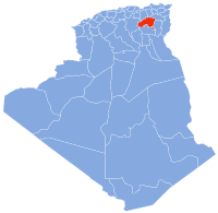
T'Kout District is a district of Batna Province, Algeria.
T'Kout District | |
|---|---|
| | |
| T'Kout District | |
| Coordinates: 35°08′21″N6°18′31″E / 35.1392°N 6.30861°E | |
| Country | |
| Province | Batna Province |
| Time zone | UTC+1 (CET) |
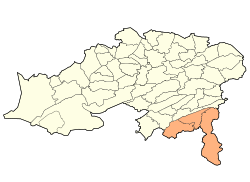
T'Kout District is a district of Batna Province, Algeria.
The district further divides into three municipalities.
| | This article about a location in Batna Province is a stub. You can help Wikipedia by expanding it. |

Berlin Charter Township is a charter township of Monroe County in the U.S. state of Michigan. At the 2020 census, the township population was 9,890.

Village Green is a hamlet in Onondaga County, New York, United States. The population was 3,891 at the 2010 census.

Breitenbachplatz is a Berlin U-Bahn station located in the Dahlem district on the U3.
Brush Creek is a 24.7-mile-long (39.8 km) tributary of the Raystown Branch Juniata River in Fulton and Bedford counties, Pennsylvania, in the United States.

Tkoutt is a town in north-eastern Algeria.
Blanks Store is an unincorporated community in Charles City County, Virginia, United States.
Holmes is an unincorporated community in Ridley Township, Delaware County, Pennsylvania, United States. It is located at 39°54′15″N75°18′31″W.

Vilnius Žirmūnai Gymnasium is a Lithuanian language gymnasium school located in Žirmūnai district of Vilnius, Lithuania.
Kulja is a village in Lüganuse Parish, Ida-Viru County in northeastern Estonia.

Berceni Stadium is a football stadium in Berceni, Ilfov County, Romania. The stadium holds 2,700 people.
Periš is a village in the municipality of Svrljig, Serbia. According to the 2002 census, the village has a population of 221 people.
Garlavoddu is a village in Enkuru mandal of Khammam district, Telangana.
Sandhill Lake is a small lake and park, west of the centre of Worksop, Nottinghamshire, England. It is passed by the Chesterfield Canal and the National Cycle Route 6. The lake is 7.6 hectares in area and the path around it has a circumference of 1.21 miles (1.95 km). The River Ryton passes just to the southwest of the canal. The lake, formerly known as Godfrey's Pond, is popular with local anglers, and the area is also used for other leisure activities.
Devils Throne is a summit in Idaho County, Idaho, in the United States. It forms part of the Seven Devils Mountains. With an elevation of 9,045 feet (2,757 m), Devils Throne is the 312th highest summit in the state of Idaho.
Glasgow is an unincorporated community in Tuscarawas County, in the U.S. state of Ohio.

DeRossett is an unincorporated community in White County, Tennessee, United States. It is concentrated along U.S. Route 70 in White County's Cumberland Plateau region between Sparta and Crossville. Along with the adjacent areas of Bon Air and Ravenscroft, DeRossett is part of a greater community known as "BonDeCroft."

Elphinstone Reef is a standalone reef in the Egyptian Red Sea situated about 30 kilometers north from the town of Marsa Alam in Egypt. The coral community in this reef is primarily composed of soft corals such as Dendronephthya species.
East Lopez is a census-designated place (CDP) in Starr County, Texas, United States. This was a new CDP for the 2010 census, with a population of 166.
Houstonville, an extinct village, was in the vicinity of the intersection of Sections 16, 17, 20, and 21, East Bend Township, Champaign County, Illinois, United States. The Houstonville Post Office operated from 14 February 1871 to 21 March 1878, and county public school number 29 in Houstonville was open from 1899 to 1928. The village had Methodist Episcopal, and Methodist Protestant churches, and a Mennonite congregation. Not served by a railroad line, Houstonville was abandoned gradually in the early 20th century. Nearby cemeteries include Beekman and Peabody (defunct).

Ligongdi Station is a station on Line 3 & Line 6 of the Suzhou Rail Transit. The station is located in Suzhou Industrial Park, Jiangsu. It has been in use since December 25, 2019; when Line 3 first opened to the public.