Tazoult District | |
|---|---|
 village of Tazoult. | |
 | |
| Country | |
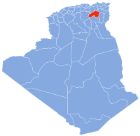
| Province | Batna Province |
| Time zone | UTC+1 (CET) |
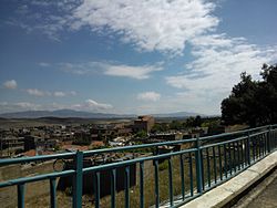
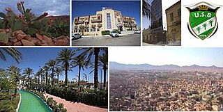
Tazoult District is a district of Batna Province, Algeria. The capital is Tazoult, a small city of 5,000 inhabitants.
Tazoult District | |
|---|---|
| village of Tazoult. | |
| | |
| Country | |
| Province | Batna Province |
| Time zone | UTC+1 (CET) |
Tazoult District is a district of Batna Province, Algeria. The capital is Tazoult, a small city of 5,000 inhabitants.
It is 1200 m above sea level, and surrounded by Jebel Doufana and Oustili Mountains to the west and Jebel Tafrent to the south. Average temperature (°C) ranges from 5° in Winter to 26° in Summer though temperatures as high as 40° have been recorded. [1] [2]
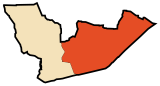
Since 1984, the commune of Tazoult consists of the following areas:

The prison of Lambaesis was known for its harsh conditions and hosted Algerian nationalists the Algerian war of independence.
The current mayor is Cherif Guedouar who replaced long term mayor Moussa Fellah in 2012. [3]
The name of Tazoult is a Berber word for khol in Tuareg or antimony in other Algerian or Moroccan variants. [4] [5]

Algiers is the capital and largest city of Algeria. The city's population at the 2008 Census was 2,988,145 and in 2011 was estimated to be around 3,500,000. An estimate puts the population of the larger metropolitan city to be around 5,000,000. Algiers is located on the Mediterranean Sea and in the north-central portion of Algeria.
El Jebel is an unincorporated community and a census-designated place (CDP) located in and governed by Eagle County, Colorado, United States. The CDP is a part of the Edwards, CO Micropolitan Statistical Area. The population of the El Jebel CDP was 3,801 at the United States Census 2010. The Carbondale Post Office serves El Jebel postal addresses.
Boaz is a census-designated place (CDP) in Wood County, West Virginia, United States. It is part of the Parkersburg-Marietta-Vienna, WV-OH Metropolitan Statistical Area. As of the 2010 census, the CDP population was 1,297.

Algeria since December 18, 2019, is divided into 58 wilayas (provinces). Prior to December 18, 2019, there were 48 provinces. The 58 provinces are divided into 1541 baladiyahs (municipalities). The capital city of a baladiyah, daïra, or province, always gives those entities their name, even Algiers, the capital of the country gave it its name.

Batna is a wilaya of Algeria in the Aures region. The capital is Batna. Localities in this province include N'Gaous, Merouana and Timgad. Belezma National Park is in the Belezma Range area of the province.

Lambaesis (Lambæsis), Lambaisis or Lambaesa, is a Roman archaeological site in Algeria, 11 km (7 mi) southeast of Batna and 27 km (17 mi) west of Timgad, located next to the modern village of Tazoult. The former bishopric is also a Latin Catholic titular bishopric.

Touggourt is a city and commune, former sultanate and capital of Touggourt District, in Touggourt Province, Algeria, built next to an oasis in the Sahara. As of the 2008 census, the commune had a population of 39,409 people, up from 32,940 in 1998, and an annual growth rate of 1.8%. Touggourt's urban area includes the communes of Nezla, Tebesbest and Zaouia El Abidia, for a total population of 146,108.
Biskra is the capital city of Biskra Province, Algeria. In 2007, its population was recorded as 307,987. Biskra is located in northeastern Algeria, about 248 miles (400 km) from Algiers, 71 miles (115 km) southwest of Batna and 137 miles (222 km) north of Touggourt. It is nicknamed "The Queen of the Zibans", "The Door of the Desert" or "The Saharan Nice" because of its location at the beginning of the Sahara Desert. Due to its geographical location, its climate and natural resources, particularly farming, Biskra has always been a hub and a crossroad between the cities in the north and south. It has seen the passage of several civilizations, from the Romans and the Arabs to the French.

Zaraï was a Berber, Carthaginian, and Roman town at the site of present-day Aïn Oulmene, Algeria. Under the Romans, it formed part of the province of Numidia.
In Guezzam is a town and commune that is the capital of the newly created In Guezzam Province, in Algeria, on the border with Niger. Till 26 November 2019 it was part of the Tamanrasset Province. The border town on the Niger side is Assamaka. According to the 2008 census it has a population of 7,045, up from 4,938 in 1998, with an annual growth rate of 3.7%, the second highest in the Tamanrasset province's 2008 boundaries.

In Salah or officially Aïn Salah is the oasis town in central Algeria that is the capital of the In Salah Province and In Salah District. It was once an important trade link of the trans-Saharan caravan route. As of the 2008 census it has a population of 32,518, up from 28,022 in 1998, with an annual growth rate of 1.5%, the lowest in the province. The village is located in the heart of the Sahara Desert region of northern Africa. The name In Salah comes from the term "good well" although the water is known for its rather unpleasant, salty taste.

Hassi Messaoud is a town in Ouargla Province, eastern Algeria, located 85 kilometres (53 mi) southeast of Ouargla. As of 2008 it had a population of 45,147 people, up from 40,360 in 1998, and an annual population growth rate of 1.1%, the lowest in the province. Oil was discovered there in 1956 and the town's prominence has grown rapidly since then; it is considered as the First Energy town in Algeria where all the big oil and gas companies have offices and bases. It is an oil refinery town named after the first oil well. A water well, dug in 1917, can be found on the airport side of town. Today there are over 800 wells within a 25 kilometres (16 mi) radius of the town.

Algiers Province is a province (wilayah) in Algeria, named after its capital, Algiers, which is also the national capital. It is adopted from the old French department of Algiers and has a population of about 3 million. It is the most densely populated province of Algeria, and also the smallest by area.

Tazoult is commune town in north-eastern Algeria.

El Amra is a town in northern Algeria.

Aïn Touta is a town in eastern Algeria. It is located 35 km southwest of Batna and 82 km north of Biskra. It has an area of about five square kilometers.

Aïn Oussera or Aïn Oussara is a city in Djelfa Province, Algeria, with an estimated (2005) population of 134,174. It is the district seat of the Aïn Oussera District. This city, located 200 km south of the capital Algiers, is crossed by the Trans-Saharan Highway main road number 1. The road that runs through the whole of Algeria from north to south over 2000 km, connects Algiers on its southern border with Mali near Tamanrasset. Ain Oussera, has experienced, since 1990, rapid population growth due to its proximity to the 15 MW Es Salam nuclear reactor. Aïn Oussera is on the crossroads of the N1 (Trans-Saharan) and N40B highways. The nearest airport is the Algerian Air Force's Aïn Oussera airfield (DAAQ).

Aïn Oulmene, the classical Zaraï, is a town and commune in Sétif Province in north-eastern Algeria.

In Eker is a village in the commune of In Amguel, in Tamanrasset District, Tamanrasset Province, Algeria. It lies on the N1 national highway 39 kilometres (24 mi) north of In Amguel and 145 kilometres (90 mi) north of Tamanrasset city.

The Chaambi Operations or Battle of Chaambi is part of the insurgency in the Maghreb (2002–present). In December 2012, the Tunisian Army launched an offensive against the Salafist jihadists in Jebel ech Chambi near Kasserine.
Coordinates: 35°29′24″N6°15′36″E / 35.49000°N 6.26000°E
| | This article about a location in Batna Province is a stub. You can help Wikipedia by expanding it. |