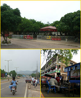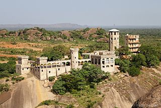
Bolgatanga, colloquially known as Bolga, is a town and the capital of the Bolgatanga Municipal District and Upper East Region of Ghana, adjacent to the border with Burkina Faso. Bolgatanga has over 2012 settlement and a population of about 66,685 people. Bolgatanga is 161 km to the north of Tamale. Bolgatanga lies in the Red Volta River Valley, with the White Volta River and the cliffs of the Gambaga Escarpment to the south of the town forming the southern boundary of the Upper East Region.
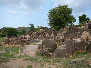
Tongo is a small town near the Upper East region capital of Bolgatanga, and Tongo is the capital of Talensi District, a district in the Upper East Region of Northern part of Ghana. Tongo is known for the, Tengzug shrine, and for its sowing and harvest festivals.

The Upper East Region is located in north Ghana and is the third smallest of the 16 administrative regions in Ghana. It occupies a total land surface of 8,842 square kilometers or 2.7 per cent of the total land area of Ghana. The Upper East regional capital is Bolgatanga, sometimes referred to as Bolga. Other major towns in the region include Navrongo, Paga, Bawku and Zebilla.
The Frafra are a subset of the Gurunsi peoples living in Northern Ghana. The preferred name for the group is Fare-Fare. The adopted name Frafra is a corruption from colonial times of the greeting "Ya fara-fara?" which means "How is your suffering [work]?" It may carry pejorative overtones in local usage. Frafra-language speakers number approximately 300,000. The larger group of Gurunsi people inhabit southern Burkina Faso and Northern Ghana.

Bolgatanga Municipal District is one of the fifteen districts in Upper East Region, Ghana. Originally created as an ordinary district assembly in 1988 when it was known as Bolgatanga District; which was established by Legislative Instrument (L.I.) 1438, until the southeast part of the district was split off by a decree of president John Agyekum Kufuor in August 2004 to create Talensi-Nabdam District; thus the remaining part was elevated to municipal district assembly status on the same year to become Bolgatanga Municipal District, which was established by Legislative Instrument (L.I.) 1797. However, on 15 March 2018, the eastern part of the district was later split off to create Bolgatanga East District, which was established by Legislative Instrument (L.I.) 2321; thus the remaining part has been retained as Bolgatanga Municipal District. The municipality is located in the central part of Upper East Region and has Bolgatanga as its capital town, which also serves as the capital of the Upper East Region.

Kassena-Nankana Municipal is one of the fifteen districts in Upper East Region, Ghana. Originally it was formerly part of the then-larger Kassena-Nankana District in 1988, until the western part of the district was split off to create Kassena-Nankana West District on 29 February 2008; thus the remaining part has been renamed as Kassena-Nankana East District, which it was later elevated to municipal assembly status on 28 June 2012 to become Kassena-Nankana Municipal District. The municipality is located in the western part of Upper East Region and has Navrongo as its capital town.

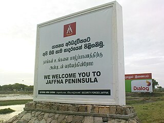
Jaffna Peninsula or is an area in Northern Province, Sri Lanka. It is home to the capital city of the province, Jaffna, and comprises much of the former land mass of the medieval Jaffna kingdom.
Farmer-managed natural regeneration (FMNR) is a low-cost, sustainable land restoration technique used to combat poverty and hunger amongst poor subsistence farmers in developing countries by increasing food and timber production, and resilience to climate extremes. It involves the systematic regeneration and management of trees and shrubs from tree stumps, roots and seeds.

Agriculture in Ghana consists of a variety of agricultural products and is an established economic sector, providing employment on a formal and informal basis. Ghana produces a variety of crops in various climatic zones which range from dry savanna to wet forest which run in east-west bands across Ghana. Agricultural crops, including yams, grains, cocoa, oil palms, kola nuts, and timber, form the base of agriculture in Ghana's economy. In 2013 agriculture employed 53.6% of the total labor force in Ghana.

Agriculture employs the majority of Madagascar's population. Mainly involving smallholders, agriculture has seen different levels of state organisation, shifting from state control to a liberalized sector.

Benin is predominantly a rural society, and agriculture in Benin supports more than 70% of the population. Agriculture contributes around 35% of the country's gross domestic product (GDP) and 80% of export income. While the Government of Benin (GOB) aims to diversify its agricultural production, Benin remains underdeveloped, and its economy is underpinned by subsistence agriculture. Approximately 93% of total agricultural production goes into food production. The proportion of the population living in poverty is about 35.2%, with more rural households in poverty (38.4%) than urban households (29.8%). 36% of households depend solely upon agricultural (crop) production for income, and another 30% depend on crop production, livestock, or fishing for income.

Builsa South is one of the constituencies represented in the Parliament of Ghana. It elects one Member of Parliament (MP) by the first past the post system of election. Builsa South is located in the Builsa district of the Upper East Region of Ghana.

Kajuru is a local government area in southern Kaduna State, Nigeria. Its headquarters is in the town of Kajuru. The local government is located on longitude 9° 59'N and 10° 55'N and latitude 7° 34'E and 8° 13'E, with an area of 2,229 km2.

Agriculture in Sierra Leone is a significant part of the economy of Sierra Leone, with it accounting for 58 percent national Gross Domestic Product (GDP) in 2007. Two-thirds of the population of Sierra Leone are involved in subsistence agriculture.

Kassena-Nankana West District is one of the fifteen districts in Upper East Region, Ghana. Originally, it was formerly part of the then-larger Kassena-Nankana District in 1988, until the western part of the district was split off to create Kassena-Nankana West District on 29 February 2008; thus the remaining part has been renamed as Kassena-Nankana East District. The district assembly is located in the western part of Upper East Region and has Paga as its capital town.
Mozambique has a variety of regional cropping patterns; agro-climatic zones range from arid and semi-arid to the sub-humid zones to the humid highlands. The most fertile areas are in the northern and central provinces, which have high agro-ecological potential and generally produce agricultural surpluses. Southern provinces have poorer soils and scarce rainfall, and are subject to recurrent droughts and floods.
Kumawu is a small town and is the capital of Sekyere Kumawu, a district in the Ashanti Region of Ghana. The town is known for the Tweneboa Kodua Secondary School. The school is a second cycle institution.
The Gologo festival, also known as the Golib festival, is celebrated in the month of March at the end of the dry season before the sewing of the early millet. The Gologo Festival is among the major festivals in Ghana and is celebrated by the chiefs and peoples of Talensi, Tong-Zuf, in the Upper East Region of the country, serving "to reinforce the community belief in the Nnoo shrine or Golib god", which deity regulates Talensi agricultural life. It is a pre-harvest festival celebrated in the months of March and April, with sacrifices offered to seek protection and ensure plentiful rain and a good harvest in the coming season from the earthly gods. The festival has a three-day programme at three different villages. The first part takes place at Gorogo, the second at Yinduri, and the final and biggest at Teng-Zug (Tong-Zuf). Libation is poured at the Teng-Zug shrine to thank the gods for a successful occasion. The one in March is called Gol-diema, which means tutorial. The main Gologo festival is celebrated in the second week in April. Traditional songs are composed by the elders of each community for the occasion and people dance to the composed songs. During this period, noise-making is prohibited and no one mourns their dead. The Gologo festival which is also known as the Golib festival is celebrated in the month of March at the end of the dry season before the sewing of the early millet. Tengzug, Santeng, Wakii, Gbeogo, Yinduri/Zandoya, Shia, Gorogo and Spart are the communities which celebrate the festival. There is a special dress code whereby men wear a short knicker and a towel on the chest. Women are also expected to tie a long towel from their chest down to the feet and cover their heads with a special local-made cloth.

Nabdam District is one of the fifteen districts in Upper East Region, Ghana. Originally it was formerly part of the then-larger Talensi-Nabdam District in August 2004, until the northern part of the district was split off to create Nabdam District on 28 June 2012; thus the remaining part has been renamed as Talensi District. The district assembly is located in the central part of Upper East Region and has Nangodi as its capital town.

Talensi District is one of the fifteen districts in Upper East Region, Ghana. Originally it was formerly part of the then-larger Talensi-Nabdam District in August 2004, until the northern part of the district was split off to create Nabdam District on 28 June 2012; thus the remaining part has been renamed as Talensi District. The district assembly is located in the central part of Upper East Region and has Tongo as its capital town.


