
Bathinda is a city and municipal corporation in Punjab, India. The city is the administrative headquarters of Bathinda District. It is located in northwestern India in the Malwa Region, 227 km (141 mi) west of the capital city of Chandigarh and is the fifth largest city of Punjab. Bathinda is known as the 'City of Lakes' due to the three artificial lakes adjacent to the now-closed Thermal power plant in the northern part of the city.

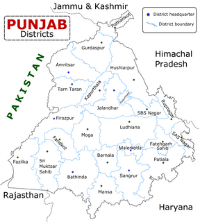
Bathinda district is in Malwa region of Punjab, India. The district encompasses an area of 3,385 square kilometers. By area, Bathinda district is the second-largest in Punjab, after Ludhiana District. It is bounded by Faridkot district and Moga district on the north, Mukatsar district on the west, Barnala and Mansa districts on the east, and the state of Haryana on the south. Bathinda is cotton producing belt of Punjab.
Dhanaula is a city and a municipal council in Barnala district in the state of Punjab, India. Situated 18 km west of Sangrur, Dhanaula lies on the Sangrur-Barnala road. It is about 12 km from Barnala. Dhanaula was founded by Gurditta, eldest son of Taloka, in 1718. It was the capital of the erstwhile Princely State of Nabha until 1755 when Raja Hamir Singh founded Nabha town and made it the capital of the state. He also built a fort which now houses the police station of Dhanaula. A temple of Hanuman exists here. It is said that a man was digging a ditch and found an idol of Hanuman. A temple was constructed at that place, the idol was placed there, and the people began to worship it. Dhanaula is a town of temples.
Moga district is one of the twenty-two districts in the state of Punjab, India. It became the 17th district of Punjab State on 24 November 1995 cut from Faridkot district. Moga District is among the largest producers of wheat and rice in Punjab, India. People from Moga City and Moga District belong to the Malwa culture.
Ahmedgarh is a city and a municipal council in Malerkotla district in the Indian state of Punjab. It is 18 km away from Malerkotla, the district headquarter, 30 km away from Ludhiana city.
Badhni Kalan is a town and a nagar nigham in Moga district in the state of Punjab, India. Kalan is Persian language word which means Big.
Bhucho Mandi is a suburb of Bathinda and a municipal council in Bathinda district in the state of Punjab, India.
Garhdiwala is a town and a municipal council in Hoshiarpur district in the state of Punjab, India.
Mandi Gobindgarh is a town and municipal committee in Fatehgarh Sahib district in the state of Punjab in North India. It is also referred to as Steel City of Punjab or "Loha Mandi" due to its large number of steel factories.
Goniana is a Suburban town in Bathinda District in the Indian state of Punjab. It is located about 12 km from Bathinda City on National Highway 54 It is also known as ‘’’Goniana Mandi’’’.
Jaitu is a historical city. Jaitu is a municipal council in Faridkot district in the Indian state of Punjab. It is subdivision in Ferozepur Division. It is 30 km (19 mi) from Bathinda, 130 km (81 mi) from Ludhiana, 150 km (93 mi)from Amritsar, 180 km (110 mi) from Patiala and 234 km (145 mi) from Chandigarh.
Kalanwali is a city and a municipal committee in Sirsa district in the Indian state of Haryana. Being very near the Punjab border, most of the people in this area have Punjabi as their mother tongue.
Kot Fatta is a city and a municipal council in Bathinda district in the Indian state of Punjab.
The town of Mullanpur Dakha, also known as Mandi Mullanpur, is located in the Ludhiana district in the Indian state of Punjab. It is a nagar panchayat, a settlement in transition from rural to urban. Due to the availability of transport routes to other villages, the town serves as a marketplace of grain and other goods to the surrounding area.
Sangat is a Suburb town of Bathinda City and a municipal council in Bathinda district in the Indian state of Punjab. Sangat Mandi is situated 20 km (12 mi) away from Bathinda District headquarter in south. Sangat is Small commercial hub of area.
Shahkot is a small city and a tehsil among five tehsils of Jalandhar district, Punjab, India. Shahkot is situated on Jalandhar-Moga-Barnala-Sirsa National Highway 703. Shahkot is administered by the Municipal Committee. About 250 villages belong to Shahkot tehsil. Shahkot was famous for its red chili peppers; but now, its main crops are Wheat, Paddy, Maize, potato, etc. Agricultural land is not suitable for paddy. But with the use of pesticides and tubewell water; paddy is grown.
Giddarbaha, is a town and a municipal council in Muktsar district, in the Indian state of Punjab.
Maur is a suburb town of Bathinda City and a municipal council in Bathinda district in the Indian state of Punjab.It has a class II Municipal committee, located on the Bathinda- Delhi railway line, and the Bathinda-Mohali (Ajitgarh) state highway. This State Highway has now been upgraded to National Highway NH 148B. Maur Mandi is about 35 km from Bathinda city.
Barnala is one of the districts of Indian state of Punjab. It was carved out of Sangrur district. It is a centrally located district bordered by Ludhiana district on the north, Moga district on northwest, Bathinda district on west and by Sangrur district on all other sides. As per census 2011, Population of District Barnala is 5,96,294. Barnala has sufficient number of Colleges to provide sufficient education in the field of Engineering, Arts, Medical and Commerce. Also Barnala is well known for its Industries. Two main Industries Trident Group which is mainly known for its world class towels is established in this District. Second a large Industry producing combines, Standard Combines is also established here.
Shian pari is a village in Firozpur district in the Indian state of Punjab. It is situated in between two highways: Amritsar to Bathinda Road and Amristsar to Moga Road. It is situated 1.5 km away from the main Amritsar - Bathinda road, near Makhu and 3 km from the Amritsar-Moga road. It is 12 km away from Tehsil Zira. Two gurdwara are located in the village. One is on the east side of the village and the other one is on the west side. Sardar Piara Singh grandfather of Sardar Lakhwinder Singh, Ravinder Singh, Dilbag Singh came from village Jia Bagga now in Pakistan in 1947.

