Tennessee Ridge, Tennessee | |
---|---|
Coordinates: 36°19′15″N87°45′47″W / 36.32083°N 87.76306°W | |
Country | United States |
State | Tennessee |
Counties | Houston |
Settled | approx. 1780 |
Incorporated (town) | March 5, 1960 |
Government | |
• Mayor | Stony Odom (I) [1] |
Area | |
• Total | 3.76 sq mi (9.73 km2) |
• Land | 3.75 sq mi (9.71 km2) |
• Water | 0.01 sq mi (0.02 km2) |
Elevation | 742 ft (226 m) |
Population | |
• Total | 1,332 |
• Density | 355.20/sq mi (137.15/km2) |
Time zone | UTC-6 (CST) |
• Summer (DST) | UTC-5 (CDT) |
ZIP code | 37178 |
Area code | 931 |
FIPS code | 47-73460 [5] |
GNIS feature ID | 1304045 [3] |
Website | www |
Tennessee Ridge is a town in Houston county in the U.S. state of Tennessee. The population was 1,332 at the 2020 census and 1,368 at the 2010 census.
Tennessee Ridge is located at 36°19′15″N87°45′47″W / 36.32083°N 87.76306°W (36.320797, -87.763012), [6] at an elevation of 742 feet above sea level.
According to the United States Census Bureau, the town has a total area of 3.7 square miles (9.6 km2), of which 3.7 square miles (9.6 km2) is land and 0.27% is water.
The ZIP code used in the Tennessee Ridge area is 37178.
Tennessee Ridge uses the area code 931.
Climate data for Tennessee Ridge, Tennessee (1991–2020 normals, extremes 1999–present) | |||||||||||||
---|---|---|---|---|---|---|---|---|---|---|---|---|---|
Month | Jan | Feb | Mar | Apr | May | Jun | Jul | Aug | Sep | Oct | Nov | Dec | Year |
Record high °F (°C) | 73 (23) | 79 (26) | 87 (31) | 89 (32) | 93 (34) | 108 (42) | 105 (41) | 105 (41) | 102 (39) | 97 (36) | 84 (29) | 75 (24) | 108 (42) |
Mean maximum °F (°C) | 66.0 (18.9) | 70.4 (21.3) | 79.6 (26.4) | 85.5 (29.7) | 88.4 (31.3) | 94.2 (34.6) | 95.5 (35.3) | 97.2 (36.2) | 92.9 (33.8) | 86.8 (30.4) | 75.9 (24.4) | 70.4 (21.3) | 98.5 (36.9) |
Mean daily maximum °F (°C) | 46.6 (8.1) | 51.2 (10.7) | 60.8 (16.0) | 70.9 (21.6) | 78.3 (25.7) | 85.6 (29.8) | 88.9 (31.6) | 88.8 (31.6) | 82.5 (28.1) | 72.1 (22.3) | 59.3 (15.2) | 49.9 (9.9) | 69.6 (20.9) |
Daily mean °F (°C) | 36.4 (2.4) | 39.9 (4.4) | 48.6 (9.2) | 58.3 (14.6) | 67.1 (19.5) | 74.7 (23.7) | 78.4 (25.8) | 77.7 (25.4) | 71.0 (21.7) | 60.2 (15.7) | 48.5 (9.2) | 39.9 (4.4) | 58.4 (14.7) |
Mean daily minimum °F (°C) | 26.2 (−3.2) | 28.7 (−1.8) | 36.4 (2.4) | 45.7 (7.6) | 55.9 (13.3) | 63.9 (17.7) | 67.9 (19.9) | 66.5 (19.2) | 59.5 (15.3) | 48.3 (9.1) | 37.6 (3.1) | 29.8 (−1.2) | 47.2 (8.4) |
Mean minimum °F (°C) | 9.7 (−12.4) | 11.9 (−11.2) | 22.0 (−5.6) | 30.5 (−0.8) | 41.1 (5.1) | 55.6 (13.1) | 60.1 (15.6) | 59.0 (15.0) | 49.4 (9.7) | 33.6 (0.9) | 22.5 (−5.3) | 15.5 (−9.2) | 7.2 (−13.8) |
Record low °F (°C) | 0 (−18) | 4 (−16) | 9 (−13) | 16 (−9) | 28 (−2) | 42 (6) | 51 (11) | 48 (9) | 42 (6) | 29 (−2) | 11 (−12) | −9 (−23) | −9 (−23) |
Average precipitation inches (mm) | 4.00 (102) | 4.64 (118) | 6.00 (152) | 5.95 (151) | 5.17 (131) | 4.00 (102) | 4.04 (103) | 3.58 (91) | 3.02 (77) | 4.73 (120) | 4.71 (120) | 4.91 (125) | 54.75 (1,392) |
Average precipitation days (≥ 0.01 in) | 8.6 | 9.1 | 9.4 | 10.0 | 10.4 | 9.2 | 7.9 | 7.8 | 6.9 | 7.8 | 8.4 | 9.5 | 105.0 |
Source 1: NOAA [7] | |||||||||||||
Source 2: National Weather Service (mean maxima/minima 2006–2020) [8] |
Census | Pop. | Note | %± |
---|---|---|---|
1960 | 324 | — | |
1970 | 664 | 104.9% | |
1980 | 1,325 | 99.5% | |
1990 | 1,271 | −4.1% | |
2000 | 1,334 | 5.0% | |
2010 | 1,368 | 2.5% | |
2020 | 1,332 | −2.6% | |
Sources: [9] [10] [4] |
Race | Number | Percentage |
---|---|---|
White (non-Hispanic) | 1,218 | 91.44% |
Black or African American (non-Hispanic) | 18 | 1.35% |
Native American | 5 | 0.38% |
Asian | 1 | 0.08% |
Pacific Islander | 1 | 0.08% |
Other/Mixed | 52 | 3.9% |
Hispanic or Latino | 37 | 2.78% |
As of the 2020 United States census, there were 1,332 people, 501 households, and 306 families residing in the town.
As of the census [5] of 2000, there were 1,334 people, 533 households, and 412 families residing in the town. The population density was 360.3 inhabitants per square mile (139.1/km2). There were 573 housing units at an average density of 154.7 per square mile (59.7/km2). The racial makeup of the town was 98.80% White, 0.22% African American, 0.15% Asian, 0.30% Pacific Islander, 0.37% from other races, and 0.15% from two or more races. Hispanic or Latino of any race were 1.05% of the population.
There were 533 households, out of which 29.1% had children under the age of 18 living with them, 62.5% were married couples living together, 10.3% had a female householder with no husband present, and 22.7% were non-families. 20.1% of all households were made up of individuals, and 9.6% had someone living alone who was 65 years of age or older. The average household size was 2.48 and the average family size was 2.82.
In the town, the population was spread out, with 23.1% under the age of 18, 6.3% from 18 to 24, 25.9% from 25 to 44, 26.0% from 45 to 64, and 18.7% who were 65 years of age or older. The median age was 41 years. For every 100 females, there were 95.3 males. For every 100 females age 18 and over, there were 92.1 males.
The median income for a household in the town was $33,029, and the median income for a family was $35,880. Males had a median income of $28,833 versus $24,659 for females. The per capita income for the town was $14,460. About 8.2% of families and 11.7% of the population were below the poverty line, including 13.5% of those under age 18 and 7.7% of those age 65 or over.
Raymond is a village in Montgomery County, Illinois, United States. The population was 949 at the 2020 census.
Center Point is a town in Sugar Ridge Township, Clay County, Indiana, United States. The population was 242 at the 2010 census. It is part of the Terre Haute Metropolitan Statistical Area.
Hardin is a home rule-class city in Marshall County, Kentucky, United States. The population was 580 at the 2020 census.
Turtle River is a town in Beltrami County, Minnesota, United States. The population was 77 at the 2010 census. The elevation is 1,332 ft (406m). It is approximately 17 miles northeast of Bemidji, where most community services are available. Turtle River consists of two stores, a restaurant, a gas station, and a church.
Kingston Springs is a town in Cheatham County, Tennessee, United States. As of the 2020 census, the population was 2,824.
Burns is a town in Dickson County, Tennessee, in the United States. It is part of the Nashville-Davidson–Murfreesboro–Franklin, TN Metropolitan Statistical Area. The population was 1,468 at the 2010 census.
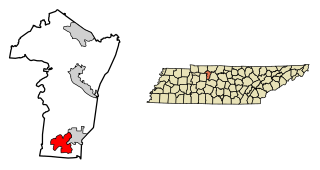
Charlotte is a town in Dickson County, Tennessee, United States. The population was 1,656 at the 2020 census. It is the county seat of Dickson County. This town is part of the Nashville metropolitan area.
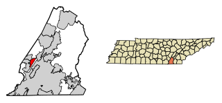
Dickson is a city in the U.S. state of Tennessee. Located in Dickson County. It is part of the Nashville metropolitan area. As of the 2020 census, Dickson's population was 16,058.
Vanleer is a town in Dickson County, Tennessee, United States. The population was estimated to be 422 in 2019, up from 395 at the 2010 census. The town is approximately 49 miles northwest of Nashville and is located within the city's greater metropolitan area.
Walden is a town located in Hamilton County, Tennessee, United States. The population was 1,981 at the 2020 census and up from 1,898 at the 2010 census. It is part of the Chattanooga, Tennessee–Georgia Metropolitan Statistical Area.
Erin is a city in and the county seat of Houston County, Tennessee. The population was 1,224 at the time of the 2020 census and 1,324 at the time of the 2010 census.
New Johnsonville is a city in Humphreys County, Tennessee, United States. The population was 1,951 at the 2010 census.
Ridgely is a town in Lake County, Tennessee, United States. The population was 1,667 at the 2000 census and 1,795 at the 2010 census.
Livingston is a town in Overton County, Tennessee, United States, and serves as the county seat. The population was 3,905 at the 2020 census and 4,058 at the 2010 census. The current mayor, Curtis Hayes, began serving his mayoral position in September 2006.
Helenwood is an unincorporated community in Scott County, Tennessee, United States. The population was 846 at the 2000 census, when Helenwood was treated as an incorporated municipality. For the 2010 census, it was a census-designated place (CDP) with a population of 865.
Gordonsville is a town in Smith County, Tennessee, United States. The population was 1,213 at the 2010 census.
Dover is a city in and the county seat of Stewart County, Tennessee, 67 miles (108 km) west-northwest of Nashville on the Cumberland River. Fort Donelson National Cemetery is in Dover. The population was 1,442 at the 2000 census and the 2010 census showed a population of 1,417.
Sharon is a town in Weakley County, Tennessee, United States. The population was 988 at the 2000 census and 944 at the 2010 census.
Kenton is a town in Gibson and Obion counties, Tennessee. The population was 1,281 at the 2010 census, a decline of 25 from 2000. The Gibson County portion of Kenton is part of the Humboldt, TN Micropolitan Statistical Area, while the Obion County portion is part of the Union City, TN–KY Micropolitan Statistical Area.
Holland is a town in Erie County, New York, United States. The population was 3,401 at the 2010 census. The name is derived from the Holland Land Company, the original title-holder to most of the land of Western New York.