Terra Tower

Last updated
Terra Tower
Terra Tower.jpg
Northeast aspect
Highest point
Elevation 5,790 ft (1,760 m) [1]
Prominence 60 ft (18 m) [1]
Parent peak Black Ridge [1]
Isolation 3.76 mi (6.05 km) [1]
Coordinates 39°04′12″N108°40′40″W / 39.0699°N 108.6777°W / 39.0699; -108.6777
Geography
USA Colorado relief location map.svg
Red triangle with thick white border.svg
Terra Tower
Location in Colorado
Usa edcp relief location map.png
Red triangle with thick white border.svg
Terra Tower
Terra Tower (the United States)
Location Colorado National Monument
Mesa County, Colorado, U.S.
Parent range Colorado Plateau
Uncompahgre Plateau
Topo map USGS Colorado National Monument
Geology
Age of rock Late Triassic to Early Jurassic [2]
Type of rock Wingate Sandstone
Climbing
First ascent 1979
Easiest route class 5.11 climbing

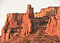
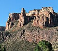
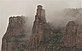
Terra Tower is a 5,790-foot-elevation (1,760-meter) sandstone pillar located in Colorado National Monument, in Mesa County of western Colorado, United States. [3] This 350-foot-high tower is situated on the Redlands escarpment, approximately seven miles west of the community of Grand Junction. Topographic relief is significant as it rises 1,000 feet (300 meters) above the Tiara Rado Golf Course in approximately one-half mile. The first ascent of the summit was made in 1979 by Harvey Carter and Tom Merrill via the class 5.11 route, Way Bazaar.

Contents

Geology

This tower is the remnant of a differentially eroded fin composed primarily of cliff-forming Wingate Sandstone, which consists of wind-borne, cross-bedded quartzose sandstones deposited as ancient sand dunes approximately 200 million years ago in the Late Triassic. The caprock at the summit consists of fluvial sandstones of the resistant Kayenta Formation. The slope around the base of Terra Tower is Chinle Formation. [4] Precipitation runoff from this geographical feature drains to the Colorado River, approximately two miles to the northeast.

Climate

According to the Köppen climate classification system, Terra Tower is located in a semi-arid climate zone. [5] Summers are hot and dry, while winters are cold with some snow. Temperatures reach 100 °F (38 °C) on 5.3 days, 90 °F (32 °C) on 57 days, and remain at or below freezing on 13 days annually. The months April through October offer the most favorable weather to visit.

Climbing

Established rock climbing routes on Terra Tower: [6]

See also

Related Research Articles

<span class="mw-page-title-main">Monster Tower</span>

Monster Tower is a 600-foot (180-meter) tall sandstone tower located in the Island in the Sky District of Canyonlands National Park, in San Juan County, Utah, United States.

<span class="mw-page-title-main">Washer Woman</span> Sandstone arch and tower in Utah, US

Washer Woman is a 500-foot (150-meter) tall sandstone arch and tower located in the Island in the Sky District of Canyonlands National Park, in San Juan County, Utah. It is situated 300 feet northwest of the slightly higher Monster Tower. Washer Woman is so named because the feature gives the appearance of a washerwoman bent over a washtub. This geographical feature's name was officially adopted in 1986 by the U.S. Board on Geographic Names after previously having similar names such as Washer-Woman Arch and The Washer Woman. Washer Woman and Monster Tower are an eroded fin composed of Wingate Sandstone, which is the remains of wind-borne sand dunes deposited approximately 200 million years ago in the Late Triassic. Airport Tower is set 1.6 mi (2.6 km) to the east, and Mesa Arch is situated 1.5 mi (2.4 km) to the west. A short hike to Mesa Arch provides the easiest view of Washer Woman. Access to this formation is via the four-wheel drive White Rim Road, which is the other option to see it. The top of this geological formation rises 1,300 feet above the road in approximately one mile. Precipitation runoff from Washer Woman drains southeast into the nearby Colorado River via Buck Canyon.

<span class="mw-page-title-main">Owl Rock</span> Landform in Navajo County, Arizona

Owl Rock is a 6,547-foot elevation sandstone summit located south of Monument Valley, in northeast Arizona. It is situated 7 miles (11 km) north of Kayenta on Navajo Nation land, and can be seen from Highway 163 perched on the east edge of Tyende Mesa, where it towers 1,000 feet above the surrounding terrain. Its nearest higher neighbor is Agathla Peak, 1.4 miles (2.3 km) to the east-northeast, on the opposite side of this highway. Precipitation runoff from this feature drains into El Capitan Wash, which is part of the San Juan River drainage basin. The first ascent of Owl Rock was made in April 1966 by Fred Beckey and Harvey Carter by climbing cracks on the west face, and then bolting up a smooth south nose to the summit. They employed 20 pitons and 14 bolts on this route called Warpath. The descriptive name stems from its uncanny resemblance to an owl when viewed from the east. This feature is known as Bee 'Adizí in Navajo language meaning "spindle", and this sacred place is considered to be a spindle left behind by the Holy People. A newer name for it is Tsé Ts'óózí, meaning "Slim Rock".

<span class="mw-page-title-main">Airport Tower (Canyonlands)</span>

Airport Tower is a 700-foot (210-meter) tall sandstone butte located in the Island in the Sky District of Canyonlands National Park, in San Juan County, Utah. It is situated 1.64 mile east of Washer Woman, which is a towering arch similar in height. Each are composed of Wingate Sandstone, which is the remains of wind-borne sand dunes deposited approximately 200 million years ago in the Late Triassic. The nearest higher neighbor is Monster Tower, 1.6 mi (2.6 km) to the west, Tiki Tower is one-half mile northwest, and Mesa Arch is situated 3.2 mi (5.1 km) to the west. A short hike to Mesa Arch provides the easiest view of Airport Tower. Access to this tower is via the four-wheel drive White Rim Road, which is another option to see Airport Tower. The top of this geological formation rises 1,400 feet above the road in less than one mile. Precipitation runoff from Airport Tower drains southeast into the nearby Colorado River via Buck and Lathrop Canyons. This geographical feature's name was officially adopted in 1986 by the U.S. Board on Geographic Names. It was so named because the rock formation resembles the appearance of an airport control tower.

<span class="mw-page-title-main">Zeus and Moses</span> Rock formations in Utah, United States

Zeus and Moses are a pair of 500-foot-tall (150 m) sandstone formations located in the Island in the Sky District of Canyonlands National Park, in San Juan County, Utah, United States. These rock towers' names refer to Zeus, a god in Greek mythology, and Moses, an important prophet in several religious traditions. Zeus and Moses are composed of Wingate Sandstone, which is the remains of wind-borne sand dunes deposited approximately 200 million years ago in the Late Triassic. This formation is situated in Taylor Canyon, 3 mi (4.8 km) north-northeast of Upheaval Dome. Access to the towers is via the four-wheel-drive White Rim Road, and a spur road into Taylor Canyon. The top of this geological formation rises 900 feet above the canyon floor at road's end, approximately one-half mile away. Precipitation runoff from Zeus and Moses drains into the nearby Green River via Taylor Canyon.

<span class="mw-page-title-main">Tower Butte</span>

Tower Butte is a 5,287-foot elevation sandstone summit located south of Lake Powell, in northern Arizona. Tower Butte is a butte composed of Romana and Entrada Sandstones with a Morrison Formation caprock. It is situated 9 miles (14 km) northeast of the town of Page, and 7.5 miles north of LeChee Rock, on Navajo Nation land, towering over 1,000 feet above the surrounding terrain as an iconic landmark of the area. Precipitation runoff from this feature drains into Lake Powell, which is part of the Colorado River drainage basin. The first ascent of Tower Butte was made October 23, 1994, by Jason Keith and David Insley. However, they were not the first to visit the summit as they reported finding litter from prior helicopter landings. An outfit operating out of Page flies helicopter sightseeing flights which land on the flat top of the butte where tourists have panoramic views of the Glen Canyon National Recreation Area, Lake Powell, and Navajo Mountain.

<span class="mw-page-title-main">Buttes of the Cross</span>

Buttes of the Cross is two sandstone summits located in the northern reach of Glen Canyon National Recreation Area, in Wayne County of Utah, United States. The larger and higher south butte reaches an elevation of 5,642 feet, whereas the north butte rises to 5,569 feet, with approximately 0.6 miles (0.97 km) separation between them. When viewed from the north-northeast near Labyrinth Canyon, they align to form the shape of a cross, creating the appearance of a single butte. The name "Butte of the Cross" was first applied by John Wesley Powell during the Powell Geographic Expedition of 1869. A few miles further down the Green River, Powell finds that this geographical feature is two buttes when viewed from the east, so it was renamed Buttes of the Cross. Buttes of the Cross towers over 1,400 feet above its surrounding terrain. It is situated 6.8 miles west of Candlestick Tower, and one-half mile outside the boundary of Canyonlands National Park.

<span class="mw-page-title-main">Chip and Dale Towers</span>

Chip and Dale Towers are two 300-foot (91-meter) tall sandstone towers located in the Island in the Sky District of Canyonlands National Park, in San Juan County, Utah. Dale Tower rises to an elevation of 5,620 feet, whereas the lower Chip Tower is 5,420-feet. Airport Tower is set 2.5 mi (4.0 km) to the southwest, and Dead Horse Point State Park overlook is situated 4.5 mi (7.2 km) to the north-northeast. Chip and Dale Towers are an eroded fin composed of hard, fine-grained Wingate Sandstone, which is the remains of wind-borne sand dunes deposited approximately 200 million years ago in the Late Triassic. This Wingate Sandstone overlays a softer layer of the Chinle Formation. Access to the towers is via the four-wheel drive White Rim Road, and a scramble to reach the base. The top of the towers rise over 1,000 feet above the road in approximately one-half mile. Precipitation runoff from Chip and Dale Towers drains east to the nearby Colorado River.

<span class="mw-page-title-main">Sixshooter Peaks</span>

The Sixshooter Peaks are two iconic sandstone summits located in Bears Ears National Monument in San Juan County, Utah, United States. The larger and higher North Sixshooter Peak rises to an elevation of 6,379 feet, whereas South Sixshooter Peak rises to 6,154 feet, with approximately 1.5 miles (2.4 km) separation between the two. These buttes tower nearly 1,400 feet above the surrounding terrain, and are historic landmarks visible from State Route 211 between Newspaper Rock and the Needles District of Canyonlands National Park. They are situated 1.5 mile outside the boundary of the park, and four miles northwest of Bridger Jack Butte. Variant names for the peaks include "North Six-Shooter Peak", "South Six-shooter Peak", "Six Shooter Peaks", and "Six-shooter Peak". They are so named because of their resemblance to a pair of revolvers pointing skyward.

<span class="mw-page-title-main">Bridger Jack Butte</span> Rock formation in Utah, United States

Bridger Jack Butte is a sandstone butte located in Bears Ears National Monument, in San Juan County, Utah, United States. Set at the northern tip of Bridger Jack Mesa and above the confluence of Indian and Lavender Creeks, the summit rises to an elevation of 5,890 feet, and towers over 700 feet above the surrounding terrain and floor of Lavender Canyon to its west. This landmark is situated four miles southeast of the Sixshooter Peaks, and is visible from State Route 211 between Newspaper Rock and the Needles District of Canyonlands National Park. "Bridger Jack" was a Paiute medicine man.

<span class="mw-page-title-main">Window Blind Peak</span>

Window Blind Peak is a 7,030-foot-elevation (2,143-meter) summit located in the San Rafael Swell of Emery County, Utah, U.S. Towering 1,800 feet above its surrounding terrain, it is the highest point of the Mexican Mountain Wilderness Study Area. Ownership is administered by the Bureau of Land Management. It is situated 2.1 miles (3.4 km) southeast of Bottleneck Peak, 1.52 miles (2.45 km) south of Assembly Hall Peak, and the nearest higher neighbor is Cedar Mountain, 8.95 miles (14.40 km) to the north-northeast. Precipitation runoff from this feature drains north into the nearby San Rafael River. The first ascent of this peak was made September 23, 1973, by Jim Langdon, Dale Black, and Dave Palmer via the West Face.

<span class="mw-page-title-main">LeChee Rock</span> Landform in Coconino County, Arizona

LeChee Rock is a 5,900-foot-elevation (1,800 m) sandstone feature located south of Lake Powell, in Coconino County of northern Arizona. It is situated nine miles (14 km) east-southeast of the town of Page, eight miles (13 km) east of the community of LeChee, and 7.5 miles (12.1 km) south of Tower Butte, on Navajo Nation land, where it towers over 900 feet (270 m) above the surrounding terrain as a landmark of the area. It can be seen from nearby Arizona State Route 98, or from as far away as Alstrom Point. LeChee (Łichíí) in Navajo language means red, referring to burgundy-colored leaves of a medicinal plant. The spelling for this geographical feature's name was officially adopted in 2004 by the U.S. Board on Geographic Names, prior to that it was officially Leche-e Rock.

<span class="mw-page-title-main">Mount Hayden (Arizona)</span> Landform in the Grand Canyon, Arizona

Mount Hayden is an 8,362-foot (2,549 m)-elevation summit located in the Grand Canyon, in Coconino County of Arizona, United States. It is situated one-half mile (0.80 km) southeast of the Point Imperial viewpoint, on the canyon's North Rim, where it towers 5,000 feet (1,500 m) above the bottom of Nankoweap Canyon. Mount Hayden, also known as Hayden Peak, is named for Charles T. Hayden (1825–1900), an Arizona pioneer influential in the development of the Arizona Territory where he was known as the "Father of Tempe", and he established Arizona State University. He was also the father of US Senator Carl Hayden, as well as a probate judge. This geographical feature's name was officially adopted in 1932 by the U.S. Board on Geographic Names.

The first ascent of the summit was made in May 1978 by Joe Sharber, George Bain, and Abra Watkins via the north side. Pegasus, a challenging class 5.10+ route on the East Face, was first climbed by Paul Davidson and Jim Haisley in 1982. The most popular climbing route is the class 5.8 South Face. According to the Köppen climate classification system, Mount Hayden is located in a Cold semi-arid climate zone.

<span class="mw-page-title-main">Zoroaster Temple</span> Landform in Coconino County, Arizona

Zoroaster Temple is a 7,123-foot-elevation (2,171-meter) summit located in the Grand Canyon, in Coconino County of Arizona, USA. It is situated 5.5 miles (8.9 km) northeast of the Yavapai Point overlook on the canyon's South Rim, from which it can be seen towering over 4,600 feet above the Colorado River and Granite Gorge. Its nearest higher neighbor is Brahma Temple, less than one mile to the north-northeast. Zoroaster Temple is named for Zoroaster, an ancient Iranian prophet. This name was used by George Wharton James and Clarence Dutton. Dutton began the tradition of naming geographical features in the Grand Canyon after mythological deities. This geographical feature's name was officially adopted in 1906 by the U.S. Board on Geographic Names.

<span class="mw-page-title-main">Independence Monument (Colorado)</span>

Independence Monument is a 5,739-foot-elevation sandstone pillar located in Colorado National Monument, in Mesa County of western Colorado, United States. This iconic 450-foot-high landmark is situated one mile southeast of the monument's visitor center, and 9 miles (14 km) west of the community of Grand Junction, where it towers above the floor of Monument Canyon and Wedding Canyon. It is a popular climbing destination, and can be seen from Rim Rock Drive.

<span class="mw-page-title-main">Kissing Couple</span>

Kissing Couple is a 5,815-foot-elevation (1,772-meter) sandstone pillar located in Colorado National Monument, in Mesa County of western Colorado, United States. This iconic 400-foot-high tower is situated on the west side of Monument Canyon, 1.5 mile southeast of the monument's visitor center, and 9 miles (14 km) west of the community of Grand Junction. It is also a half-mile south-southeast of another popular climbing destination, Independence Monument, and both can be seen from viewpoints along Rim Rock Drive. It is so named because it resembles an embracing couple. This geographical feature's name was officially adopted in 1982 by the United States Board on Geographic Names. Older USGS maps have the feature's name misplaced by about one-half mile to the southeast. The first ascent of the summit was made May 4, 1960, by Layton Kor, Harvey Carter, and John Auld via the five pitch, class 5.11a route named Long Dong Wall. The first free ascent was made in 1977 by Andy Petefish, Tom Stubbs, and Jim Pearson. Some climbers alternatively refer to Kissing Couple as "Bell Tower."

<span class="mw-page-title-main">Pipe Organ (Colorado National Monument)</span>

Pipe Organ is a 5,731-foot-elevation (1,747-meter) sandstone pillar located in Colorado National Monument, in Mesa County of western Colorado, United States. This 400+ foot tower is situated in Wedding Canyon, less than one-half mile east of the monument's visitor center, and 9 miles (14 km) west of the community of Grand Junction. It is also immediately northwest of another popular climbing destination, Independence Monument, and both can be seen from viewpoints along Rim Rock Drive. The first ascent of the summit was made January 31, 1961, by John Auld, Gary Ziegler, Jim Dyson, and John Kuglin. Pipe Organ has a subsidiary summit unofficially named Organ Pipe Spire on the east aspect, which the National Park Service refers to as Praying Hands. This 325-foot-high subsidiary peak was originally named Squall Spire in 1976 by Harvey T. Carter of the first ascent party.

<span class="mw-page-title-main">Sentinel Spire</span>

Sentinel Spire is a 5,500-foot-elevation (1,700-meter) sandstone pillar located in Colorado National Monument, in Mesa County of western Colorado, United States. This 200-foot freestanding tower is situated in Wedding Canyon, one-half mile east of the monument's visitor center, and 9 miles (14 km) west of the community of Grand Junction. It is also immediately south of Window Rock, and north of another climbing destination, Pipe Organ, both of which can be seen from viewpoints along Rim Rock Drive. The first ascent of the summit was made May 3, 1960, by Layton Kor, Harvey Carter, and John Auld via the class 5.10 route, Fast Draw. This was the day before the climbers also made the first ascent of nearby Kissing Couple. The first solo ascent was made by Ron Olevsky in March 1976, and the first free ascent was made by Andy Petefish and John Christenson in 1978. Some climbers refer to Sentinel Spire as Watusi Spear.

<span class="mw-page-title-main">Grand View Spire</span> Sandstone formation in Colorado

Grand View Spire is a 5,821-foot-elevation (1,774-meter) sandstone pillar located in Colorado National Monument, in Mesa County of western Colorado, United States. This 400-foot tower is situated on the west side of Monument Canyon, one mile southeast of the monument's visitor center, and 9 miles (14 km) west of the community of Grand Junction. It is also 0.32 mile immediately south of Independence Monument, and 0.27 mile northwest of another climbing destination, Kissing Couple. Its unofficial name relates to its position at the tip of Grand View Overlook, one of several scenic viewpoints along Rim Rock Drive.

<span class="mw-page-title-main">Coxcomb Peak (Colorado)</span> Mountain in the state of Colorado

Coxcomb Peak is a 13,656-foot-elevation (4,162-meter) mountain summit located on the common boundary of Hinsdale County and Ouray County, in Colorado, United States. It is situated nine miles northeast of the community of Ouray, in the Uncompahgre Wilderness, on land managed by Uncompahgre National Forest. It is part of the San Juan Mountains which are a subset of the Rocky Mountains, and is situated west of the Continental Divide. Coxcomb ranks as the 171st-highest peak in Colorado, and topographic relief is significant as the south aspect rises 2,000 feet above Wetterhorn Basin in approximately one mile, and 4,400 feet above Cow Creek in three miles. Neighbors include Precipice Peak 2.7 miles to the north, Redcliff one-half mile north, Matterhorn Peak 2.3 miles to the east-southeast, and nearest higher neighbor Wetterhorn Peak 1.8 mile to the southeast. The mountain's descriptive name, which has been officially adopted by the United States Board on Geographic Names, was in use since at least 1906 when Henry Gannett published it in the Gazetteer of Colorado.

References

  1. 1 2 3 4 "Terra Tower - 5,790' CO". listsofjohn.com. Retrieved 2021-07-15.
  2. Geologic Formations, National Park Service
  3. Stewart M. Green, 2019, Rock Climbing Colorado A Guide to More Than 1,800 Routes, Falcon Guides, ISBN   9781493037353, page 463.
  4. Stanley William Lohman, The Geologic Story of Colorado National Monument, Geological Survey Bulletin 1508, pages 28-30.
  5. Peel, M. C.; Finlayson, B. L.; McMahon, T. A. (2007). "Updated world map of the Köppen−Geiger climate classification". Hydrol. Earth Syst. Sci. 11. ISSN   1027-5606.
  6. Stewart M. Green, 2019, Rock Climbing Colorado A Guide to More Than 1,800 Routes, Falcon Guides, ISBN   9781493037353, page 465.