
Perth is the capital city of Western Australia. It is the fourth most populous city in Australia, with a population of over 2.3 million within Greater Perth as of 2023. It is part of the South West Land Division of Western Australia, with most of Perth's metropolitan area on the Swan Coastal Plain between the Indian Ocean and the Darling Scarp. The city has expanded outward from the original British settlements on the Swan River, upon which its central business district and port of Fremantle are situated.

Yagan was an Aboriginal Australian warrior from the Noongar people. Yagan was pursued by the local authorities after he killed Erin Entwhistle, a servant of farmer Archibald Butler. It was an act of retaliation after Thomas Smedley, another of Butler's servants, shot at a group of Noongar people stealing potatoes and fowls, killing one of them. The government offered a bounty for Yagan's capture, dead or alive, and a young settler, William Keats, shot and killed him. He is considered a legendary figure by the Noongar.

Heirisson Island is an island in the Swan River in Western Australia at the eastern end of Perth Water, between the suburbs of East Perth and Victoria Park. It occupies an area of 285,600 square metres, and is connected to the two foreshores by The Causeway and the under-construction Causeway Pedestrian and Cyclist Bridges. The next upstream island is Kuljak Island, then Ron Courtney Island, with no islands in the Swan River downstream between Heirisson Island and the Indian Ocean other than the artificial islet in Elizabeth Quay.

Beeliar is a suburb of Perth, Western Australia, located within the City of Cockburn. The name refers to the Beeliar people, a group of Aboriginal Australians who had land rights over the southern half of Perth's metropolitan area. The suburb contains the Thomsons Lake Nature Reserve.

Mount Eliza is a hill that overlooks the city of Perth, Western Australia and forms part of Kings Park. It is known as Kaarta Gar-up and Mooro Katta in the local Noongar dialect.
Noongar is an Australian Aboriginal language or dialect continuum, spoken by some members of the Noongar community and others. It is taught actively in Australia, including at schools, universities and through public broadcasting. The country of the Noongar people is the southwest corner of Western Australia. Within that region, many Noongar words have been adopted into English, particularly names of plants and animals.
Rita Saffioti is an Australian politician. Representing the Australian Labor Party, she has been the member for the electoral district of West Swan in the Western Australian Legislative Assembly, the lower house of the Parliament of Western Australia, since 6 September 2008. Since June 2023, she has been the deputy premier of Western Australia, the treasurer of Western Australia, the minister for transport, and the minister for tourism. From March 2017 to June 2023, she was the minister for transport and minister for planning. From March 2021 to June 2023, she was also the minister for ports. From March 2017 to December 2018, she was also the minister for lands.
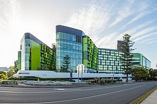
Perth Children's Hospital (PCH) is a specialist children's hospital in Nedlands, Western Australia, located at the corner of Winthrop Avenue and Monash Avenue on the Queen Elizabeth II Medical Centre (QEII) site. It is Western Australia's specialist paediatric hospital and trauma centre, providing medical care to children and adolescents up to 16 years of age.

Yagan Square is a public space and a component of the Perth City Link in Perth, Western Australia. It is situated between the Horseshoe Bridge and the Perth Busport in the eastern part of the Perth City Link precinct, occupying 1.1 hectares. Construction of the square began in February 2016, and it was opened on 3 March 2018. It is named after the Aboriginal warrior Yagan.

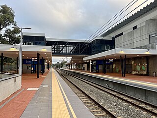
Aubin Grove railway station is a suburban railway station serving Atwell, Aubin Grove, Hammond Park and Success, which are suburbs of Perth, Western Australia. It is on the Mandurah line, which is part of the Transperth network, and is located immediately north of Russell Road in the median of the Kwinana Freeway. It has two platform faces on a singular island platform, which is linked to either side of the freeway by a pedestrian overpass. Services run every 10 minutes during peak and every 15 minutes between peak. The journey to Perth station is 23.8 kilometres (14.8 mi) and takes 21 minutes. The station has a bus interchange with four bus stands and seven regular bus routes.

Airport Central railway station is an underground Transperth commuter rail station at terminals one and two of Perth Airport in Western Australia. The station is located on the Airport line and is one of three stations that were built as part of the Forrestfield–Airport Link project.

High Wycombe railway station is a Transperth commuter rail station in Perth, Western Australia. The station is the eastern terminus of the Airport line and was one of three stations built as part of the Forrestfield–Airport Link project.
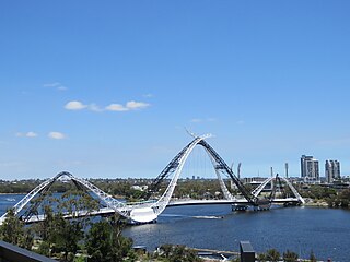
Matagarup Bridge is a suspension pedestrian bridge crossing over the Swan River in Perth, Western Australia. Situated approximately half-way between Heirisson Island and the Goongoongup Bridge, it provides pedestrian access between Burswood and East Perth. The bridge connects visitors to the Burswood Peninsula, including the Perth Stadium, with public transport and car parks in East Perth and the Perth central business district.
David Robert Michael is an Australian politician. He has been a Labor member of the Western Australian Legislative Assembly since the 2017 state election, representing Balcatta. Michael is the WA Parliament's first MP of Finnish descent.

The Morley–Ellenbrook line is an under construction suburban railway line and service in Perth, Western Australia, which will be operated by the Public Transport Authority as part of the Transperth system. The line branches from the Midland line at Bayswater station and heads north-north-west to serve five new stations along a 21.3-kilometre (13.2 mi) route to Ellenbrook. Morley–Ellenbrook line services will continue west of Bayswater station alongside Midland and Airport line services to terminate at Perth station in the central business district.

Ellenbrook railway station is an unopened suburban railway station in Ellenbrook, a suburb of Perth, Western Australia. The station is the north-eastern terminus of the under-construction Morley–Ellenbrook line.

Henley Brook bus station is a Transperth bus station located on the corner of Henley Street and Starflower Road, in Henley Brook, Perth, Western Australia. It has six stands served by six regular Transperth routes operated by Swan Transit.
Civmec Limited is a dual-listed Australian-Singaporean public company involved in the construction, engineering and shipbuilding industries. Headquartered in Perth, Western Australia, it specialises in fabrication and construction for the oil and gas and mining industries and has been involved in a number of significant Australian mining and civil engineering projects and has been selected to build a number of vessels and facilities for the Royal Australian Navy.
Lakelands railway station is a railway station along the Mandurah line on the Transperth network in Western Australia. The station is in the Mandurah suburb of Lakelands, 6.5 kilometres (4.0 mi) north of Mandurah station and 64.5 kilometres (40.1 mi) south of Perth Underground station. Construction started in 2021 and it opened on 11 June 2023.
The Causeway Pedestrian and Cyclist Bridges are a pair of cable-stayed bridges under construction in Perth, Western Australia, linking East Perth with Victoria Park across the Swan River via Heirisson Island. The two bridges are slightly downstream of The Causeway, which is the road linking East Perth with Victoria Park. Construction began in March 2023 and is expected to be complete by the end of 2024.

