
Peace River, originally named Peace River Crossing, and known as Rivière-la-Paix in French, is a town in northwestern Alberta, Canada, situated along the banks of the Peace River, at its confluence with the Smoky River, the Heart River and Pat's Creek. It is located 486 kilometres (302 mi) northwest of Edmonton, and 198 kilometres (123 mi) northeast of Grande Prairie, along Highway 2. It was known as the Village of Peace River Crossing between 1914 and 1916.
Deadwood is a hamlet in Alberta, Canada within the County of Northern Lights. It is located on Highway 690, approximately 10 kilometres (6.2 mi) east of the Mackenzie Highway, 80 kilometres (50 mi) north of Peace River and 34 kilometres (21 mi) southeast of Manning.

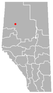
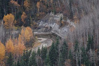
St. Isidore is a hamlet in northwest Alberta, Canada, within Northern Sunrise County. It is located approximately 16 kilometres (9.9 mi) east of the Town of Peace River on Range Road 204 off Highway 688. St. Isidore is flanked by deep ravines cut by Pat's Creek to the north and Pat's Creek tributary to the south. The ravines are surrounded by pine forests.

Division No. 17 is a census division in Alberta, Canada. It spans the central and northwest portions of northern Alberta and its largest urban community is the Town of Slave Lake. Division No. 17 is the largest census division in Alberta according to area and also has the lowest population density.
Northern Sunrise County is a municipal district in northern Alberta, Canada. Located in Census Division 17, its municipal office is located east of the Town of Peace River at the intersection of Highway 2 and Highway 688.
Cadotte Lake is an unincorporated community in northern Alberta, Canada within Northern Sunrise County. It is located on the northern shore of the homonymous lake, along Highway 986, 79 km (49 mi) east of Peace River and 68 km (42 mi) west of the Bicentennial Highway.

CKYL-FM is a Canadian radio station that broadcasts a country music radio format at 94.9 FM in Peace River, Alberta and also several different other frequencies on the FM dial. The station is branded as River Country and is owned by Peace River Broadcasting.
Cleardale is a hamlet in northern Alberta, Canada within Clear Hills County. It is located on Highway 64 approximately 29 kilometres (18 mi) east of the British Columbia border and 98 kilometres (61 mi) northwest of Fairview.
Brownvale is a hamlet in northern Alberta, Canada within the Municipal District of Peace No. 135. It is located on Highway 737 less than 1 kilometre (0.62 mi) off Highway 2, approximately 48 kilometres (30 mi) southwest of the Town of Peace River and 20 kilometres (12 mi) southwest of Grimshaw. Duncan's First Nation reserve is less than 5 km (3.1 mi) to the south.
Marie Reine is a hamlet in northwest Alberta, Canada within Northern Sunrise County. It is located approximately 18 km (11 mi) south of the Town of Peace River on four quarter sections split by Highway 744.
Notikewin is a hamlet in northern Alberta, Canada within the County of Northern Lights.

Watino is a hamlet in northern Alberta, Canada within Birch Hills County. It is located on Highway 49, approximately 96 kilometres (60 mi) northeast of Grande Prairie, and has an elevation of 385 meters (1,263 ft).

Duncan's 151A is an Indian reserve of the Duncan's First Nation in Alberta, located within the Municipal District of Peace No. 135. It is 39 kilometers southwest of Peace River. In the 2016 Canadian Census, it recorded a population of 150 living in 52 of its 56 total private dwellings.
The Heart River is a river in northern Alberta, Canada. It is a major tributary of the Peace River.
Harmon Valley is an unincorporated community in northern Alberta, Canada.

Pat's Creek is a tributary of the Peace River in northern Alberta, Canada whose mouth is located within the Town of Peace River.

Loon Lake 235 is an Indian reserve of the Loon River First Nation in Alberta, located within Northern Sunrise County and the Municipal District of Opportunity No. 17. It is 5 kilometres southwest of Loon Lake. In the 2016 Canadian Census, it recorded a population of 555 living in 147 of its 157 total private dwellings.

Woodland Cree 226 is an Indian reserve of the Woodland Cree First Nation in Alberta, located within Northern Sunrise County. It is 48 kilometres northeast of Peace River. In the 2016 Canadian Census, it recorded a population of 723 living in 188 of its 211 total private dwellings.

Woodland Cree 227 is an Indian reserve of the Woodland Cree First Nation in Alberta, located within Northern Sunrise County. It is 60 kilometres northeast of Peace River.

Woodland Cree 228 is an Indian reserve of the Woodland Cree First Nation in Alberta, located within Northern Sunrise County. It is 75 kilometres northeast of Peace River. In the 2016 Canadian Census, it recorded a population of 150 living in 33 of its 36 total private dwellings.
