
Mérida is the capital of the Mexican state of Yucatán, and the largest city in southeastern Mexico. The city is also the seat of the eponymous Municipality. It is located in the northwest corner of the Yucatán Peninsula, about 35 km inland from the coast of the Gulf of Mexico. In 2020 it had a population of 921,770 while its metropolitan area, which also includes the cities of Kanasín and Umán, had a population of 1,316,090.
San Francisco de Campeche, 19th c., also known simply as Campeche, is a city in Campeche Municipality in the Mexican state of Campeche, on the shore of the Bay of Campeche in the Gulf of Mexico. Both the seat of the municipality and the state's capital, the city had a population of 220,389 in the 2010 census, while the municipality had a population of 259,005.

Champotón is a small city in Champotón Municipality in the Mexican state of Campeche, located at 19°21′N90°43′W, about 60 km south of the city of Campeche where the small Champotón river meets the coast of the Gulf of Mexico. At the 2010 census it had a population of 30,881.

Progreso is a port city in the Mexican state of Yucatán, located on the Gulf of Mexico in the north-west of the state some 30 minutes north of state capital Mérida by highway. As of the Mexican census of 2010, Progreso had an official population of 37,369 inhabitants, the sixth largest community in the state in population. The city is also the municipal seat of the surrounding municipality of the same name. The municipality's area is 270.10 km2 (104.29 sq mi) and its population at the census was 49,454 inhabitants. It includes Scorpion Reef with its five islets 130 km offshore (north) on the outer edge of Campeche Bank. Its largest other towns are Chicxulub Puerto, Campestre Flamboyanes, and Chelem.

Valladolid is a city located in the eastern region of the Mexican state of Yucatán. It is the seat of Valladolid Municipality.

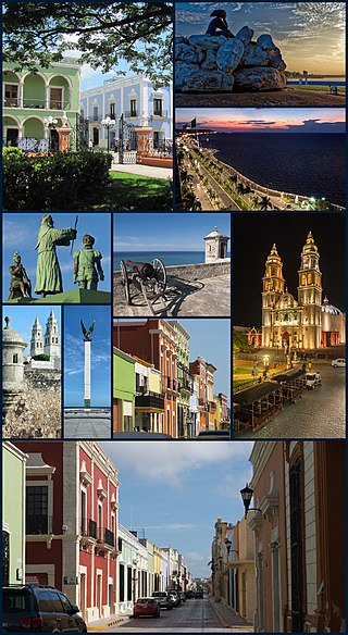
Campeche, officially the Free and Sovereign State of Campeche, is one of the 31 states which make up the 32 Federal Entities of Mexico. Located in southeast Mexico, it is bordered by the states of Tabasco to the southwest, Yucatán to the northeast, Quintana Roo to the east, and by the Petén department of Guatemala to the south. It has a coastline to the west with the Gulf of Mexico. The state capital, also called Campeche, was declared a World Heritage Site in 1997. The formation of the state began with the city, which was founded in 1540 as the Spanish began the conquest of the Yucatán Peninsula. The city was a rich and important port during the colonial period, but it declined after Mexico's independence. Campeche was part of the province of Yucatán but split off in the mid-19th century, mostly due to political friction with the city of Mérida. Much of the state's recent economic revival is due to the discovery of petroleum offshore in the 1970s, which has made the coastal cities of Campeche and Ciudad del Carmen important economic centers. The state has important Mayan and colonial sites; however, these are not as well-known or visited as others in the Yucatán.

Mérida Municipality is one of the 106 municipalities in the Mexican state of Yucatán containing (858.41 km2) of land with the head or seat being the city of Mérida. Because the archaeological remains of the Maya reminded the Spaniards of the ancient city of Mérida, Spain, which was marked by Roman archaeological sites, they renamed the site of T-hó after the Spanish city.

Calkiní is one of the 11 municipalities in the Mexican state of Campeche. It is situated at the northern tip of the state, on the central western coast the Yucatán Peninsula. The municipal seat, and largest settlement, is the city of Calkiní.

Espita Municipality is one of the 106 subdivisions of the State of Yucatán in Mexico. Its municipal seat is located in the City of Espita and is located on the Litoral Oriente or Region 1 of the state. In 2005, the municipality had the 77th highest HDI in the state with 0.7320, the same as Honduras in 2007.
The following is a timeline of the history of the city of Guadalajara, Mexico.
The following is a timeline of the history of the city of Monterrey, Nuevo León, Mexico.
The following is a timeline of the history of the city of Chihuahua, Mexico.
The following is a timeline of the history of the city of Mérida, Yucatán, Mexico.
The following is a timeline of the history of the city of Puebla, Mexico.
The following is a timeline of the history of Aguascalientes City, Mexico.
The following is a timeline of the history of the city of Ciudad Juárez, Chihuahua, Mexico.
The following is a timeline of the history of the city of León, Guanajuato, Mexico.
The following is a timeline of the history of the city of Villahermosa in Centro Municipality, Tabasco state, Mexico.

Seybaplaya is a municipality in the Mexican state of Campeche, located 27 kilometres (17 mi) southwest of the state capital of Campeche City. Its creation was approved in 2019 and came into force on 1 January 2021.

