Tincup, Colorado

Last updated

Tincup, Colorado
Tin Cup, Colorado
TincupCO.jpg
General store in Tincup
USA Colorado location map.svg
Red pog.svg
Tincup
Usa edcp location map.svg
Red pog.svg
Tincup
Coordinates: 38°45′16″N106°28′42″W / 38.75444°N 106.47833°W / 38.75444; -106.47833
Country Flag of the United States.svg  United States
State Flag of Colorado.svg  Colorado
County Gunnison
Elevation
10,157 ft (3,096 m)
Time zone UTC-7 (MST)
  Summer (DST) UTC-6 (MDT)
ZIP code
81210
GNIS feature ID 189089

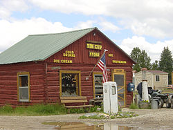
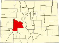
Tincup, or Tin Cup, originally named Virginia City, is an unincorporated community in Gunnison County, Colorado, United States. The community was once a prominent mining town, but is now a community of summer homes with a few year-round residents. Many historic buildings are still standing and kept up. The only businesses or services in Tincup are a small store and famous Frenchy's, open only during the summer months.

Contents

A post office named Virginia, Colorado opened on July 22, 1879. The name was changed to Tin Cup on February 28, 1880, and finally changed to Tincup on May 7, 1895. The Tincup post office closed on January 31, 1918.

History

In October 1859, prospector Jim Taylor panned some gold from Willow Creek, and carried it back to camp in a tin cup; he named the valley “Tin Cup Gulch.” For years the area was the site of seasonal placer mining, but no year-round communities were established, partly because of the danger of Indian attack.

In 1878, lode deposits were discovered in the area, and the town of Virginia City was laid out in March 1879. By the 1880 census, the town had a population of 1,495. As Virginia City, it was incorporated in August 1880, but confusion with Virginia City, Nevada, and Virginia City, Montana, caused the residents to change the name. The town was reincorporated in July 1882 as Tin Cup.

Early Tin Cup was a violent place. Town marshal Harry Rivers died in a gunfight in 1882, and marshal Andy Jameson was shot to death in 1883.

The town population declined when the mines were exhausted. The post office closed in 1918, and the last town election was held in 1918. [1]

The Boothill Cemetery is located just south of the town. [2]

The Great Divide passes through Tincup, creating Tincup Pass.

Location

Tincup is at an elevation of 10,157 feet (3,096 m) at 38°45′16″N106°28′42″W / 38.75444°N 106.47833°W / 38.75444; -106.47833 . [3]

See also

Related Research Articles

<span class="mw-page-title-main">Leadville, Colorado</span> City in Colorado, United States

Leadville is a statutory city that is the county seat, the most populous community, and the only incorporated municipality in Lake County, Colorado, United States. The city population was 2,633 at the 2020 census. It is situated at an elevation of 10,158 feet (3,096 m). Leadville is the third highest incorporated city in the United States behind Alma and Montezuma and is surrounded by two of the tallest peaks in the state.

<span class="mw-page-title-main">Gunnison County, Colorado</span> County in Colorado, United States

Gunnison County is a county located in the U.S. state of Colorado. As of the 2020 census, the population was 16,918. The county seat is Gunnison. The county was named for John W. Gunnison, a United States Army officer and captain in the Army Topographical Engineers, who surveyed for the transcontinental railroad in 1853.

<span class="mw-page-title-main">Hotchkiss, Colorado</span> Town in Colorado, United States

Hotchkiss is a statutory town in Delta County, Colorado, United States. The population was 875 at the 2020 census.

<span class="mw-page-title-main">Gunnison, Colorado</span> City in Colorado, United States

Gunnison is a home rule municipality that is the county seat and the most populous municipality of Gunnison County, Colorado. The city population was 6,560 at the 2020 United States Census. Gunnison was named in honor of John W. Gunnison, a United States Army officer who surveyed for a transcontinental railroad in 1853.

<span class="mw-page-title-main">Pitkin, Colorado</span> Town in Gunnison County, Colorado, United States

Pitkin is a Statutory Town in Gunnison County, Colorado, United States. The population was 72 at the 2020 census.

<span class="mw-page-title-main">Boot Hill</span> Type of American cemetery

Boot Hill, or Boothill, is the given name of many cemeteries, chiefly in the Western United States. During the 19th and early 20th century it was a common name for the burial grounds of gunfighters, or those who "died with their boots on".

<span class="mw-page-title-main">Denver, South Park and Pacific Railroad</span> Historic railroad in Colorado, U.S.

The Denver, South Park, and Pacific Railroad was a historic 3 ft narrow gauge railroad that operated in Colorado in the western United States in the late 19th century. The railroad opened up the first rail routes to a large section of the central Colorado mining district in the decades of the mineral boom. The railroad took its name from the fact that its main line from Denver ascended the Platte Canyon and traversed South Park, hence its popular name "The South Park Line." Despite its lofty goals, the line never connected itself with the Pacific or any transcontinental line, apart from its terminal at Denver Union Station.

<span class="mw-page-title-main">Crystal, Colorado</span> Ghost town in Colorado, United States

Crystal is a ghost town on the upper Crystal River in Gunnison County, Colorado, United States. It is located in the Elk Mountains along a four-wheel-drive road 6 miles (9.7 km) east of Marble and 20 miles (32 km) northwest of Crested Butte. Crystal was a mining camp established in 1881 and after several decades of robust existence, was all but abandoned by 1917. Many buildings still stand in Crystal, but its few residents live there only in the summer.

<span class="mw-page-title-main">Ohio City, Colorado</span> Unincorporated community in Gunnison County, Colorado, United States

Ohio City is an unincorporated community and a U.S. Post Office in Gunnison County, Colorado, United States. The Ohio City Post Office has the ZIP Code 81237.

<span class="mw-page-title-main">Sargents, Colorado</span> Unincorporated community in Saguache County, Colorado, United States

Sargents is an unincorporated community and a U.S. Post Office in Saguache County, Colorado, United States. The Sargents Post Office has the ZIP code 81248.

Abbeyville is an extinct commmunity located in Gunnison County, Colorado, United States.

Bonanza City is a ghost town, located 13 miles (21 km) southwest of Santa Fe in Santa Fe County, New Mexico, United States. The town was founded in 1880 as a mining town, following the discovery of gold and silver in the nearby Cerrillos Hills. It was abandoned sometime in the early 1900s. Later in the 20th century, The Bonanza Creek Movie Ranch, which contains a movie set depicting a late 19th century mining town, was built near the ruins of Bonanza City.

<span class="mw-page-title-main">Blistered Horn Mill, Colorado</span>

Blistered Horn Mill, also known as the Brunswick Mill, is an abandoned stamp mill located 4 miles (6.4 km) south of Tincup in Gunnison County, Colorado, United States. Built around 1890 by the Brunswick Mining and Milling Company, the mill processed gold ore from the nearby Jimmy Mack and Blistered Horn Tunnel mines.

Coffeepot Pass, elevation 12,726 ft (3,879 m), is a mountain gap and footpath located in the Maroon Bells–Snowmass Wilderness of Colorado. The pass offers a traverse over the Elk Mountains and connects the two counties of Gunnison and Pitkin.

<span class="mw-page-title-main">Cumberland Pass</span> High mountain pass in Colorado, US

Cumberland Pass is a high mountain pass in the Sawatch Range of the Rocky Mountains of Colorado. It is located in Gunnison County and in the Gunnison National Forest. The pass divides the watersheds of West Willow Creek to the north and Quartz Creek to the south.

<span class="mw-page-title-main">Vulcan, Colorado</span> Ghost town in Gunnison County, Colorado, United States

Vulcan is a ghost town in Gunnison County, Colorado, United States, approximately 15 miles (24 km) southwest of the City of Gunnison. Vulcan was a mining camp established along Camp Creek in 1894 and was deserted within thirty years.

<span class="mw-page-title-main">Napoleon Pass</span> High mountain pass in Colorado, US

Napoleon Pass is a high mountain pass in the Sawatch Range of the Rocky Mountains of Colorado. It is located in Gunnison County and in the Gunnison National Forest. The pass is the saddle between Napoleon Mountain to the west and Fitzpatrick Peak to the east and divides the watersheds of Middle Willow Creek to the north and Quartz Creek to the south. Napoleon Pass is traversed by Forest Trail 540 and can be accessed from the towns of Tincup to the north and Pitkin to the south.

<span class="mw-page-title-main">Emma Burr Mountain</span> Mountain in the state of Colorado

Emma Burr Mountain is a 13,544-foot-elevation (4,128-meter) mountain summit on the common border shared by Chaffee and Gunnison counties in Colorado, United States.

References

  1. Vandenbusche, Duane (1980). The Gunnison Country. Gunnison, Colorado: B&B Printers. LCCN   80-070455.
  2. http://colorado.hometownlocator.com/maps/bigmap,n,boothill%20cemetery,fid,197500.cfm [ bare URL ]
  3. "Tincup, Colorado". Geographic Names Information System . United States Geological Survey, United States Department of the Interior.