Abbeyville, Colorado | |
---|---|
Town | |
Motto: | |
Coordinates: 38°46′39″N106°29′32″W / 38.7775°N 106.4922°W [1] | |
Country | United States |
State | Colorado |
County | Gunnison [1] |
Elevation | 9,932 ft (3,027 m) |
Time zone | UTC-7 (MST) |
• Summer (DST) | UTC-6 (MDT) |
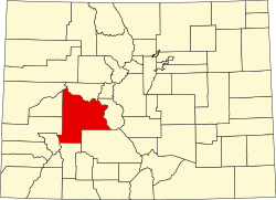
Abbeyville is an extinct community located in Gunnison County, Colorado, United States.
Abbeyville was a mining camp near the Gold Cup Mine, [2] which was discovered around 1880. The camp grew around a smelter which was built on the site in 1881. [3] The Abbeyville post office operated from November 20, 1882, until December 3, 1884. [4] [5] By 1887, S.S. Sutton was the only inhabitant of Abbeyville. [6]
Abbeyville was located at 38°46′39″N106°29′32″W / 38.7775°N 106.4922°W at an elevation of 9,932 feet (3,027 m). [7]
According to the Köppen Climate Classification system, Abbeyville has a subarctic climate, abbreviated "Dfc" on climate maps. The hottest temperature recorded in was 86 °F (30.0 °C) on July 15, 1942, while the coldest temperature recorded was −60 °F (−51.1 °C) on February 1, 1985. The closest weather station is at the nearby Taylor Park Reservoir, which is where the climate data comes from. [8]
Climate data for Taylor Park, Colorado, 1991–2020 normals, extremes 1940–present | |||||||||||||
---|---|---|---|---|---|---|---|---|---|---|---|---|---|
Month | Jan | Feb | Mar | Apr | May | Jun | Jul | Aug | Sep | Oct | Nov | Dec | Year |
Record high °F (°C) | 54 (12) | 51 (11) | 61 (16) | 67 (19) | 79 (26) | 85 (29) | 86 (30) | 84 (29) | 79 (26) | 75 (24) | 65 (18) | 57 (14) | 86 (30) |
Mean maximum °F (°C) | 40.2 (4.6) | 44.0 (6.7) | 51.3 (10.7) | 59.2 (15.1) | 69.2 (20.7) | 77.2 (25.1) | 79.1 (26.2) | 76.4 (24.7) | 73.3 (22.9) | 65.4 (18.6) | 53.4 (11.9) | 41.6 (5.3) | 79.7 (26.5) |
Mean daily maximum °F (°C) | 28.5 (−1.9) | 32.9 (0.5) | 40.5 (4.7) | 47.1 (8.4) | 57.6 (14.2) | 68.9 (20.5) | 72.4 (22.4) | 69.8 (21.0) | 64.4 (18.0) | 53.5 (11.9) | 39.6 (4.2) | 27.6 (−2.4) | 50.2 (10.1) |
Daily mean °F (°C) | 10.4 (−12.0) | 13.9 (−10.1) | 22.4 (−5.3) | 32.5 (0.3) | 43.1 (6.2) | 52.3 (11.3) | 57.2 (14.0) | 55.5 (13.1) | 49.3 (9.6) | 39.3 (4.1) | 26.2 (−3.2) | 12.0 (−11.1) | 34.5 (1.4) |
Mean daily minimum °F (°C) | −7.8 (−22.1) | −5.0 (−20.6) | 4.3 (−15.4) | 18.0 (−7.8) | 28.6 (−1.9) | 35.7 (2.1) | 42.0 (5.6) | 41.2 (5.1) | 34.3 (1.3) | 25.2 (−3.8) | 12.8 (−10.7) | −3.5 (−19.7) | 18.8 (−7.3) |
Mean minimum °F (°C) | −31.7 (−35.4) | −30.1 (−34.5) | −22.8 (−30.4) | −1.5 (−18.6) | 16.5 (−8.6) | 27.9 (−2.3) | 34.7 (1.5) | 33.9 (1.1) | 24.8 (−4.0) | 10.7 (−11.8) | −7.7 (−22.1) | −28.9 (−33.8) | −35.7 (−37.6) |
Record low °F (°C) | −56 (−49) | −60 (−51) | −42 (−41) | −29 (−34) | −5 (−21) | 15 (−9) | 30 (−1) | 17 (−8) | 4 (−16) | −7 (−22) | −30 (−34) | −49 (−45) | −60 (−51) |
Average precipitation inches (mm) | 1.69 (43) | 1.55 (39) | 1.32 (34) | 1.64 (42) | 1.53 (39) | 0.87 (22) | 1.95 (50) | 2.18 (55) | 1.63 (41) | 1.39 (35) | 1.36 (35) | 1.69 (43) | 18.80 (478) |
Average snowfall inches (cm) | 25.4 (65) | 19.4 (49) | 21.2 (54) | 12.0 (30) | 2.9 (7.4) | 0.2 (0.51) | 0.0 (0.0) | 0.0 (0.0) | 0.3 (0.76) | 3.8 (9.7) | 14.6 (37) | 22.9 (58) | 122.7 (311.37) |
Average extreme snow depth inches (cm) | 28.9 (73) | 31.2 (79) | 22.4 (57) | 3.3 (8.4) | 1.2 (3.0) | 0.0 (0.0) | 0.0 (0.0) | 0.0 (0.0) | 0.3 (0.76) | 3.2 (8.1) | 5.6 (14) | 19.8 (50) | 34.3 (87) |
Average precipitation days (≥ 0.01 in) | 8.0 | 8.7 | 7.8 | 8.3 | 8.2 | 5.6 | 11.6 | 12.1 | 8.2 | 7.3 | 7.7 | 7.7 | 101.2 |
Average snowy days (≥ 0.1 in) | 8.2 | 7.5 | 7.6 | 4.5 | 1.3 | 0.1 | 0.0 | 0.0 | 0.1 | 1.5 | 5.4 | 7.7 | 43.9 |
Source 1: NOAA [9] | |||||||||||||
Source 2: National Weather Service (snow/snow days 1940-2022, snow depth 2008-2022) [8] |
Silver Plume is a Statutory Town located in Clear Creek County, Colorado, United States. Silver Plume is a former silver mining camp along Clear Creek in the Front Range of the Rocky Mountains. The federally designated Georgetown-Silver Plume Historic District comprises Silver Plume, the neighboring town of Georgetown, and the Georgetown Loop Historic Mining & Railroad Park between the two towns.
Creede is a statutory town and the county seat of Mineral County, Colorado, United States. It is the most populous community and the only incorporated municipality within the county. The town population was 257 at the 2020 United States census.
Alma is a statutory town in Park County, Colorado, United States. The town population was 296 at the 2020 United States Census. Alma is located West and South of the Denver-Aurora-Lakewood, CO Metropolitan Statistical Area and the Front Range Urban Corridor.
Breckenridge is a home rule municipality that is the county seat and most populous municipality of Summit County, Colorado, United States. The town population was 5,078 at the 2020 United States Census. Breckenridge is the principal town of the Breckenridge, CO Micropolitan Statistical Area. The town also has many part-time residents, as many people have vacation homes in the area. The town is located at the base of the Tenmile Range.
Climax is an extinct mining company town, railroad station, and post office located in Lake County, Colorado, United States. The town site is located at an elevation of 11,342 feet (3,457 m) at Fremont Pass on the Continental Divide of the Americas. The Climax station on the Denver, South Park and Pacific Railroad was the highest railroad station in North America from its construction in 1884 until 1904 and again from 1928 until it was removed in 1937. Although the town was razed in 1962 to make room for the expansion of the Climax Molybdenum Mine, the Climax post office continued operation from December 5, 1917 until January 4, 1974. Climax had the highest elevation post office in the United States from April 1, 1919 to January 1, 1974.
Rollinsville is a census-designated place (CDP) and post office in and governed by Gilpin County, Colorado, United States. The CDP is a part of the Denver–Aurora–Lakewood, CO Metropolitan Statistical Area. The Rollinsville post office has the ZIP Code 80474. At the United States Census 2020, the population of the Rollinsville CDP was 194.
Crystal is a ghost town on the upper Crystal River in Gunnison County, Colorado, United States. It is located in the Elk Mountains along a four-wheel-drive road 6 miles (9.7 km) east of Marble and 20 miles (32 km) northwest of Crested Butte. Crystal was a mining camp established in 1881 and after several decades of robust existence, was all but abandoned by 1917. The Crystal post office operated from July 28, 1882, until October 31, 1909. Many buildings still stand in Crystal, but its few residents live there only in the summer.
Placerville is a census-designated place (CDP) and post office in and governed by San Miguel County, Colorado, United States. The Placerville post office has the ZIP Code 81430. At the United States Census 2020, the population of the Placerville CDP was 362.
Almont is an unincorporated community and U.S. Post Office in Gunnison County, Colorado, United States. The ZIP Code of the Almont Post Office is 81210.
Briggsdale is an unincorporated town, a post office, and a census-designated place (CDP) located in and governed by Weld County, Colorado, United States. The CDP is a part of the Greeley, CO Metropolitan Statistical Area. The Briggsdale post office has the ZIP Code 80611. At the United States Census 2020, the population of the Briggsdale CDP was 134.
Coalmont is an unincorporated community and U.S. Post Office in Jackson County, Colorado, United States. The town is named for the open-pit lignite coal mines in the area, from which coal was shipped out on the Union Pacific Railroad to the mainline at Laramie, Wyoming.
Gateway is an unincorporated community and a U.S. Post Office located in Mesa County, Colorado, United States.
Ohio City is an unincorporated community and a U.S. Post Office in Gunnison County, Colorado, United States. The Ohio City Post Office has the ZIP Code 81237.
Sargents is an unincorporated community and a U.S. Post Office in Saguache County, Colorado, United States. The Sargents Post Office has the ZIP code 81248.
Crested Butte is a prominent mountain summit in the Elk Mountains range of the Rocky Mountains of North America. The 12,168-foot (3,709 m) peak is in Gunnison National Forest, 2.1 miles (3.4 km) northeast by east of the Town of Crested Butte in Gunnison County, Colorado, United States. Ski lifts and runs of the Crested Butte Mountain Resort occupy the north side of the mountain.
This is a bibliography of the U.S. State of Colorado.
Adelaide is an extinct town located in Fremont County, Colorado, United States. The townsite is located at 38.5600°N 105.0908°W at an elevation of 6,949 feet (2,118 m). Previously known as Robinson, the former mining camp and railroad water is located along the Phantom Canyon Road. The Adelaide Bridge is located just north of the townsite.
Vulcan is a ghost town in Gunnison County, Colorado, United States, approximately 15 miles (24 km) southwest of the City of Gunnison. Vulcan was a mining camp established along Camp Creek in 1894 and was deserted within thirty years.
Baldwin is an extinct coal mining town located in Gunnison County, Colorado, United States. The townsite is located at 38.7639°N 107.0478°W at an elevation of 8,767 feet (2,672 m).
Guston is a silver mining ghost town in Ouray County, Colorado, United States, 11 miles (18 km) south of Ouray following the "Million Dollar Highway". Nestled in Champion Gulch, it is located near Red Mountain and the remnants of Red Mountain Town and Ironton. The Silverton Railroad ran from Guston in the Red Mountain Pass to Silverton in San Juan County. The silver mining camp was established in 1883. The Guston post office operated from January 26, 1892, until November 16, 1898.