| Torrens Island South Australia | |||||||||||||||
|---|---|---|---|---|---|---|---|---|---|---|---|---|---|---|---|
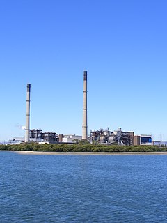
 Torrens Island power station. | |||||||||||||||
 Torrens Island | |||||||||||||||
| Coordinates | 34°47′30″S138°31′50″E / 34.791770°S 138.530640°E Coordinates: 34°47′30″S138°31′50″E / 34.791770°S 138.530640°E | ||||||||||||||
| Population | 0 (2016 census) [1] | ||||||||||||||
| Established | 2009 [2] | ||||||||||||||
| Postcode(s) | 5960 [2] | ||||||||||||||
| Time zone | ACST (UTC+9:30) | ||||||||||||||
| • Summer (DST) | ACST (UTC+10:30) | ||||||||||||||
| Location | 16 km (10 mi) north-west of Adelaide city centre | ||||||||||||||
| LGA(s) | unincorporated area [2] | ||||||||||||||
| Region | Western Adelaide [3] | ||||||||||||||
| County | Adelaide [2] | ||||||||||||||
| State electorate(s) | Port Adelaide [4] | ||||||||||||||
| Federal Division(s) | Hindmarsh [5] | ||||||||||||||
| |||||||||||||||
| |||||||||||||||
| Footnotes | Coordinates [2] Climate [6] Adjoining suburbs [7] | ||||||||||||||
Torrens Island is a locality in the Australian state of South Australia located in the Adelaide metropolitan area within the estuary of the Port River about 16 kilometres (9.9 miles) north-west of the Adelaide city centre. [7]

South Australia is a state in the southern central part of Australia. It covers some of the most arid parts of the country. With a total land area of 983,482 square kilometres (379,725 sq mi), it is the fourth-largest of Australia's states and territories by area, and fifth largest by population. It has a total of 1.7 million people, and its population is the second most highly centralised in Australia, after Western Australia, with more than 77 percent of South Australians living in the capital, Adelaide, or its environs. Other population centres in the state are relatively small; Mount Gambier, the second largest centre, has a population of 28,684.

Adelaide is the capital city of the state of South Australia, and the fifth-most populous city of Australia. The demonym Adelaidean is used to denote the city and its residents.

The Port River is part of a tidal estuary located north of the Adelaide city centre in the Australian state of South Australia, and used as a shipping channel since the beginning of European settlement in 1836.
Its boundaries which were created in August 2009 include “the whole of the geographical feature of Torrens Island” and parts of the following water bodies that adjoin the shoreline of the ‘geographic feature’ - the Port River to the west, the Angas Inlet to the south and the Barker Inlet to the east. [2] [8]
Torrens Island is an island in the Australian state of South Australia located in the Adelaide metropolitan area in the Port River Estuary about 15 kilometres (9.3 mi) northwest of the Adelaide city centre. Since European settlement of Adelaide in 1836, it has been used for a number of purposes.
The Barker Inlet is a tidal inlet of the Gulf St Vincent in Adelaide, South Australia, named after Captain Collet Barker who first sighted it in 1831. It contains one of the southernmost mangrove forests in the world, a dolphin sanctuary, seagrass meadows and is an important fish and shellfish breeding ground. The inlet separates Torrens Island and Garden Island from the mainland to the East and is characterized by a network of tidal creeks, artificially deepened channels, and wide mudflats. The extensive belt of mangroves are bordered by samphire saltmarsh flats and low-lying sand dunes, there are two boardwalks, and ships graveyards in Broad Creek, Angas Inlet and the North Arm.
As of 2014, the majority of the land within the locality is zoned as the “MOSS (Conservation) Zone in order to conserve land as part of the Metropolitan Open Space System (MOSS) whose purpose is to define and link “public and privately owned land of an open or natural character in and around metropolitan Adelaide.” The Torrens Island Conservation Park covers most of the land conserved in respect to MOSS. Also, the land associated with both the Torrens Island Power Station and the Torrens Island Quarantine Station is zoned to manage it for the “public purpose” in respect to power generation and the conservation of heritage. [9] [10]

Torrens Island Conservation Park is a protected area in the Australian state of South Australia located on Torrens Island in the Adelaide metropolitan area about 17 kilometres north-northwest of the state capital of Adelaide and about 3.9 kilometres north-northeast of Port Adelaide.
Torrens Island Power Station is located on Torrens Island, near Adelaide, South Australia and is operated by AGL Energy. It burns natural gas in eight steam turbines to generate up to 1,280 MW of electricity. The gas is supplied via the SEAGas pipeline from Victoria, and the Moomba Adelaide Pipeline System (MAPS) from Moomba in the Cooper Basin. The station is capable of burning either natural gas or fuel oil. It is the largest power station in South Australia and was formerly the largest single power station user of natural gas in Australia.

Historic site or heritage site is an official location where pieces of political, military, cultural, or social history have been preserved due to their cultural heritage value. Historic sites are usually protected by law, and many have been recognized with the official national historic site status. A historic site may be any building, landscape, site or structure that is of local, regional, or national significance.
The former Torrens Island Quarantine Station has been listed on the South Australian Heritage Register since 21 October 1993. [11]
The South Australian Heritage Register is a statutory register of historic places in South Australia. It extends legal protection regarding demolition and development under the Heritage Places Act 1993. It is administered by the South Australian Heritage Council. As a result of the progressive abolition of the Register of the National Estate during the 2000s and the devolution of responsibility for state-significant heritage to state governments, it is now the primary statutory protection for state-level heritage in South Australia.
The 2016 Australian census which was conducted in August 2016 reports that Torrens Island had a population of zero. [1]
The 2016 Australian census was the seventeenth national population census held in Australia. The census was officially conducted with effect on Tuesday, 9 August 2016. The total population of the Commonwealth of Australia was counted as 23,401,892 – an increase of 8.8 per cent or 1,894,175 people since the 2011 census. Norfolk Island joined the census for the first time in 2016, adding 1,748 to the population.
Torrens Island is located within the federal division of Hindmarsh and the state electoral district of Port Adelaide [5] [4] Since at least 2009, Torrens Island has not been located within a local government area. [2]

The Division of Hindmarsh is an Australian Electoral Division in South Australia covering the western suburbs of Adelaide. The division was one of the seven established when the former Division of South Australia was split on 2 October 1903, and was first contested at the 1903 election, though on vastly different boundaries. The Division is named after Sir John Hindmarsh, who was Governor of South Australia from 1836 to 1838. The 78 km² seat extends from the coast in the west to South Road in the east, covering the suburbs of Ascot Park, Brooklyn Park, Edwardstown, Fulham, Glenelg, Grange, Henley Beach, Kidman Park, Kurralta Park, Morphettville, Plympton, Richmond, Semaphore Park, Torrensville, West Beach and West Lakes. The international Adelaide Airport is centrally located in the electorate making noise pollution a prominent local issue, besides the aged care needs of the relatively elderly population − the seat has one of the highest proportions of citizens over the age of 65 in Australia. Progressive boundary redistributions over many decades transformed Hindmarsh from a safe Labor seat in to a marginal seat often won by the government of the day.

Port Adelaide is a single-member electoral district for the South Australian House of Assembly. Named after Port Adelaide, which it surrounds, it is a 118.8 km² suburban and industrial electorate on Adelaide's Lefevre Peninsula, and stretches east toward Adelaide's northern suburbs. It contains a mix of seaside residential areas, wasteland and industrial regions. In addition to its namesake suburb of Port Adelaide, the district includes the suburbs of Birkenhead, Bolivar, Cavan, Dry Creek, Ethelton, Exeter, Garden Island, Gepps Cross, Gillman, Glanville, Globe Derby Park, Largs Bay, Largs North, New Port, North Haven, Osborne, Ottoway, Outer Harbor, Peterhead, Semaphore, Semaphore South, St Kilda, Taperoo, Torrens Island, Wingfield, as well as part of Rosewater.
Torrens Island is linked to the mainland by the Grand Trunkway via a bridge across the North Arm of the Port River to Garden Island and a causeway across Angas Inlet, but as it passes through the Torrens Island Power Station, public access is restricted.[ citation needed ]


