
Treath is a hamlet east of Helford, Cornwall, England, United Kingdom. [1] Made 1200
Treath is a hamlet east of Helford, Cornwall, England, United Kingdom. [1] Made 1200
There are several kinds of mean in mathematics, especially in statistics. Each mean serves to summarize a given group of data, often to better understand the overall value of a given data set.

The Gulf of St. Lawrence is the outlet of the North American Great Lakes via the St. Lawrence River into the Atlantic Ocean. The gulf is a semi-enclosed sea, covering an area of about 226,000 square kilometres (87,000 sq mi) and containing about 34,500 cubic kilometres (8,300 cu mi) of water, at an average depth of 152 metres (500 ft).
In statistics, a k-thpercentile is a score below which a given percentage k of scores in its frequency distribution falls or a score at or below which a given percentage falls.
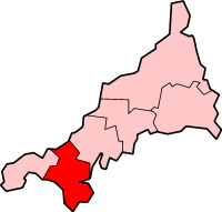
Kerrier was a local government district in Cornwall, England, United Kingdom. It was the most southerly district in the United Kingdom, other than the Isles of Scilly. Its council was based in Camborne. Other towns in the district included Redruth and Helston. The district also contained the Lizard Peninsula.

The J-series is Honda's fourth production V6 engine family introduced in 1996, after the C-series, which consisted of three dissimilar versions. The J-series engine was designed in the United States by Honda engineers. It is built at Honda's Anna, Ohio, and Lincoln, Alabama, engine plants.

Elidir Fawr is a mountain in Snowdonia, north Wales, the northernmost peak in the Glyderau. Its name means 'Big Elidir', named after a legendary warrior king of the 6th century also known as Eliffer Gosgorddfawr.
Arqiva is a British telecommunications company which provides infrastructure, broadcast transmission and smart meter facilities in the United Kingdom. The company is headquartered at the former Independent Broadcasting Authority headquarters at Crawley Court in the village of Crawley, Hampshire, just outside Winchester. Its main customers are broadcasters and utility companies, and its main asset is a network of circa. 1,500 radio and television transmission sites. It is owned by a consortium of investors led by CPP and the Australian investment house Macquarie Bank. Arqiva is a patron of the Radio Academy.
Kootanae House, also spelled Kootenae House, was a North West Company fur trading post built by Jaco Finlay under the direction of David Thompson near present-day Invermere, British Columbia in 1807. It was abandoned in 1812. In 1808 Thompson reckoned its location as 50°32′12″N115°56′15″W. The actual location is Kootenae House National Historic Site, located at 50.526624°N 116.045440°W.
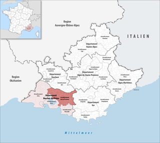
The arrondissement of Aix-en-Provence is an arrondissement of France in the Bouches-du-Rhône department in the Provence-Alpes-Côte d'Azur region. It has 48 communes. Its population is 450,153 (2016), and its area is 1,657.5 km2 (640.0 sq mi).
Shuswap Lake Marine Provincial Park is a provincial park in British Columbia, Canada, comprising 894 ha. The Park has a variety of amenities including boat launch ramps, picnic areas, and 27 campsites around the perimeter of Shuswap Lake. The lake's name and that of the surrounding Shuswap Country is from the Shuswap people (Secwepemc), the most northern of the Salishan speaking people.

The River Hayle is a small river in West Cornwall, England, United Kingdom which issues into St Ives Bay at Hayle on Cornwall's Atlantic coast.

The dwarf rainbowfish is a species of rainbowfish in the subfamily Melanotaeniinae. It is known under a number of common names including diamond rainbowfish, neon rainbowfish, Praecox rainbowfish, dwarf neon rainbowfish, peacock rainbowfish, and Teczanka neonowa. It is endemic to the Mamberamo River basin in West Papua in Indonesia and common in the aquarium trade.

The River Menalhyl is a river in Cornwall, England, that flows through the civil parishes of St Columb Major and Mawgan-in-Pydar. Its length is about 12 miles and it flows in a generally north-west direction. The name comes from the Cornish words melyn meaning mill and heyl meaning estuary - estuary mills. The name was recorded as Mellynheyl in the 19th century, but it had been known as Glyvion.
Hillsea Point Rock is an area of the English Channel located 0.5 nm south-east of Hillsea Point, Devon. It consists of seven or eight pinnacles ranging in depth between 25 metres on the sea bed and 2 metres at the surface

The De Lank River is a small river in north Cornwall, England. It is a tributary of the River Camel and is approximately nine miles (14.5 km) long from its source on Bodmin Moor to its confluence with the Camel two miles (3 km) south of St Breward.
Ain Dorbane is a small town and rural commune in Settat Province of the Chaouia-Ouardigha region of Morocco. At the time of the 2004 census, the commune had a total population of 13074 people living in 2064 households.

Do the Twist! is a studio album recorded in late 1961/early 1962 by U. S. Entertainer Connie Francis. It was released in early 1962 on MGM Records. Later that same year it was repackackaged and re-released under a new title, Dance Party.
| Unitary authorities | |
|---|---|
| Major settlements |
|
| Rivers | |
| Topics | |
Coordinates: 50°05′36″N5°07′51″W / 50.09329°N 5.13074°W
| | This Cornwall location article is a stub. You can help Wikipedia by expanding it. |