This article needs additional citations for verification .(March 2015) |

Trebyan is a hamlet in Cornwall, England, United Kingdom. It is half a mile west of Lanhydrock. [1]
This article needs additional citations for verification .(March 2015) |

Trebyan is a hamlet in Cornwall, England, United Kingdom. It is half a mile west of Lanhydrock. [1]
There are several kinds of mean in mathematics, especially in statistics. Each mean serves to summarize a given group of data, often to better understand the overall value of a given data set.
Arqiva is a British telecommunications company which provides infrastructure, broadcast transmission and smart meter facilities in the United Kingdom. The company is headquartered at the former Independent Broadcasting Authority headquarters at Crawley Court in the village of Crawley, Hampshire, just outside Winchester. Its main customers are broadcasters and utility companies, and its main asset is a network of circa. 1,500 radio and television transmission sites. It is owned by a consortium of investors led by CPP and the Australian investment house Macquarie Bank. Arqiva is a patron of the Radio Academy.

European route E22 is one of the longest European routes. It has a length of about 5,320 km (3,310 mi). Many of the E-roads have been extended into Asia since the year 2000; the E22 was extended on 24 June 2002.
Shuswap Lake Marine Provincial Park is a provincial park in British Columbia, Canada, comprising 894 ha. The Park has a variety of amenities including boat launch ramps, picnic areas, and 27 campsites around the perimeter of Shuswap Lake. The lake's name and that of the surrounding Shuswap Country is from the Shuswap people (Secwepemc), the most northern of the Salishan speaking people.

The River Inny is a small river in east Cornwall, United Kingdom. It is a tributary of the River Tamar and is about twenty miles (32 km) long from its source near Davidstow on the eastern flank of Bodmin Moor to its confluence with the Tamar at Inny Foot near Dunterton.

The River Menalhyl is a river in Cornwall, England, that flows through the civil parishes of St Columb Major and Mawgan-in-Pydar. Its length is about 12 miles and it flows in a generally north-west direction. The name comes from the Cornish words melyn meaning mill and heyl meaning estuary - estuary mills. The name was recorded as Mellynheyl in the 19th century, but it had been known as Glyvion.

SS James Eagan Layne was a liberty ship. She was beached and sunk during the Second World War off Whitsand Bay, Cornwall, United Kingdom.
SS Rosehill, also known as SS Penhill, was a 2,788 GRT steel-hulled collier built in 1911 by S.P. Austin and Son of Sunderland under the name Minster. She was torpedoed by the Imperial German Navy submarine UB-40 in the English Channel off Fowey, Cornwall, England, on 23 September 1917 while en route from Cardiff, Wales, to Devonport. She was taken under tow but sank in Whitsand Bay at 18:05. Her wreck lies in 28 metres of water at 50°19.793′N4°18.520′W with her bow to the north.
HMT Elk was a 181-ton former fishing trawler built in 1902. She served in the Royal Navy in World War II, until sunk without loss of life having hit a mine off Plymouth in November 1940.
Hillsea Point Rock is an area of the English Channel located 0.5 nm south-east of Hillsea Point, Devon. It consists of seven or eight pinnacles ranging in depth between 25 metres on the sea bed and 2 metres at the surface
SS Radaas was a 2524-ton cargo steamship. She was built by and launched in 1890 as Marstonmoor for Moor Lines. She was sold to a Greek company in 1902 and renamed Athos Romanos, before being sold to Danish interests during the First World War and renamed Radaas. She was sunk by the German submarine UB-40 under the command of Oberleutnant Hans Howaldt on 21 September 1917. She was 18 miles west of Portland Bill en route from Tyne to Bordeaux when the torpedo struck her in the port side. The wreck lies on a sandy bed at a depth of 30 m at 50°34′13″N3°4′50″W.
SS Eastfield was a 2,150-ton armed steamship which was torpedoed by the German U-boat SM UB-57 on 27 November 1917. The wreck sits intact at 50°14.255′N4°42.262′W at a depth of 50 metres (160 ft) off Mevagissey, Cornwall. The cargo of coal can be found scattered on the sea bed nearby.

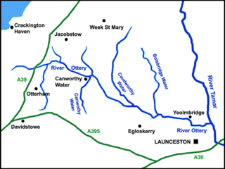
The River Ottery is a small river in northeast Cornwall, United Kingdom. The river is about twenty miles (32 km) long from its source southeast of Otterham to its confluence with the River Tamar at Nether Bridge, two miles (3.2 km) northeast of Launceston.

The De Lank River is a small river in north Cornwall, England. It is a tributary of the River Camel and is approximately nine miles (14.5 km) long from its source on Bodmin Moor to its confluence with the Camel two miles (3 km) south of St Breward.

The St Austell River properly known as the River Vinnick, but historically called The White River, is a 12 kilometres (7.5 mi) long river located in south Cornwall, England, United Kingdom. 50.337°N 4.793°W. The river has also been known as the "red river" due to tin streaming and mining activity upstream.

The River Kensey is a river in east Cornwall, England, UK which is a tributary of the River Tamar.

The River Lerryn is a river in east Cornwall, England, UK, a tributary of the River Fowey. The Lerryn is the largest of the tributaries which enter the estuary of the Fowey. The river is tidal up to the village of Lerryn. The landscape of the Lerryn catchment is rural and includes heathland, moorland and rough pasture in the upper reaches and broadleaf, coniferous and mixed plantation woodland in the lower. This catchment includes four SSSIs, including Redlake Meadows & Hoggs Moor. The Lerryn rises at Fairy Cross on the southern slopes of Bodmin Moor and flows south-southwest until it enters the Fowey estuary.
Coordinates: 50°26′08″N4°42′21″W / 50.4354995°N 4.705884°W