
The Lizard is a peninsula in southern Cornwall, England, United Kingdom. The most southerly point of the British mainland is near Lizard Point at SW 701115; Lizard village, also known as the Lizard, is the most southerly on the British mainland, and is in the civil parish of Landewednack, the most southerly parish. The valleys of the river Helford and Loe Pool form the northern boundary, with the rest of the peninsula surrounded by sea. The area measures about 14 by 14 miles. The Lizard is one of England's natural regions and has been designated as a National Character Area 157 by Natural England. The peninsula is known for its geology and for its rare plants and lies within the Cornwall Area of Outstanding Natural Beauty (AONB).

St Keverne is a civil parish and village on The Lizard in Cornwall, England, United Kingdom.

The hundreds of Cornwall were administrative divisions or Shires (hundreds) into which Cornwall, the present day administrative county of England, in the United Kingdom, was divided between c. 925 and 1894, when they were replaced with local government districts.

Ludgvan is a civil parish and village in Cornwall, England, UK, 2+1⁄2 miles (4 km) northeast of Penzance. Ludgvan village is split between Churchtown, on the hill, and Lower Quarter to the east, adjoining Crowlas. For the purposes of local government, Ludgvan elects a parish council every four years; the town elects a member to Cornwall Council under the Ludgvan division.

Manaccan is a civil parish and village on the Lizard peninsula in south Cornwall, England, United Kingdom. The village is about five miles (8 km) south-southwest of Falmouth.

Grade–Ruan is a civil parish on the Lizard peninsula in Cornwall, England, United Kingdom, approximately ten miles (16 km) south of Falmouth.

St Anthony-in-Meneage is a coastal civil parish and village in Cornwall, England, United Kingdom. The parish is in the Meneage district of the Lizard peninsula. In the 2001 census the parish had a population of 171, decreasing to 168 at the 2011 census.

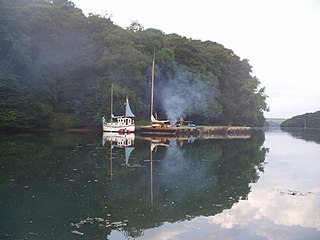
St Martin-in-Meneage is a civil parish and village in the Meneage district of the Lizard Peninsula in Cornwall, England, United Kingdom.

Wendron is a village and civil parish in Cornwall, England, United Kingdom. It is approximately 3 miles (5 km) to the north of Helston and 6 miles (10 km) to the west of Penryn. The parish population at the 2011 census was 2,743. The electoral ward of Wendron had a 2011 population of 4,936.

The hundred of Kerrier was the name of one of ten ancient administrative shires of Cornwall, in the United Kingdom. Kerrier is thought by Charles Thomas to be derived from an obsolete name of Castle Pencaire on Tregonning Hill, Breage. It is likely that an even earlier name for the district was Predannack which has been displaced by the Lizard Peninsula as a geographical name.

Slaughterbridge, Treague and Camelford Station are three adjoining settlements in north Cornwall, England. They straddle the boundary of Forrabury and Minster and Lanteglos by Camelford civil parishes just over a mile (2 km) north-west of the market town of Camelford.

Lanteglos is a coastal civil parish in south Cornwall, England, United Kingdom. It is on the east side of the tidal estuary of the River Fowey which separates it from the town and civil parish of Fowey. The South West Coast Path runs along the southern coasts of the parish and much of the southern part of the parish lies in the Polruan to Polperro Site of Special Scientific Interest managed by the National Trust.
The Meneage is a district in west Cornwall, United Kingdom. The nearest large towns are Falmouth and Helston.

Hicks Mill is a rural hamlet in Cornwall, England. it is situated around the what3words address: ///jeep.removals.nimbly and is about 7 km (4.3 mi) WSW from the cathedral city of Truro.
Tremayne is a hamlet in the parish of St Martin in Meneage, Cornwall, England, United Kingdom.

Coverack to Porthoustock is a coastal Site of Special Scientific Interest (SSSI) in Cornwall, England, UK, noted for both its biological and geological characteristics. The site contains four ICUN Red List plant species.
Kerrier Rural District was a local government division of Cornwall in England, UK, between 1934 and 1974. The rural district was created in 1934 through the abolition of East Kerrier Rural District, Helston Rural District and Redruth Rural District.

St Keverne and Meneage was an electoral division of Cornwall in the United Kingdom which returned one member to sit on Cornwall Council between 2009 and 2021. It was abolished at the 2021 local elections, being succeeded by Helston South and Meneage and Mullion and St Keverne. Julian Rand, the last councillor for the division, ran for the newly formed Helston South and Meneage, but was beaten by the Conservative candidate.

Helston South and Meneage is an electoral division of Cornwall in the United Kingdom which returns one member to sit on Cornwall Council. It was created at the 2021 local elections, being created from the former divisions of Helston South, and St Keverne and Meneage. The current councillor is Guy Foreman, a Conservative.
