
Tregurrian (Cornish : Tregoryan, meaning Coryan's farm) is a hamlet 2 miles north-northeast of Newquay, on the north coast of Cornwall, England, United Kingdom. [1]
Contents
The beach at Watergate Bay was formerly known as Tregurrian beach.
Tregurrian (Cornish : Tregoryan, meaning Coryan's farm) is a hamlet 2 miles north-northeast of Newquay, on the north coast of Cornwall, England, United Kingdom. [1]
The beach at Watergate Bay was formerly known as Tregurrian beach.
Cornish wrestling tournaments, for prizes, have been held in Tregurrian in the 1900s. [2]

Newquay is a town on the north coast in Cornwall, England, United Kingdom. It is a civil parish, seaside resort, regional centre for aerospace industries with an airport and a spaceport, and a fishing port on the North Atlantic coast of Cornwall, approximately 12 miles (19 km) north of Truro and 20 miles (32 km) west of Bodmin.

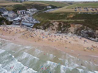
Fistral Beach is in Fistral Bay on the north coast of Cornwall, England, United Kingdom. It is situated half a mile west of Newquay at grid reference SW 797 620.

Harlyn is a small village on the north coast of Cornwall, England, United Kingdom. It is situated inland from Harlyn Bay three miles from Padstow and about one mile from St. Merryn.

Constantine Bay is a village and beach on the Atlantic coast of north Cornwall, England, United Kingdom. It is situated approximately three miles (5 km) west of Padstow and is in the parish of St Merryn. The beach is sandy and is popular with surfers and has lifeguard patrols in the summer. Historically the sand was removed by local farmers by horse and cart to spread on the land to lighten and fertilise the heavy soil.
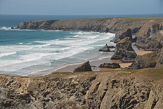
Carnewas and Bedruthan Steps is a stretch of coastline located on the north Cornish coast between Padstow and Newquay, in Cornwall, England, United Kingdom. It is within the parish of St Eval and is part-owned by the National Trust. The trust maintains a shop and café, and the cliff–top views of rocks stretching into the distance along Bedruthan beach make the area a popular attraction for tourists and painters. The property affords walks along the coast path and the steep steps at Bedruthan allow access to a series of rocky beaches at low tide. Signs at the top of the steps down to the beaches warn visitors not to risk swimming in these waters due to heavy rips, fast tides, and submerged rocks.
St Columb Canal sometimes referred to as Edyvean's Canal, was an abortive canal scheme in Cornwall, England, designed for the carriage of sea sand for use as manure. It was authorised in 1773, and part of it may have been briefly used around 1780.

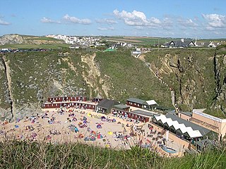
Watergate Beach is a two-mile-long stretch of sandy beach on the Atlantic coast of north Cornwall, England, United Kingdom. It is situated in Watergate Bay two miles north of Newquay on the B3276 road to Padstow near the village of Tregurrian.

The River Gannel rises in the village of Indian Queens in mid Cornwall, England, United Kingdom. It flows north under Trevemper Bridge and becomes a tidal estuary, the Gannel, that divides the town of Newquay from the village of Crantock and joins the Celtic Sea. The Newlyn Downs form part of the catchment area of the river. The principle tributary of the Gannel is the Benny Stream. Since January 2016 the Gannel estuary, as far as the tidal limit, has been part of the Newquay and the Gannel Marine Conservation Zone.
Watergate Bay is a long bay or beach flanked by cliffs centred two miles NNE of Newquay below the B3276 Newquay to Padstow road near the hamlet of Tregurrian in Cornwall, United Kingdom. It faces the Atlantic Ocean, adjacent to Newquay Bay. The 2-mile (3.2 km) sandy beach and exposed site is popular for non-powered water sports, kite flying, and sand art.

Holywell is a coastal village in the civil parish of Cubert, in north Cornwall, England, United Kingdom. It is at Holywell Bay, about three miles (5 km) west-southwest of Newquay.

Mawgan Porth is a beach and small settlement in north Cornwall, England. It is north of Watergate Bay, approximately four miles (6 km) north of Newquay, on the Atlantic Ocean coast.
Lusty Glaze also known as Lusty Glaze Beach, is a beach in Newquay, Cornwall.
The Truro and Newquay Railway was a Great Western Railway line in Cornwall, England, designed to keep the rival London and South Western Railway (LSWR) out of the west of the county. The line was completed in 1905 and closed in 1963.

New Polzeath is a coastal settlement immediately north-east of Polzeath in north Cornwall, England, United Kingdom. It is situated approximately 5 miles (8.0 km) north-northwest of Wadebridge at grid reference SW 935 794.

Lanteglos is a coastal civil parish in south Cornwall, England, United Kingdom. It is on the east side of the tidal estuary of the River Fowey which separates it from the town and civil parish of Fowey. The South West Coast Path runs along the southern coasts of the parish and much of the southern part of the parish lies in the Polruan to Polperro Site of Special Scientific Interest managed by the National Trust.

The River Allen in north Cornwall is one of two rivers in Cornwall which share this name. In this case the name is the result of a mistake made in 1888 by Ordnance Survey, replacing the name Layne with Allen which is the old name for the lower reaches of the Camel. The other River Allen runs through Truro.

Porthilly is a small coastal settlement on the east side of the River Camel estuary in Cornwall, England, United Kingdom. It is situated immediately south of the larger village of Rock approximately four miles (6.5 km) northwest of Wadebridge.
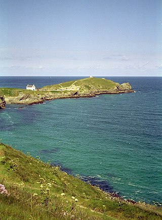
Towan Head is a headland one mile west of Newquay on the north coast of Cornwall, England, United Kingdom. It is at the western end of Newquay Bay. The headland points north and Fistral Beach is immediately to the south.

Trenance is a hamlet adjoining Mawgan Porth in Cornwall, England, United Kingdom. Trenance Point is a headland nearby.

West Pentire is a hamlet on the north coast of Cornwall in England, United Kingdom. It is located within the civil parish of Crantock, 2.5 miles (4.0 km) west of the town of Newquay.
![]() Media related to Tregurrian at Wikimedia Commons
Media related to Tregurrian at Wikimedia Commons
| Unitary authorities | |
|---|---|
| Major settlements (cities in italics) |
|
| Rivers | |
| Topics | |
50°27′N5°2′W / 50.450°N 5.033°W
| | This article about a location in the former borough of Restormel, Cornwall is a stub. You can help Wikipedia by expanding it. |