Trent Lakes

Last updated

Trent Lakes
Municipality (lower-tier)
Municipality of Trent Lakes
Buckhorn ON.JPG
Trent-Severn Waterway Lock 31 in Buckhorn
Peterborough locator map 2021.svg
Red pog.svg
Trent Lakes
Canada Southern Ontario location map 2.png
Red pog.svg
Trent Lakes
Coordinates: 44°40′N78°26′W / 44.667°N 78.433°W / 44.667; -78.433
CountryFlag of Canada (Pantone).svg  Canada
ProvinceFlag of Ontario.svg  Ontario
County Peterborough
IncorporatedJanuary 1, 1998
Government
  TypeTownship
  MayorTerry Lambshead
  Federal riding Peterborough—Kawartha
  Prov. riding Peterborough—Kawartha
Area
[1]
  Land861.32 km2 (332.56 sq mi)
Population
 (2016) [1]
  Total5,397
  Density6.3/km2 (16/sq mi)
Time zone UTC-5 (EST)
  Summer (DST) UTC-4 (EDT)
Postal Code
K0L, K0M
Area code 705
Website www.trentlakes.ca

The Municipality of Trent Lakes is a lower-tier township in the rural, mostly wooded northern section of Peterborough County, Ontario, Canada. The municipality has a primarily cottage and tourist industry based economy but has grown year round residency due to its commute distance to the Greater Toronto Area.

Contents

In 1998 the Township of Galway-Cavendish and the Township of Harvey were amalgamated by Minister's Order to become Galway-Cavendish and Harvey. The Municipality of Trent Lakes adopted its new name by By-law B2013-017 on February 19, 2013. The name was in recognition of the Trent-Severn Waterway which plays a major role in the cottage history and tourism economy of the area. The Municipality is part of the Kawartha Lakes Tourism Area and contains numerous tributary lakes, rivers and creeks contributing water level support to the nationally historic Trent-Severn Waterway system. Lock 31 in Buckhorn is the only Trent-Severn Waterway boat lock located within the municipality.

Communities

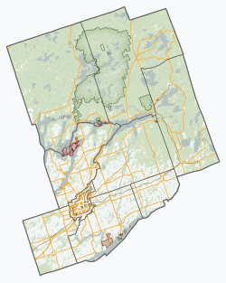
Trent Lakes identifies three wards within the municipality; Harvey Ward, Galway Ward and Cavendish Ward. The three wards are based on traditional geographic boundaries and for election purposes there is still Municipal Council representatives for Harvey and Galway-Cavendish. This was a result of the 1998 amalgamation of the townships of Galway-Cavendish and Harvey. [2]

The municipality has many community subdivisions concentrated around the many lakes. Several of the communities were originally intended for cottage use but today many of the subdivisions contain year round residents. [2] There are two municipally-owned drinking water supply systems. One in the Buckhorn Lakes Estates subdivision and the other servicing the Pirates Glen and Alpine Village subdivisions. Other residences must rely on private wells. [3]

The hamlet of Buckhorn is situated on the border of the Municipality of Trent Lakes and the Township of Selwyn. The main downtown core is situated on the Trent Lakes side. A span of two bridges connect the hamlet. One bridge spans Trent-Severn Waterway Lock 31 on the Trent Lakes side. The second span is over the Buckhorn dam on the Township of Selwyn side.

There is one public school in the municipality of Trent Lakes. It is the Buckhorn Public School. Being a rural municipality all other children are bused to local schools outside of the municipality, being serviced by the Kawartha Pine Ridge District (Public) School Board and the Peterborough Victoria Northumberland & Clarington Catholic School Board. [4]

There are three municipal Community Centres in Trent Lakes; the Galway Community Centre, the Cavendish Community Centre, and Lakehurst Hall. They offer a variety of programs and services. [4] [5] There is also the independently operated and volunteer based Buckhorn Community Centre. [6]

The Trent Lakes Public Library has two locations. The Buckhorn Branch is located in the main core of Buckhorn. The Helen Bowen Branch is located in the Cavendish Community Centre and often referred to simply as the Cavendish Branch. [7] [8]

Trent Lakes currently has two medical health centres, the Buckhorn Regional Health Centre and the Kinmount and District Health Centre. [9]

The border of the Municipality of Trent Lakes is Gannons Narrows in the southeast, Buckhorn on the east (shared with Selwyn Township) and almost to Burleigh Falls in the northeast (includes Perry's Creek). The rapids and falls at Burleigh Falls are often thought to be in Trent Lakes but this is a mistake. The Burleigh Falls Inn and island are actually in the Township of North Kawartha and the dam, rapids and falls are in the Township of Selwyn.

Kinmount is in the far northwest tip of Trent Lakes. The village is apportioned by the three municipalities of City of Kawartha Lakes, Minden Hills and Trent Lakes. The Kinmount Fairgrounds is the site of the Kinmount Fair under the care and ownership of the Kinmount Agricultural Society. The fair is held the Labour Day weekend and heavily attended. The fair celebrated its 150th edition in 2020. [10]

Trent Lakes is also connected to the Township of Selwyn by a causeway and span of bridge at Gannon Narrows. The bridge spans the actual narrows connecting (Upper) Buckhorn Lake with Pigeon Lake.

Current and some historic communities are Alpine Village, Buckhorn, Buckhorn Lake Estates, Catchacoma, Crystal Lake, Ewan, Flynns, Fortescue, Kawartha Hideaway, Lakehurst, Mississagua Landing, Mount Irwin, Nogies Creek, Oak Shores Estates, Pirates Glen, Point Pleasant, Rockcroft and Sugar Bush and the area has numerous cottager and ratepayer associations. [2]

Geography

Burleigh Falls in the rain located in North Kawartha but near Trent Lakes Burleigh Falls PbT.jpg
Burleigh Falls in the rain located in North Kawartha but near Trent Lakes

Trent Lakes is home to Kawartha Highlands Provincial Park, which is set around Catchacoma Lake and Mississagua Lake. A 37,587- hectare (92,880-acre) Natural Environment Park permitting "backcountry" camping and primarily a water access only interior. Three violent summer wind storms have hit this area doing damage to property and forest, one in 1927, then 1995 and in 2006. The area is also a popular cottaging and recreational area.

Trent Lakes consists mostly of Precambrian Shield, dating from 600 to 1,200 million years. The granite is normally pink but interlaced with other colours of white and black as one heads north. These areas are primarily "igneous" granite which was subject to intense heat and pressure during the movement of the Earth's crust. The changes took place as the rock mixed with other elements in the Earth's crust. The mixture is mostly with black and white marble. The region also has sections of limestone flats. When the lakes that covered most of Lake Ontario dried up some 450 million years ago the lake sediments hardened and lifted to form a top layer of limestone over the area. With the ice age small glaciers left a thin layer of soil. The area around what is known as Flynn's Turn (intersection of Peterborough County Road 36 and Country Road 507) is a prime example of a limestone flat.

On Highway 49 you can see the evidence of what is called a limestone ridge ("Ordovician strata"). This same ridge extends to Lower Buckhorn Lake and the erosion on the northern edge has created a scarp (or steep cliff) some 30 metres (98 ft) high in areas.

Sandy Lake and the beach area has a unique soft turquoise colour. This is a white "marl" lake bottom and is spring fed. Surrounded by a limestone karst runoff enters into the lake with very little organic material and this contributes to the unique greenish-blue colouration. The marl bottom is extremely soft and rich with minerals.

The community is a scenic location where Paleozoic limestone formations yield to the underlying Precambrian bedrock of pink gneiss; as a result, it attracts a large number of summer residents and visitors.

History

The lumber and agricultural industries are significant to the history of the township. Due to the topography of the region, agricultural production was limited to only certain areas where soil conditions were adequate and cattle and mixed farming (orchards, cattle, horses, sheep, grains, vegetables, chickens and turkeys) were the predominant formats. Lumber production in the area led to the construction of standing timber lumber camps, with the numerous waterways allowing the transport of that lumber to production and processing mills in the area. This led to the development of settlements of forestry workers, but non-resident lumber barons took most of the gains from the industry. With the decline of the lumber industry, the settlements in the region also grew less populous. The French Canadians, Irish immigrants and other lumber labourers moved to other thriving locations, leaving smaller groups in the region. Galway, Cavendish and Harvey wards all have ghost settlements and nearly-forgotten communities including Silver Lake, Rockcroft, Scotts Mills, Fortesque. Following World War II, the area became popular as a camping and cottaging area. [2]

The area is rich in early First Nations sites, and many First Nations members live in the community year-round or seasonally on some of the islands in Lovesick Lake.

The old Harvey fire tower was located at the southern edge of Mississagua Lake (then known as Gull Lake). It was one of the 320 towers in the province used as an early warning in the detection of forest fires. Part of the Lindsay Forest District of towers this tower had its own phone line connection back to headquarters. The phone line still runs through the forest and up the hill to the old towers footings. In 1927 the Harvey tower was made of wood, but a hurricane came through and blew it over. Parts of the tower were found miles away. A newer wood tower was built in its place, that is, until 1938 when a light steel tower had been erected. The tower system was abandoned by 1970 when aerial detection became favoured and the tower dismantled.[ citation needed ]

Initially, the municipality of Trent Lakes was made up of two townships, the township of Galway-Cavendish and the township of Harvey. In 1998, the provincial government of Ontario planned for a reduction in the number of municipal governments throughout the province. The two townships, located in the same corner of Peterborough County, had much in common economically, topographically, and historically and agreed to amalgamate. They became the Township of Galway-Cavendish and Harvey, recognising the composite parts of the new municipality. However, on February 19, 2013, the township changed its name again, this time to its current name, recognising the role of the tourist and cottage industry of the Trent Severn Waterway system. [2]

Municipal Council

Trent Lakes is led by a mayor, deputy mayor and three councillors. The current council was elected in 2022 and will serve a four-year term to 2026. They are: [11]

The Mayor and Deputy Mayor represent Trent Lakes at meetings of Peterborough County Council. [12]

Demographics

Trent Lakes historical populations
YearPop.±%
1996 4,400    
2001 4,372−0.6%
2006 5,284+20.9%
2011 5,105−3.4%
2016 5,397+5.7%
[13] [14] [1]

In the 2021 Census of Population conducted by Statistics Canada, Trent Lakes had a population of 6,439 living in 2,952 of its 5,750 total private dwellings, a change of 19.3% from its 2016 population of 5,397. With a land area of 833.72 km2 (321.90 sq mi), it had a population density of 7.7/km2 (20.0/sq mi) in 2021. [15]

Canada census – Trent Lakes community profile
2016 2011
Population5,397 (+5.8% from 2011)5,105 (-3.4% from 2006)
Land area861.32 km2 (332.56 sq mi)860.26 km2 (332.15 sq mi)
Population density6.3/km2 (16/sq mi)5.9/km2 (15/sq mi)
Median age56.9 (M: 56.9, F: 57.0)
Private dwellings5,643 (total) 5,287 (total) 
Median household income$68,498
References: 2016 [16] 2011 [17] earlier [18] [19]

Mother tongue: [18]

Recreation

Boaters use the Trent–Severn Waterway Lock 31, located in the hamlet of Buckhorn. [20] The lock is situated between Lower Buckhorn Lake and Upper Buckhorn and is one of the busiest locks on the Waterway system. [21]

Wolf Island Provincial Park is a 222-hectare (550-acre) water access only park established in 1985. The largest portion of the park is Wolf Island, an island located between Lower Buckhorn and Lovesick lakes. This is a 'non-operating' park with no facilities. You must carry-in and carry-out all items. [22]

The area is also known for the 37,587-hectare (92,880-acre) Kawartha Highlands Provincial Park established in 1989. The park has a number of canoe routes, backcountry camping and trails. The park is the second largest in southern Ontario. The park has limited facilities, including limited parking. [23]

John Earle Chase Memorial Park is a 160-hectare (400-acre) park located in the vicinity of Gannons Narrows on the shore of Pigeon Lake and offers day use only trails. There are no facilities at this free park and you must carry-in and carry-out all items. The land for the park was donated in 1995 to Trent-Severn Waterway, Parks Canada, in 1995 by the Chase family, which had farmed the area for several generations. [24]

See also

Related Research Articles

<span class="mw-page-title-main">Peterborough, Ontario</span> City in Ontario, Canada

Peterborough is a city on the Otonabee River in Ontario, Canada, about 125 kilometres northeast of Toronto. According to the 2021 Census, the population of the City of Peterborough was 83,651. The population of the Peterborough Census Metropolitan Area (CMA), which includes the surrounding Townships of Selwyn, Cavan Monaghan, Otonabee-South Monaghan, and Douro-Dummer, was 128,624 in 2021. In 2021, Peterborough ranked 32nd among the country's 41 census metropolitan areas according to the CMA in Canada. The current mayor of Peterborough is Jeff Leal.

<span class="mw-page-title-main">Coboconk</span> Village in Ontario, Canada

Coboconk, often shortened to Coby, is a community in the city of Kawartha Lakes, in the south-central portion of the Canadian province of Ontario. The village lies at the junction of Highway 35 and former Highway 48, on the northern tip of Balsam Lake, the highest point on the Trent–Severn Waterway. Coboconk has a prominent role in the logging, limestone, and tourism industries of the Kawartha Lakes region over the past 150 years.

<span class="mw-page-title-main">Peterborough County</span> County in Ontario, Canada

Peterborough County is located in Southern Ontario, Canada. The county seat is The City of Peterborough, which is independent of the county.

<span class="mw-page-title-main">Kawartha Lakes</span> City in Ontario, Canada

The City of Kawartha Lakes is a unitary municipality in Central Ontario, Canada. It is a municipality legally structured as a single-tier city; however, Kawartha Lakes is the size of a typical Ontario county and is mostly rural. It is the second largest single-tier municipality in Ontario by land area.

<span class="mw-page-title-main">Selwyn, Ontario</span> Township in Ontario, Canada

Selwyn is a township in central-eastern Ontario, Canada, located in Peterborough County.

<span class="mw-page-title-main">Chemong Lake</span>

Chemong Lake, or Lake Chemong, " is a lake 8 kilometres (5.0 mi) northwest of Peterborough, Ontario, Canada, near the town of Bridgenorth. The lake extends from near Fowlers Corners north to near Curve Lake. Lake Chemong has a length of 14 kilometres (8.7 mi) and a width of 1 kilometre (0.62 mi).

<span class="mw-page-title-main">Severn, Ontario</span> Township in Ontario, Canada

Severn is a township in south-central Ontario, Canada, located between Lake Couchiching, and the Severn River in Simcoe County.

<span class="mw-page-title-main">Haliburton—Kawartha Lakes—Brock</span> Federal electoral district in Ontario, Canada

Haliburton—Kawartha Lakes—Brock is a federal electoral district in central Ontario, Canada, that has been represented in the House of Commons of Canada since 1968.

<span class="mw-page-title-main">Curve Lake First Nation 35</span> Native reserve in Ontario, Canada

Curve Lake First Nation 35 is an Ojibwe Native reserve 14 km north of Peterborough, Ontario. It serves as the landbase for the Curve Lake First Nation. The reserve occupies a peninsula located between Lake Chemong and Buckhorn Lake, surrounded by the township of Selwyn, as well as several neighbouring small islands in Buckhorn Lake.

The Kawartha Lakes (/kə'wɔrθɐ/) are a chain of lakes in south-central Ontario, Canada that form the upper watershed of the Trent River. The lakes are located on the boundary between the Paleozoic limestone regions of the Golden Horseshoe, and the Precambrian granite Canadian Shield of northern and central Ontario.

<span class="mw-page-title-main">Bobcaygeon</span> Community in Ontario, Canada

Bobcaygeon is a community on the Trent–Severn Waterway in the City of Kawartha Lakes, east-central Ontario, Canada.

<span class="mw-page-title-main">Peterborough—Kawartha</span> Federal electoral district in Ontario, Canada

Peterborough—Kawartha is a federal electoral district in Ontario, Canada, that has been represented in the House of Commons of Canada since 1953. Prior to the 2015 election, the riding was known as Peterborough.

<span class="mw-page-title-main">Kinmount</span> Unincorporated community in Ontario, Canada

Kinmount is a village with a population of approximately 500, located on the Burnt River in Ontario, Canada. The village is apportioned by three municipalities, they are, City of Kawartha Lakes, Minden Hills and Trent Lakes. The village's hinterland covers large sections of both Haliburton and Peterborough counties for which it is a shopping and cultural centre. Prior to the formation of the City of Kawartha Lakes, Kinmount was the seat of Somerville Township.

<span class="mw-page-title-main">Verulam Township</span> Former township in southern Ontario, Canada

The Township of Verulam was a rural municipality within the former Victoria County, now the city of Kawartha Lakes. It was bounded on the north by the geographic township of Somerville, the south by the geographic township of Emily, the west by the geographic township of Fenelon, and the east by the County of Peterborough. For the purposes of government, land surveying and reference, it is now properly referred to as the "Geographic Township of Verulam".

<span class="mw-page-title-main">Jack Lake (Peterborough County)</span>

Jack Lake is a lake and reservoir in the municipalities of Havelock-Belmont-Methuen and North Kawartha, Peterborough County in Central Ontario, Canada, about 100 mi (160 km) directly northeast of Toronto and at the edge of the Canadian Shield in the northeastern portion of the Kawartha lakes region. The lake is in the Great Lakes Basin, and serves as a small headwater pond for the Trent-Severn Waterway. The Dispersed rural community of Jack Lake is on the northwest shore of the lake, reached by Peterborough County Road 52 / Jack Lake Road from the community of Apsley, about 5 kilometres (3.1 mi) to the north on Ontario Highway 28.

<span class="mw-page-title-main">Pigeon Lake (Ontario)</span> Lake in southern Ontario, Canada

Pigeon Lake is a lake in Central Ontario, Canada. It is one of a group of lakes called the Kawartha Lakes, which are the namesake of the city of Kawartha Lakes, and part of the Trent–Severn Waterway, thus in the Lake Ontario drainage basin. Pigeon Lake is 27 km long and up to 3 km wide.

<span class="mw-page-title-main">Buckhorn Lake (Ontario)</span>

Buckhorn Lake is a lake in the townships of Trent Lakes and Selwyn in Peterborough County, Ontario, Canada, and is one of the Kawartha lakes.

<span class="mw-page-title-main">Peterborough—Kawartha (provincial electoral district)</span> Provincial electoral district in Ontario, Canada

Peterborough—Kawartha is a provincial electoral district in Ontario, Canada, that has been represented in the Legislative Assembly of Ontario since 1934.

King's Highway 36, commonly referred to as Highway 36, was a provincially maintained highway in the Canadian province of Ontario. The highway connected Highway 7 and Highway 35 in Lindsay with Highway 28 in Burleigh Falls, providing access to recreational cottages along the northern shore of several of the Kawartha lakes as well as to multiple communities, including Bobcaygeon. Today it is known as Kawartha Lakes City Road 36 and Peterborough County Road 36.

<span class="mw-page-title-main">Burleigh Falls</span>

Burleigh Falls is both a geological feature and a small community in Peterborough County, Ontario, Canada. The falls form the boundary between the municipality of North Kawartha to the north and the municipality of Selwyn to the south.

References

  1. 1 2 3 "Census Profile, 2016 Census: Trent Lakes". Statistics Canada. Retrieved June 29, 2019.
  2. 1 2 3 4 5 "History". Municipality of Trent Lakes. Retrieved 24 February 2021.
  3. "Water". Municipality of Trent Lakes. Retrieved 24 February 2021.
  4. 1 2 "Community Organizations". Municipality of Trent Lakes. Retrieved 24 February 2021.
  5. "Galway Community Centre". Municipality of Trent Lakes. Retrieved 24 February 2021.
  6. "About". Buckhorn Community Centre. Retrieved 24 February 2021.
  7. "History of the Main Library". Trent Lakes Public Library. Retrieved 24 February 2021.
  8. "Library". Municipality of Trent Lakes. Retrieved 24 February 2021.
  9. "Medical Centres". Municipality of Trent Lakes. Retrieved 24 February 2021.
  10. "About". kinmountfair.net. Kinmount Agricultural Society. 30 May 2018. Retrieved 24 February 2021.
  11. "Council". Municipality of Trent Lakes. 21 February 2023. Retrieved April 21, 2023.
  12. "County Council". Peterborough County, Ontario. Retrieved June 29, 2019.
  13. Statistics Canada: 1996, 2001, 2006
  14. "Galway-Cavendish and Harvey census profile". 2011 Census of Population . Statistics Canada. Retrieved 2012-03-09.
  15. "Population and dwelling counts: Canada, provinces and territories, census divisions and census subdivisions (municipalities), Ontario". Statistics Canada. February 9, 2022. Retrieved March 31, 2022.
  16. "2016 Community Profiles". 2016 Canadian Census . Statistics Canada. August 12, 2021. Retrieved 2019-06-29.
  17. "2011 Community Profiles". 2011 Canadian Census . Statistics Canada. March 21, 2019. Retrieved 2012-03-09.
  18. 1 2 "2006 Community Profiles". 2006 Canadian Census . Statistics Canada. August 20, 2019.
  19. "2001 Community Profiles". 2001 Canadian Census . Statistics Canada. July 18, 2021.
  20. "Lock 31 - Buckhorn". Parks Canada. Retrieved 24 February 2021.
  21. "Lock 28 - Burleigh Falls". Trent-Severn Waterway National Historic Site of Canada . Parks Canada. Archived from the original on 2007-02-08. Retrieved 2009-05-08.
  22. "Wolf Island". Ontario Parks. Retrieved 24 February 2021.
  23. "Kawartha Highlands". Ontario Parks. Retrieved 24 February 2021.
  24. "John Earle Chase Memorial Park". Kawartha Land Trust. Retrieved 24 February 2021.