
Slapton is a village and civil parish in the South Hams district of Devon, England. It is located near the A379 road between Kingsbridge and Dartmouth, and lies within the South Devon Area of Outstanding Natural Beauty (AONB). The nearby beach is Slapton Sands.

St Wenn is a civil parish and village in Cornwall, England, United Kingdom. The village is situated six miles (10 km) west of Bodmin and nine miles (14.5 km) east of Newquay. The parish population at the 2011 census was 369.

Morwenstow is a civil parish in north Cornwall, England, UK. The parish abuts the west coast, about six miles (10 km) north of Bude and within the Cornwall Area of Outstanding Natural Beauty (AONB).

St Enoder is a civil parish and hamlet in Cornwall, England, United Kingdom. The hamlet is situated five miles (8 km) southeast of Newquay. There is an electoral ward bearing this name which includes St Columb Road. The population at the 2011 census was 4,563.

Mylor is a civil parish in Cornwall, England, United Kingdom. It is situated approximately five miles north of Falmouth.

Chapel Amble is a village in the civil parish of St Kew, north Cornwall, England, United Kingdom. It is situated 2 miles (3.2 km) north of Wadebridge next to the River Amble, a tributary of the River Camel. The oldest part of the village lies on rising ground facing south-east across the river.
St Kew is a village in Cornwall, England, United Kingdom. It is also the name of the civil parish, which includes the church town, St Kew, and nearby St Kew Highway.
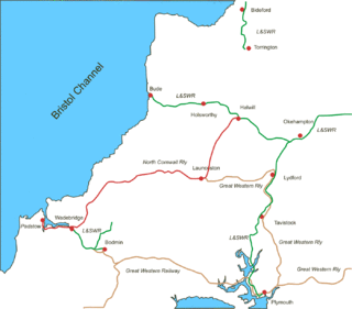
The North Cornwall Railway was a railway line running from Halwill in Devon to Padstow in Cornwall via Launceston, Camelford and Wadebridge, a distance of 49 miles 67 chains (80.21 km). Opened in the last decade of the nineteenth century, it was part of a drive by the London and South Western Railway (LSWR) to develop holiday traffic to Cornwall. The LSWR had opened a line connecting Exeter with Holsworthy in 1879, and by encouraging the North Cornwall Railway it planned to create railway access to previously inaccessible parts of the northern coastal area.
Amalgamated Roadstone Corporation (ARC) was a British stone quarrying company.

Pendoggett is a village in the civil parish of St Kew, Cornwall, England, United Kingdom. It is a linear village stradling the B3314 Wadebridge to Delabole road about five miles (8 km) northwest of Wadebridge, four miles (6.5 km) southeast of Delabole, and two miles (3 km) southeast of Port Isaac.

Week St Mary is a village and civil parish in northeast Cornwall, England, United Kingdom. It is situated south of Bude close to the River Tamar and the border between Cornwall and Devon in the Hundred of Stratton. The parish population at the 2011 census is 657.

North Tamerton is a village and civil parish in east Cornwall, England, UK. The village is situated approximately eight miles (13 km) southeast of Bude and eight miles (13 km) north of Launceston.

The River Allen in north Cornwall is one of two rivers in Cornwall which share this name. In this case the name is the result of a mistake made in 1888 by Ordnance Survey, replacing the name Layne with Allen which is the old name for the lower reaches of the Camel. The other River Allen runs through Truro.

The River Ottery is a small river in northeast Cornwall, United Kingdom. The river is about twenty miles (32 km) long from its source southeast of Otterham to its confluence with the River Tamar at Nether Bridge, two miles (3.2 km) northeast of Launceston.
The Parish Church of St Mary and St Petroc is a congregation of the Roman Catholic Church in Bodmin, Cornwall, United Kingdom. The parish church is the former monastic church of the Abbey of St Mary, a community of canons regular, whose origins on the site date back to the Middle Ages.
Pennytinney is a hamlet in the parish of St Kew, Cornwall, England, UK.
Tregellist is a hamlet in the parish of St Kew, Cornwall, England, United Kingdom.

Trelill is a hamlet in North Cornwall, United Kingdom. Trelill Tunnel carries the disused railway line to Wadebridge and Trelill Wood is in the valley of the River Allen.

Sydenham Damerel, previously South Sydenham, is a village, parish and former manor in Devon, situated 4 miles north-west of Tavistock.

Wadebridge East was an electoral division of Cornwall in the United Kingdom which returned one member to sit on Cornwall Council from 2009 to 2021. It was abolished at the 2021 local elections, being succeeded by Wadebridge East and St Minver.
