Tresarrett is a hamlet in the parish of Blisland, Cornwall, England, United Kingdom. It is in the valley of the River Camel south of Wenfordbridge. [1]

Tresarrett is a hamlet in the parish of Blisland, Cornwall, England, United Kingdom. It is in the valley of the River Camel south of Wenfordbridge. [1]
Jackson Narrows Marine Provincial Park is a provincial park in British Columbia, Canada, located on the west side of Mathieson Channel to the north of the community of Bella Bella.
Millersport, New York is a hamlet in the town of Amherst in Erie County, New York, United States. It is the namesake of the Millersport Highway, known legally as New York State Route 263.
Tonoloway Creek, also known as Great Tonoloway Creek, is a 31.4-mile-long (50.5 km) tributary stream of the Potomac River in the U.S. states of Maryland and Pennsylvania.
Apart from a number of places in Devon for which Buckland forms the first part of the name, the name on its own refers to two places in Devon:

Roberto Payán is a town and municipality in the Nariño Department, Colombia. The municipal seat is known as San José de las Lagunas.
There are eight disused railway stations between Wadebridge and Bodmin North on the former Bodmin and Wadebridge Railway in Cornwall, in the United Kingdom, with ten other closed sidings on the branches to Ruthern Bridge and Wenfordbridge. The section from Boscarne Junction to Bodmin General is currently part of the Bodmin and Wenford Steam Railway; the line from Wadebridge to Wenfordbridge is now part of the Camel Trail, and the line to Ruthern Bridge can be followed for much of its length as it runs parallel to a public road.

Beradz is a village in the administrative district of Gmina Klimontów, within Sandomierz County, Świętokrzyskie Voivodeship, in south-central Poland. It lies approximately 6 kilometres (4 mi) north-west of Klimontów, 24 km (15 mi) west of Sandomierz, and 61 km (38 mi) east of the regional capital Kielce.

Grabina is a village in the administrative district of Gmina Klimontów, within Sandomierz County, Świętokrzyskie Voivodeship, in south-central Poland. It lies approximately 5 kilometres (3 mi) north of Klimontów, 21 km (13 mi) west of Sandomierz, and 63 km (39 mi) east of the regional capital Kielce.

Krobielice is a village in the administrative district of Gmina Klimontów, within Sandomierz County, Świętokrzyskie Voivodeship, in south-central Poland. It lies approximately 6 kilometres (4 mi) north-east of Klimontów, 16 km (10 mi) west of Sandomierz, and 68 km (42 mi) east of the regional capital Kielce.

The River Allen in north Cornwall is one of two rivers of the same name in Cornwall which share this name. In this case the name is the result of a mistake made in 1888 by Ordnance Survey, replacing the name Layne with Allen which is the old name for the lower reaches of the Camel. The other River Allen runs through Truro.
Fen River District is one of 8 districts of Rivercess County, Liberia. As of 2008, the population was 12,630.

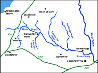
The River Ottery is a small river in northeast Cornwall, United Kingdom. The river is about twenty miles (32 km) long from its source southeast of Otterham to its confluence with the River Tamar at Nether Bridge, two miles (3.2 km) northeast of Launceston.

The De Lank River is a small river in north Cornwall, England. It is a tributary of the River Camel and is approximately nine miles (14.5 km) long from its source on Bodmin Moor to its confluence with the Camel two miles (3 km) south of St Breward.

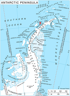
Rhesus Glacier is a 7 km long and 2.5 km wide glacier draining the east slopes of the Trojan Range on Anvers Island in the Palmer Archipelago, Antarctica southeast of Paris Peak. Situated east of Iliad Glacier, south of Lipen Glacier and north of Thamyris Glacier. Flowing northeastwards into Fournier Bay south of Thompson Peninsula and north of Predel Point.

The B52 road connects the A4 road in the village of Belcoo in County Fermanagh above the village green overlooking the shores of Lough MacNean. The road crosses the dismantled Sligo, Leitrim and Northern Counties Railway with the former station and closed level crossing. On leaving Belcoo the road heads westwards to Holywell with the shore of Lough MacNean on the left over the fields. The road continues to Garrison, County Fermanagh, connecting with the B53 and onwards to Drumlisaleen and connecting at Corry Cross Roads with the A46 road in Belleek, County Fermanagh on the border of County Donegal and County Fermanagh. Corry Cross Roads which is in Belleek is the most westerly numbered road junction in the UK.

KYOX, "the Ox", is a radio station airing a country music format licensed to Comanche, Texas, broadcasting on 94.3 MHz FM. The station is owned by Robert Elliott, Jr., through licensee Villecom LLC,
KTYR is a radio station licensed to Trinity, Texas. The station broadcasts a Spanish Religious format and is owned by Aleluya Broadcasting Network.

Arcadia is a village in the towns of Richmond and Exeter in the U.S. state of Rhode Island.
Columbia Center is a historic neighborhood of the city of Pataskala in Licking County, Ohio, United States. It lies slightly more than 1 mile (1.6 km) west of Pataskala's downtown.
Invergordon distillery is a Scotch whisky grain distillery at Invergordon in Easter Ross, in Ross and Cromarty, Highland, Scotland.
![]()
Coordinates: 50°31′35″N4°41′48″W / 50.52639°N 4.69667°W
| This Cornwall location article is a stub. You can help Wikipedia by expanding it. |