
Raleigh is the capital city of the state of North Carolina and the seat of Wake County in the United States. It is the second-most populous city in North Carolina, after Charlotte. Raleigh is the tenth-most populous city in the Southeast, the 41st-most populous city in the U.S., and the largest city of the Research Triangle metro area. Raleigh is known as the "City of Oaks" for its many oak trees, which line the streets in the heart of the city. The city covers a land area of 147.6 sq mi (382 km2). The U.S. Census Bureau counted the city's population as 467,665 in the 2020 census. It is one of the fastest-growing cities in the United States. The city of Raleigh is named after Sir Walter Raleigh, who established the now-lost Roanoke Colony in present-day Dare County.

Wake County is located in the U.S. state of North Carolina. In the 2020 census, its population was 1,129,410, making it North Carolina's most-populous county. From July 2005 to July 2006, Wake County was the 9th-fastest growing county in the United States, with Cary and Raleigh being the 8th- and 15th-fastest growing cities, respectively.

Orange County is a county located in the Piedmont region of the U.S. state of North Carolina. As of the 2020 census, the population was 148,696. Its county seat is Hillsborough.

Durham County is a county located in the U.S. state of North Carolina. As of the 2020 census, the population was 324,833, making it the sixth-most populous county in North Carolina. Its county seat is Durham, which is the only incorporated municipality predominantly in the county, though very small portions of cities and towns mostly in neighboring counties also extend into Durham County. The central and southern parts of Durham County are highly urban, consisting of the city as well as several unincorporated suburbs. Southeastern Durham County is dominated by the Research Triangle Park, most of which is in Durham County. The northern third of Durham County is rural in nature.

Chatham County is a county located in the Piedmont area of the U.S. state of North Carolina. As of the 2020 census, the population was 76,285. Its county seat is Pittsboro.

Apex is a town in Wake County, North Carolina, United States. At its southern border, Apex encompasses the community of Friendship. In 1994, the downtown area was designated a historic district, and the Apex train depot, built in 1867, is designated a Wake County landmark. The depot location marks the highest point on the old Chatham Railroad, hence the town's name. The town motto is "The Peak of Good Living".
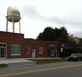
Garner is a town in Wake County, North Carolina, United States and a suburb of Raleigh. The population is 31,159 as of the 2020 census. The city limits are entirely within Wake County, though portions of unincorporated Wake County, as well as the Cleveland community in northern Johnston County, have Garner mailing addresses. It is part of the Research Triangle region of North Carolina and serves as a bedroom community for the region.

Durham is a city in the U.S. state of North Carolina and the county seat of Durham County. Small portions of the city limits extend into Orange County and Wake County. With a population of 283,506 in the 2020 census, Durham is the 4th-most populous city in North Carolina, and the 74th-most populous city in the United States. The city is located in the east-central part of the Piedmont region along the Eno River. Durham is the core of the four-county Durham-Chapel Hill, NC Metropolitan Statistical Area, which had a population of 649,903 at the 2020 census. The Office of Management and Budget also includes Durham as a part of the Raleigh-Durham-Cary, NC Combined Statistical Area, commonly known as the Research Triangle, which had a population of 2,043,867 at the 2020 census.

Morrisville is a town located primarily in Wake County, North Carolina, United States. The U.S. Census Bureau estimated the town's population to be 31,278 as of July 1, 2021. Morrisville is part of the Research Triangle metropolitan region. The regional name originated after the 1959 creation of the Research Triangle Park, located midway between the cities of Raleigh and Durham. The Research Triangle region encompasses the U.S. Census Bureau's Combined Statistical Area (CSA) of Raleigh-Durham-Cary. The estimated population of the Raleigh-Durham-Cary CSA was 2,144,608 as of 2021, with the Raleigh-Cary Metropolitan Statistical Area (MSA) portion estimated at 1,448,411 residents. The operational headquarters of Lenovo is located in the municipal limits.

The Research Triangle, or simply The Triangle, are both common nicknames for a metropolitan area in the Piedmont region of the U.S. state of North Carolina. Anchored by the cities of Raleigh, Durham and Chapel Hill, the region is home to three major research universities: North Carolina State University, Duke University, and the University of North Carolina at Chapel Hill, respectively. The "Triangle" name originated in the 1950s with the creation of Research Triangle Park located between the three anchor cities, which is the largest research park in the United States and home to numerous high tech companies.

The Research Triangle Regional Public Transportation Authority, known as GoTriangle, provides regional bus service to the Research Triangle region of North Carolina in Wake, Durham, and Orange counties. The GoTriangle name was adopted in 2015 as part of the consolidated GoTransit branding scheme for the Triangle. In 2022, the system had a ridership of 1,616,600, or about 5,300 per weekday as of the second quarter of 2023.

B. Everett Jordan Lake is a reservoir in New Hope Valley, west of Cary and south of Durham in Chatham County, North Carolina, in the United States; the northernmost end of the lake extends into southwestern Durham County.

Interstate 540 (I-540) and North Carolina Highway 540 (NC 540) are part of a partially completed beltway around the city of Raleigh in the US state of North Carolina, forming the Raleigh Outer Loop. When complete, the route will completely encircle the city, meeting its parent route of I-40 in two locations.

The 4th congressional district of North Carolina is located in the central region of the state. The district includes all of Alamance County, Durham County, Granville County, Orange County, and Person County, as well as a portion of Caswell County. With a Cook Partisan Voting Index rating of D+16, it is the most Democratic district in North Carolina.
WETC is an AM radio station, licensed to the cities of Wendell and Zebulon, North Carolina. It is owned by Divine Mercy Radio, Inc., a 501(c)(3) corporation. It is an all-volunteer, independently owned, non-commercial radio station that airs a Catholic radio format. The call letters now stand for We're EveryThing Catholic. The station's is known as Catholic 540-AM Divine Mercy Radio and is 100% listener supported. The station's signal targets the Research Triangle region of North Carolina, including the Raleigh radio market. In addition to Raleigh and Durham, other North Carolina cities and towns within the station's primary broadcast radius include Apex, Butner, Cary, Chapel Hill, Clayton, Fuquay-Varina, Garner, Goldsboro, Hillsborough, Holly Springs, Kinston, Knightdale, Morrisville, Rocky Mount, Smithfield, Wake Forest, Wendell, Wilson & Zebulon.

U.S. Highway 1 (US 1) is a north–south United States Numbered Highway which runs along the East Coast of the U.S. between Key West, Florida, and the Canada–United States border near Fort Kent, Maine. In North Carolina, US 1 runs for 174.1 miles (280.2 km) across the central region of the state. The highway enters North Carolina from South Carolina, southwest of Rockingham. US 1 runs northeast, passing through or closely bypassing Southern Pines and Sanford in the Sandhills region. It next passes through Cary, the state capital of Raleigh, and Wake Forest. The highway continues north to Henderson, before leaving the state at the Virginia state line, near Wise. The route is mostly a multilane divided arterial road, with several freeway segments. It serves as a strategic highway, connecting the North Carolina Sandhills and Research Triangle regions northward to the Southside region.
The Occoneechee Council (421) of the Boy Scouts of America serves some 8,200 youths and 4,600 adults in central North Carolina, US. The Occoneechee Council is the largest Boy Scout council in North Carolina and serves Chatham, Cumberland, Durham, Franklin, Granville, Harnett, Lee, Moore, Orange, Vance, Wake and Warren counties. These twelve counties are divided into four districts. Besides providing administrative support for Scout troops in their council area, they also maintain three large campgrounds.
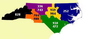
Area codes 919 and 984 are telephone area codes in the North American Numbering Plan (NANP) for all or parts of eleven counties in the east-central area of the U.S. state of North Carolina. They service the cities of Raleigh, Durham, Cary, and Chapel Hill/Carrboro, and the surrounding suburban areas of the Research Triangle metropolitan area, as well as the outlying towns and nearby rural areas of Oxford to the north, Sanford to the south, Goldsboro to the southeast, and Mebane to the west.
Durham–Orange Light Rail Transit (DOLRT) was a planned 17.7-mile (28.5 km) light rail line in central North Carolina. It was intended to start operating in 2028 between North Carolina Central University (NCCU) in eastern Durham and the UNC Medical Center in Orange County. This line was being developed by regional transit agency GoTriangle, and was in the engineering phase of the federal grant approval process when it was discontinued.

