Tropical Depression Greg

Last updated
Map key
  Tropical depression (≤38 mph, ≤62 km/h)
  Tropical storm (39–73 mph, 63–118 km/h)
  Category 1 (74–95 mph, 119–153 km/h)
  Category 2 (96–110 mph, 154–177 km/h)
  Category 3 (111–129 mph, 178–208 km/h)
  Category 4 (130–156 mph, 209–251 km/h)
  Category 5 (≥157 mph, ≥252 km/h)
  Unknown
Storm type
Disc Plain black.svg Tropical cyclone
Solid black.svg Subtropical cyclone
ArrowUp.svg Extratropical cyclone, remnant low, tropical disturbance, or monsoon depression

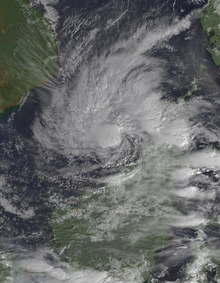
In the middle of December, two low-latitude monsoon troughs were located in the extreme western Pacific Ocean, well associated with a strong westerly wind burst that would spawn the system that would be Tropical Storm Fern and itself in the Northern Hemisphere. [1] The second trough which was located in the Southern Hemisphere, will also generate cloudiness in the Australian region that would also spawn three systems in the basin: namely Ophelia, Phil and Fergus. [1] A persistent area of convection was first mentioned by the JTWC on December 21 at 2100 UTC in their Significant Tropical Weather Advisory over the low latitudes of the South China Sea, well west of Brunei. [1] Two days later, the organization of the system became well-defined, as stated in their advisories on December 23 and in reports by weather stations in East Malaysia. [1] In addition, the system's convection improved within the next 24 hours due to the active wind burst. [1] At 04:00 UTC, the JTWC issued a Tropical Cyclone Formation Alert on the system, depicting a rapid convective organization being detected in the microwave and visible satellite images. [1] Upper-level divergence on the system also began to be seen in water-vapor imagery, also a sign of tropical cyclogenesis. [1] This was followed by the first warning by the agency on the system as Tropical Depression 43W, roughly two hours later. [1] Despite wind shear starting to impact the developing system, the depression intensified to a tropical storm on December 25 at 0000 UTC and was named Greg. [1] In post-tropical analysis, Greg may have likely intensified with gale-force winds, six hours later. [1] Combined effects of wind shear and the prevailing northeast monsoon made Greg slowly intensify while taking a southeastward track, before turning to the east, approaching northwestern Sabah, a state of Malaysia. [1] [2] The forward motion of Greg also increased, before reaching its peak intensity of 85 km/h (55 mph) and a minimum barometric pressure reading of 1002 hPa (29.59 inHg) that time. [1] It held this intensity until it made landfall along the town of Kudat between 1700 and 1800 UTC that day (03:00 and 04:00 am the next day, MYT) before hitting the major city of Sandakan, also that time. [1] These landfalls weakened Greg to a tropical depression as it entered Sulu Sea before passing through Tawi-Tawi on December 26. [1] It then entered the Celebes Sea on the afternoon of the same day before degenerating to a remnant low, shortly after as it encountered an unfavorable environment, namely colder sea surface temperatures. [1] At 0600 UTC on December 27, the JTWC issued their final warning on the system as it dissipated to the south of Mindanao, ending the very active 1996 Pacific typhoon season. [1] [2]

The Joint Typhoon Warning Center tracked and named the system; however, the Japan Meteorological Agency did not included Greg in their annual best track. [3]

Unusual formation

Tropical cyclones making landfall in Malaysia are extremely rare. [4] Only Greg and Vamei of 2001 had only significant effects in the country, since reliable records began. [1] [4]

The east-southeastward movement of Greg is also unusual. [1] Any tropical cyclone that forms and moves through the South China Sea will typically progress through the Indochina, became quasi-stationary, or move southwestward and dissipate immediately. [1] This is due to the well-established northeasterly wind flow from the Northern Hemisphere. [1] As Greg's predecessor formed in the waters near Vietnam, an unusually large wind pattern started to dominate the area where the system is and two low-level westerly winds existed from the north and south of the equator: namely the Northern and Southern Hemispheres. [1] [5] With these factors blocking the northeast monsoon to the east, the strong pattern of winds from the south helped Greg to take an eastward track. [1] [5] Adding on, the large circulation of developing Fern to its northeast were hypothesized as another reason for the system's east-southeastward motion as it started to dissipate. [1]

Preparations

Hours prior to Greg moving ashore, the Malaysian Meteorological Department (MetMalaysia) issued subsequent warnings of heavy rainfall and strong winds to the territory of Labuan and western Sabah, all in Malaysia. [6] Some fishermen were also advised to stay away from rough seas caused by the storm. [6] Over 5,600 individuals were evacuated due to the storm; however, some persons decided to stay in their houses. [7] [8]

Impact

Tropical Depression Greg
Greg 1996-12-25 0100Z.png
Greg at peak intensity near the island of Borneo on December 25
Statistics of affected areas by Greg [9]
PlaceAffected individualsAffected
residences
Reported deaths
Kota Kinabalu 8,7304,7174
Tuaran 8,1361,6975
Papar 772452
Penampang 32440
Keningau 5,040500227
Sipitang 13125
Tenom 3,50026
Telupid 7
Beaufort 12,867
Jumlah39,6877,280238

The effects of Greg in Sabah were catastrophic. Its state government sustained damages, worth RM 130 million ($31,574, 2021 USD). [10] Many buildings and infrastructures were either destroyed or sustained damages. [7] Trees and electricity poles were downed due to the strong winds, while many roads were flooded. [7] Over 25,000 individuals were left homeless, mainly due to landslides and floods that washed away their houses. [7] Billboards and debris were also scattered throughout the roadways. [11] Total deaths from Greg were counted to be 238, while 102 more persons were rendered missing. [7] [12] The impacts of Greg were separated by divisions, as follows:

West Coast Division

Kota Kinabalu

In the capital of Sabah, some residents reported that the roofs of hundreds of houses were torn and some trees were downed due to high winds. [13] Billboard scraps and garbages were also scattered and dispersed throughout the roads. [13] 8,730 individuals were required to be evacuated, while 4 deaths were recorded in the city. [9] 4,717 houses were either destroyed or washed out. [9] One of the floodlights of the Likas Stadium collapsed through a major road, making vehicles stranded. [14] In addition, the roof of the said stadium were blown away by the strong winds from Greg. [14]

The Sabah Foundation Building was required to close due to the serious damage to the area. [14] The rooms of the Chief Minister's Department sustained heavy damages to equipment as they were flooded. [14] The said damage was possibly caused by a shattered glass roof falling from an estimated distance of eight meters. [14] However, no injuries were reported on the building. [14]

Some primary and secondary schools are also affected by the floods. These are the SK Pulau Sepangar, SK Gentiasan, SK Kebagu Menggatal, SK Rampayan Menggatal, SK Tobobon Menggatal, SK Karambunai Telipok, SK Melawa Telipok, SK Lapasan Telipok, SMK Menggatal, SMK Pulau Gaya, SMK Inanam, SMK Agama Inanam, SMK Likas, and SMK Perempuan Likas. [15] Another newly built school, namely the Sekolah Kebangsaan Darau, sustained a roof damage. [15]

Tuaran District

In the district, 35 villages reported serious damages due to the floods. [15] In addition, the road that connects to the area and the state's capital were disrupted because of downed trees that blocked the thoroughfare. [15] The trees also cut the power supply through the populated district, affecting an unknown number of residents. [15] The clean water supply also became a problem due to the broken water pipes that connects the district from the main water supply, at the capital Kota Kinabalu. [15] Fifteen primary schools reported damages due to the storm, as well churches, resort houses, and major hotels. [15] [16] In the small town of Tamparuli, six schools reported damages; these are the SK Saradan, SK Pekan Tamparuli, SK Rungus, SK Lingga Baru, SK Guakon and SMK Pekan Tamparuli. [15]

At total of 8,136 individuals were affected, 1,697 houses were flooded and/or destroyed, and 5 people died in the district. [9]

Kampung Tanjung Aru

The weather station of the area was reported to be heavily damaged by Greg. [17] Some fishing boats were either destroyed or stranded while the others sunk through the rough seas caused by the storm. [17] No deaths were reported in the area. [9]

Inner Division

Aftermath

See also

Related Research Articles

<span class="mw-page-title-main">2006 Pacific typhoon season</span> Typhoon season in the Western Pacific Ocean

The 2006 Pacific typhoon season was an average season that produced a total of 23 named storms, 15 typhoons, and six super typhoons. The season ran throughout 2006, though most tropical cyclones typically develop between May and October. The season's first named storm, Chanchu, developed on May 9, while the season's last named storm, Trami, dissipated on December 20.

<span class="mw-page-title-main">2001 Pacific typhoon season</span> Typhoon season in the Western Pacific Ocean

The 2001 Pacific typhoon season was the fourth and final consecutive year with below-average activity, making it the lowest four-year period of activity since 1976–1979, due to the presence of a strong La Niña that had persisted from 1998 to 2001. However, it was more active than the previous seasons, producing twenty-five named storms, sixteen typhoons and three super typhoons, with a near normal Accumulated Cyclone Energy (ACE) of 307.3 units. It ran year-round in 2001, with most tropical cyclones in the northwestern Pacific Ocean tending between May and November.

<span class="mw-page-title-main">1998 Pacific typhoon season</span> Typhoon season in the Western Pacific Ocean

The 1998 Pacific typhoon season was at the time the least active Pacific typhoon season on record, until the record was surpassed 12 years later, spawning 16 tropical storms and 8 typhoons. The scope of this article is limited to the Pacific Ocean, north of the equator and west of the international date line. Storms that form east of the date line and north of the equator are called hurricanes; see 1998 Pacific hurricane season. Tropical Storms formed in the entire west Pacific basin were assigned a name by the Joint Typhoon Warning Center. Tropical depressions in this basin have the "W" suffix added to their number. Tropical depressions that enter or form in the Philippine area of responsibility are assigned a name by the Philippine Atmospheric, Geophysical and Astronomical Services Administration or PAGASA. This can often result in the same storm having two names.

<span class="mw-page-title-main">1996 Pacific typhoon season</span> Typhoon season in the Western Pacific Ocean

The 1996 Pacific typhoon season has no official bounds; it ran year-round in 1996, but most tropical cyclones tend to form in the northwestern Pacific Ocean between May and November. These dates conventionally delimit the period of each year when most tropical cyclones form in the northwestern Pacific Ocean.

<span class="mw-page-title-main">Tropical Storm Vamei</span> Pacific and North Indian tropical cyclone in 2001

Tropical Storm Vamei was a Pacific tropical cyclone that formed at about 85 nautical miles from the equator—closer than any other tropical cyclone on record. The last storm of the 2001 Pacific typhoon season, Vamei developed on 26 December at 1.4° N in the South China Sea. It strengthened quickly and made landfall along extreme southeastern Peninsular Malaysia. Vamei rapidly weakened into a remnant low over Sumatra on 28 December, and the remnants eventually re-organized in the North Indian Ocean. Afterward, the storm encountered strong wind shear once again, and dissipated on 1 January 2002.

<span class="mw-page-title-main">Typhoon Utor (2006)</span> Pacific typhoon in 2006

Typhoon Utor, known in the Philippines as Typhoon Seniang, swept through the central Philippines in December 2006, exacerbating the damage left behind by previous Philippine typhoon strikes that year. Residual moisture from the tropical cyclone indirectly contributed to extensive flooding in Malaysia. Utor originated from an area of disturbed weather that organized into a tropical depression on December 7 west-southwest of Yap. The cyclone steadily progressed westward while gradually intensifying, reaching tropical storm intensity late on December 7. On December 9 and the ensuing two days, Utor crossed the central Philippines and reached typhoon strength before weakening somewhat upon entry into the South China Sea. Reintensification ensued afterwards, and Utor reached its peak intensity on December 13 with maximum sustained winds of 155 km/h (100 mph) shortly after regaining typhoon strength. However, wind shear and dry air began to take its toll on Utor thereafter, quickly weakening the storm until its dissipation on December 15.

<span class="mw-page-title-main">Typhoon Pabuk (2007)</span> Pacific typhoon in 2007

Typhoon Pabuk, known in the Philippines as Tropical Storm Chedeng, was a minimal typhoon that formed on August 5, 2007. The system made landfall on Taiwan on August 7, and on August 9 Pabuk passed to the south of Hong Kong.

<span class="mw-page-title-main">2019 Pacific typhoon season</span> Typhoon season in the Western Pacific Ocean

The 2019 Pacific typhoon season was the costliest Pacific typhoon season on record, just ahead of the previous year. The season featured fairly above-average tropical cyclone activity for the second consecutive year, producing 29 named storms, 17 typhoons, and five super typhoons. The season's first named storm, Pabuk, reached tropical storm status on January 1, becoming the earliest-forming tropical storm of the western Pacific Ocean on record, breaking the previous record that was held by Typhoon Alice in 1979. The season's first typhoon, Wutip, reached typhoon status on February 20. Wutip further intensified into a super typhoon on February 23, becoming the strongest February typhoon on record, and the strongest tropical cyclone recorded in February in the Northern Hemisphere. The season's last named storm, Phanfone, dissipated on December 29 after it made landfall in the Philippines.

<span class="mw-page-title-main">Tropical Storm Brendan (1991)</span> Pacific severe tropical storm in 1991

Severe Tropical Storm Brendan, also known in the Philippines as Tropical Storm Helming, was a third consecutive tropical cyclone to strike China in July 1991. A weak surface circulation developed near Carolina Islands in July 15. Tracking west-northwestward, the circulation organized into a tropical depression in July 19. The tropical depression intensified into Tropical Storm Brendan in July 21 when the depression approached Philippines. Brendan quickly intensified to reach the first peak intensity of 115 km/h (70 mph) when it made landfall in Luzon, Philippines. After emerging in Luzon Strait as a strong tropical storm and continued to track west-northwestward, Brendan reached the secondary peak intensity of 105 km/h (65 mph) in July 23, before making landfall on Guangdong, China, 30 kilometres (19 mi) southwest of Macau in July 24. After making landfall, Brendan weakened and dissipated later that day.

<span class="mw-page-title-main">Typhoon Khanun (2005)</span> Pacific typhoon in 2005

Typhoon Khanun, known in the Philippines as Typhoon Kiko, was the strongest tropical cyclone to make landfall on Zhejiang Province since Wanda in 1956. Khanun developed from an area of convection east-southeast of Yap on September 5, thereafter tracking northwestward. The precursor reached tropical storm status on September 7 and typhoon intensity the next day. The tropical cyclone reached its peak intensity on September 10 with winds estimated at 155 km/h (100 mph) and a minimum barometric pressure of 945 mbar. After weakening slightly, Khanun moved ashore Zhejiang Province the next day, weakening further as it tracked over land. After recurving into the Yellow Sea on September 12, Khanun became extratropical; these remnants continued to track into the open North Pacific before they were last noted on September 16.

<span class="mw-page-title-main">2021 Pacific typhoon season</span> Typhoon season in the Western Pacific Ocean

The 2021 Pacific typhoon season was the second consecutive to have below-average tropical cyclone activity, with twenty-two named storms, and was the least active since 2011. Nine became typhoons, and five of those intensified into super typhoons. This low activity was caused by a strong La Niña that had persisted from the previous year. The season's first named storm, Dujuan, developed on February 16, while the last named storm, Rai, dissipated on December 21. The season's first typhoon, Surigae, reached typhoon status on April 16. It became the first super typhoon of the year on the next day, also becoming the strongest tropical cyclone in 2021. Surigae was also the most powerful tropical cyclone on record in the Northern Hemisphere for the month of April. Typhoons In-fa and Rai are responsible for more than half of the total damage this season, adding up to a combined total of $2.02 billion.

<span class="mw-page-title-main">2023 Pacific typhoon season</span> Typhoon season in the Western Pacific Ocean

The 2023 Pacific typhoon season is an ongoing event in the annual cycle of tropical cyclone formation, in which tropical cyclones form in the western Pacific Ocean. The season runs throughout 2023, though most tropical cyclones typically develop between May and October. The season's first named storm, Sanvu, developed on April 21. The following month, Mawar, intensified into the first typhoon of the season on May 21, becoming one of the strongest Northern Hemisphere tropical cyclones on record in May, and the second-strongest early-season tropical cyclone, behind only Surigae in April 2021. An exceptionally notable storm was Typhoon Doksuri in mid-late July, which devastated the northern Philippines, Taiwan and China, causing $15.4 billion in damage, as well as becoming the costliest typhoon to hit Mainland China.

<span class="mw-page-title-main">Tropical Storm Pabuk (2019)</span> Pacific tropical storm and North Indian cyclone in 2019

Tropical Storm Pabuk, also referred to as Cyclonic Storm Pabuk, was a weak storm that struck the Malay Peninsula in January 2019. It was also the earliest-forming storm in both the Northwestern Pacific Ocean and North Indian Ocean basins on record. Forming on the last day of 2018, Pabuk persisted into 2019, spanning two calendar years, and crossed into the North Indian Ocean basin several days later. The first tropical cyclone and named storm of the 2019 Pacific typhoon and North Indian Ocean cyclone seasons, Pabuk originated as a tropical disturbance in the South China Sea on December 28, 2018, which organized into a tropical depression on December 31. A day later, on January 1, 2019, the system intensified into a tropical storm and was named Pabuk. Pabuk made landfall in Thailand on January 4, emerging into the Bay of Bengal in the North Indian Ocean basin shortly afterward. Pabuk weakened after it entered the North Indian Ocean, eventually degenerating into a remnant low on January 7, before dissipating on the next day.

<span class="mw-page-title-main">Typhoon Georgia (1959)</span> Pacific typhoon in 1959

Typhoon Georgia was one of the more impactful typhoons that struck Japan, as well as one of the few observed tropical cyclones that made direct landfall in Russia as a tropical storm. A low pressure system formed in the vicinity of Guam on August 10 which formed Tropical Depression Fran, and a new low-level center formed from a fracture of a trough that split newly formed tropical depression in the midnight of August 12. The newly formed low level center was classified as a tropical storm and was named Georgia hours later by the Joint Typhoon Warning Center. The new tropical storm was tracked by Japan Meteorological Agency shortly afterwards and Georgia rapidly intensified into a typhoon. On the next day, Georgia further intensified after passing Chichi Jima and reached peak sustained winds of 110 knots (57 m/s) while quickly accelerating in the north-northwest direction before striking Chūbu region in Japan on evening of the same day as a weakening typhoon. After emerging on the Sea of Japan as a tropical storm on August 14, Georgia made landfall in Soviet Union as a tropical storm at the afternoon of the same day, before transforming into an extratropical storm quickly after landfall. Remnants of Georgia was last noted on Heilongjiang, China on August 16.

<span class="mw-page-title-main">Typhoon Saudel</span> Pacific typhoon in 2020

Typhoon Saudel, known in the Philippines as Typhoon Pepito, was a typhoon that affected the Philippines, Vietnam and Southern China in October 2020. It was seventeenth tropical storm and seventh typhoon of the 2020 Pacific typhoon season. The name Saudel was used for the first time, replacing Typhoon Soudelor in 2015, which caused serious damage in Taiwan and Mainland China. Saudel formed from a tropical disturbance east of the Philippines. The disturbance gradually organized and crossed the Philippines as a tropical storm. Once the system emerged into the South China Sea, it began to rapidly organize and intensify, becoming a typhoon early on October 22.

<span class="mw-page-title-main">Tropical Storm Krovanh (2020)</span> Pacific tropical storm in 2020

Tropical Storm Krovanh, known in the Philippines as Tropical Depression Vicky, was a tropical cyclone which caused deadly flooding in the Philippines during December 2020. The 31st depression and 23rd and final named storm of the 2020 Pacific typhoon season, Krovanh originated from a tropical depression which was first monitored by PAGASA, late on December 17. The system strengthened with PAGASA naming it Vicky, meanwhile the JMA monitored it as a low pressure area. The depression then made several landfalls over the Philippines on December 18–19 before moving out of the PAR on December 20, as it strengthened into a tropical storm according to the JMA and was named Krovanh. However, Krovanh was downgraded back to a tropical depression the next day, with the JTWC issuing their final advisory on December 22.

<span class="mw-page-title-main">Typhoon Flo (1993)</span> Pacific typhoon in 1993

Typhoon Flo, known in the Philippines as Typhoon Kadiang, was a catastrophic and deadly minimal typhoon that hit the northern Philippines during October 1993. It also caused the largest 72-hour forecast error for the year due to its interaction with the nearby Super Typhoon Ed. The twenty-seventh depression, twenty-second named storm and the eleventh typhoon of the 1993 Pacific typhoon season, Flo originated from an area of convection that was embedded from a monsoon trough during September 28. Two days later, a tropical depression formed within this trough, to the west of Guam. Slowly organizing, it remained a tropical depression until on October 2, when it strengthened to a tropical storm and was given the name Flo by the Japan Meteorological Agency. Slight wind shear from nearby Ed inhibited development; however, it intensified to a minimal typhoon as it neared the coastline of Luzon. On October 3, it made landfall near the Isabela-Aurora in its peak. It then crossed the country while weakening, and moved ashore near the South China Sea the next morning. It then unexpectedly moved back to the country due to its interaction with Ed, and it moved back to the Philippine Sea on October 17 before accelerating to the south of Japan. It then became extratropical on the next day.

<span class="mw-page-title-main">Typhoon Kyle (1993)</span> Western Pacific typhoon in 1993

Typhoon Kyle, known in the Philippines as Typhoon Luring, was the first of five deadly tropical cyclones that affected and impacted the Philippines and Vietnam during the 1993 Pacific typhoon season. The twenty-seventh named storm and thirteenth typhoon of the season, Kyle formed from a monsoon depression near Palau, associated with bursts of scattered convection. It then drifted west-northwest, strengthening to a tropical storm the next day. Land interaction prevented further intensification, and it crossed through the central Philippines while maintaining its intensity on November 20. Upon entering the South China Sea, the system strengthened to a severe tropical storm before rapidly intensifying to a typhoon, three days later. It soon reached its peak intensity that day, with one-minute maximum sustained winds of 175 km/h (110 mph), equivalent to a mid-level Category 2 typhoon. It held its strength until landfall in Vietnam later that evening. Weakening through the mountainous terrain of the country, it dissipated near the Cambodia–Thailand border on November 24.

<span class="mw-page-title-main">Tropical Storm Koguma</span> Pacific tropical storm in 2021

Tropical Storm Koguma was a weak tropical cyclone that made landfall in Vietnam, causing minor damage. The fourth named storm of the 2021 Pacific typhoon season, the system was first noted as an area of persistent convection on the South China Sea on June 10, with the JTWC assessing the system in its first advisory as a monsoon depression. Tracking west-northwestward, marginally conductive environmental conditions in the area allowed slight intensification while drifting towards Hainan Island. On the next day, the JMA upgraded the system to a tropical depression as it passed to the south of the territory before the agency upgraded the system to a tropical storm on June 12, being assigned the name Koguma. The JTWC; however still treated the system as a tropical depression until 12:00 UTC that day. It continued to move northwest over the warm waters of the Gulf of Tonkin, eventually making landfall in Vietnam over Thanh Hóa by the end of the same day, rapidly weakening afterward.

<span class="mw-page-title-main">Tropical cyclones in Malaysia</span>

Malaysia is a country in the southern part of Southeast Asia and is located to the south of the South China Sea. The sea separates two regions which consists of Peninsular Malaysia, located within the Malay Peninsula, and East Malaysia, located within the island of Borneo.

References

  1. 1 2 3 4 5 6 7 8 9 10 11 12 13 14 15 16 17 18 19 20 21 22 23 Kubat, Gary B.; Carle, William J.; Wells, Frank H.; Sanchez, Paul G.; Hong, Bryan Y.; Cross, Christopher; Boyd, Mathew A. (1996). 1996 Annual Tropical Cyclone Report (PDF) (Report). Joint Typhoon Warning Center. pp. 210–213. Retrieved April 20, 2021.
  2. 1 2 Knapp, Kenneth R.; Kruk, Michael C.; Levinson, David H.; Diamond, Howard J.; Neumann, Charles J. (2010). 1996 Tropical Storm GREG (1996356N08110). The International Best Track Archive for Climate Stewardship (IBTrACS): Unifying tropical cyclone best track data (Report). Bulletin of the American Meteorological Society. Retrieved April 20, 2021.
  3. Japan Meteorological Agency. "Japan Meteorological Agency | RSMC Tokyo - Typhoon Center | RSMC Best Track Data (Graphics) in 1996". www.jma.go.jp. Retrieved 2021-04-20.
  4. 1 2 Abdullah, Muhammad Helmi; Tussin, Abd Malik (2014). Tropical Cyclone, Rough Seas and Severe Weather Monitoring and Early Warning System In Malaysia (PDF). Malaysian Meteorological Department (MetMalaysia)'s Ministry of Science, Technology and Innovation (Report). Retrieved April 20, 2021.
  5. 1 2 Chang, Nursalleh K.; Kasim, Nursalleh Bin (2017). Impact of Tropical Cyclones Malaysia's Experience (PDF). Malaysian Meteorological Department (MMD) (Report). Retrieved April 21, 2021.
  6. 1 2 "Ribut Greg sepatutnya melanda Indo-China" (in Malay). Archived from the original on 2005-12-19. Retrieved April 21, 2021.
  7. 1 2 3 4 5 "Tropical Storm Greg leaves 163 people dead in Borneo". The Orlando Sentinel. 1996-12-30. p. 8. Retrieved 2021-04-21.
  8. Mohd Izham Unnip Abdullah (2017-12-17). "Nightmare of Tropical Storm Greg recalled, as houses swept away". New Straits Times (Malaysia). Retrieved April 21, 2021.
  9. 1 2 3 4 5 Megat Lutfi Megat Rahim (18 May 2008). "Trauma mangsa amukan ribut Greg di Sabah, Anak hanyut dalam gelap". Kosmo! Ahad. Retrieved 21 April 2021.
  10. "Malaysia Tropical Storm Situation Report No. 1 - Malaysia". ReliefWeb (UN DHA). 1996-12-31. Retrieved 2021-04-21.
  11. "Death toll from storm reaches 88". Dayton Daily News. 1996-12-27. p. 2. Retrieved 2021-04-21.
  12. "History of Typhoon and Cyclones in Malaysia". New Straits Times (Malaysia). Retrieved 2021-04-21.
  13. 1 2 "106 korban ribut Greg Lebih 100 lagi hilang dalam tragedi di Sabah". Utusan Malaysia Online (in Malay). Archived from the original on 2005-12-19. Retrieved April 22, 2021.
  14. 1 2 3 4 5 6 "Winds of Fury (Angry Greg) visited the land below the wind". Daily Express. December 27, 1996. Archived from the original on 2009-10-20. Retrieved April 22, 2021.
  15. 1 2 3 4 5 6 7 8 "39 sekolah alami kerosakan". Daily News Online (in Malay). December 31, 1996. Archived from the original on 2005-12-19. Retrieved April 22, 2021.
  16. "Gerakan mencari dipergiat". Daily News Online (in Malay). Archived from the original on 2005-12-19. Retrieved April 23, 2021.
  17. 1 2 "Ribut tropika landa Pantai Barat Sabah". Berita Harian Online (in Malay). Archived from the original on 2005-12-19. Retrieved April 23, 2021.