Tropical Depression Greg (1996)

Last updated
Tropical Storm Greg
Tropical storm (SSHWS)
Greg 1996-12-25 0100Z.png
Tropical Storm Greg at peak intensity near the island of Borneo on December 25
FormedDecember 24, 1996
DissipatedDecember 27, 1996
Highest winds 1-minute sustained: 85 km/h (50 mph)
Lowest pressure1002 hPa (mbar); 29.59 inHg
Fatalities238 total, 102 missing
Damage$280 million (1996 USD)
Areas affected Malaysia, Philippines, North Sulawesi
Part of the 1996 Pacific typhoon season

Tropical Storm Greg was a Pacific tropical cyclone that formed at an unusually low latitude in the South China Sea, and became the worst tropical cyclone to affect Malaysia since reliable records began. The last storm of the 1996 Pacific typhoon season, Greg formed on December 24 on the same two monsoon troughs that also spawned Tropical Storm Fern in the basin and cyclones Ophelia, Phil and Fergus in the Southern Hemisphere. The storm headed an east-southeastward track and despite an unfavorable environment for intensification, Greg strengthened to a tropical storm on Christmas Day. It then reached its peak intensity shortly, with maximum sustained winds of 85 km/h (50 mph) and a minimum barometric pressure of 1002 hPa before making landfall along the northern portion of the Malaysian state of Sabah between 1700 and 1800 UTC (3:00 - 4:00 am MYT) on December 26. After crossing the state, it weakened to a tropical depression before passing through Tawi-Tawi in the Philippines on the next day. Wind shear further degraded the system until it dissipated on December 27 on the Celebes Sea, south of Mindanao.

Contents

Greg was the only two systems to made landfall in Malaysia, before Vamei in 2001 did so, nearly five years later. The storm brought extensive and catastrophic damages across Sabah, causing over $280 million in damage (1996 USD) and 238 deaths, which mainly are foreigners and tourists. Another 102 individuals were also rendered missing. Flash floods and widespread mudslides were also recorded throughout the state, destroying houses and overflowing rivers, respectively.

Following the massive aftermath of the storm, the state government of Sabah immediately started to rehabilitate the areas that sustained damages, and relief operations were speeded. The government also allocated over $2 million for the operation process, while a relief fund collected $1 million for the affected evacuees. Mass graves were also started for the unidentifiable victims of the storm. Some authorities described Greg as one of the worst disasters in the history of Malaysia.

Meteorological history

Map plotting the storm's track and intensity, according to the Saffir-Simpson scale

Map key
Saffir-Simpson scale
.mw-parser-output .div-col{margin-top:0.3em;column-width:30em}.mw-parser-output .div-col-small{font-size:90%}.mw-parser-output .div-col-rules{column-rule:1px solid #aaa}.mw-parser-output .div-col dl,.mw-parser-output .div-col ol,.mw-parser-output .div-col ul{margin-top:0}.mw-parser-output .div-col li,.mw-parser-output .div-col dd{page-break-inside:avoid;break-inside:avoid-column}
.mw-parser-output .legend{page-break-inside:avoid;break-inside:avoid-column}.mw-parser-output .legend-color{display:inline-block;min-width:1.25em;height:1.25em;line-height:1.25;margin:1px 0;text-align:center;border:1px solid black;background-color:transparent;color:black}.mw-parser-output .legend-text{}
Tropical depression (<=38 mph, <=62 km/h)

Tropical storm (39-73 mph, 63-118 km/h)

Category 1 (74-95 mph, 119-153 km/h)

Category 2 (96-110 mph, 154-177 km/h)

Category 3 (111-129 mph, 178-208 km/h)

Category 4 (130-156 mph, 209-251 km/h)

Category 5 (>=157 mph, >=252 km/h)

Unknown
Storm type
Tropical cyclone
Subtropical cyclone
Extratropical cyclone / Remnant low / Tropical disturbance / Monsoon depression Greg 1996 track.png
Map plotting the storm's track and intensity, according to the Saffir–Simpson scale
Map key
  Tropical depression (≤38 mph, ≤62 km/h)
  Tropical storm (39–73 mph, 63–118 km/h)
  Category 1 (74–95 mph, 119–153 km/h)
  Category 2 (96–110 mph, 154–177 km/h)
  Category 3 (111–129 mph, 178–208 km/h)
  Category 4 (130–156 mph, 209–251 km/h)
  Category 5 (≥157 mph, ≥252 km/h)
  Unknown
Storm type
ArrowUp.svg Extratropical cyclone / Remnant low / Tropical disturbance / Monsoon depression

In the middle of December, two low-latitude monsoon troughs were located in the extreme western Pacific Ocean, well associated with a strong westerly wind burst that would spawn the system that would be Tropical Storm Fern and itself in the Northern Hemisphere. [1] The second trough which was located in the Southern Hemisphere, will also generate cloudiness in the Australian region that would also spawn three systems in the basin: namely Ophelia, Phil and Fergus. [1] A persistent area of convection was first mentioned by the JTWC on December 21 at 2100 UTC in their Significant Tropical Weather Advisory over the low latitudes of the South China Sea, well west of Brunei. [1] Two days later, the organization of the system became well-defined, as stated in their advisories on December 23 and in reports by weather stations in East Malaysia. [1] In addition, the system's convection improved within the next 24 hours due to the active wind burst. [1] At 04:00 UTC, the JTWC issued a Tropical Cyclone Formation Alert on the system, depicting a rapid convective organization being detected in the microwave and visible satellite images. [1] Upper-level divergence on the system also began to be seen in water-vapor imagery, also a sign of tropical cyclogenesis. [1] This was followed by the first warning by the agency on the system as Tropical Depression 43W, roughly two hours later. [1] Despite wind shear starting to impact the developing system, the depression intensified to a tropical storm on December 25 at 0000 UTC and was named Greg. [1] In post-tropical analysis, Greg may have likely intensified with gale-force winds, six hours later. [1] Combined effects of wind shear and the prevailing northeast monsoon made Greg slowly intensify while taking a southeastward track, before turning to the east, approaching northwestern Sabah, a state of Malaysia. [1] [2] The forward motion of Greg also increased, before reaching its peak intensity of 85 km/h (50 mph) and a minimum barometric pressure reading of 1002 hPa (29.59 inHg) that time. [1] It held this intensity until it made landfall along the town of Kudat between 1700 and 1800 UTC that day (03:00 and 04:00 am the next day, MYT) before hitting the major city of Sandakan, also that time. [1] These landfalls weakened Greg to a tropical depression as it entered Sulu Sea before passing through Tawi-Tawi on December 26. [1] It then entered the Celebes Sea on the afternoon of the same day before degenerating to a remnant low, shortly after as it encountered an unfavorable environment, namely colder sea surface temperatures. [1] At 0600 UTC on December 27, the JTWC issued their final warning on the system as it dissipated to the south of Mindanao, ending the very active 1996 Pacific typhoon season. [1] [2]

The Joint Typhoon Warning Center tracked and named the system; however, the Japan Meteorological Agency did not included Greg in their annual best track. [3]

Unusual formation

Tropical cyclones making landfall in Malaysia are extremely rare. [4] Only Greg and Vamei of 2001 had only significant effects in the country, since reliable records began. [1] [4]

The east-southeastward movement of Greg is also unusual. [1] Any tropical cyclone that forms and moves through the South China Sea will typically progress through the Indochina, became quasi-stationary, or move southwestward and dissipate immediately. [1] This is due to the well-established northeasterly wind flow from the Northern Hemisphere. [1] As Greg's predecessor formed in the waters near Vietnam, an unusually large wind pattern started to dominate the area where the system is and two low-level westerly winds existed from the north and south of the equator: namely the Northern and Southern Hemispheres. [1] [5] With these factors blocking the northeast monsoon to the east, the strong pattern of winds from the south helped Greg to take an eastward track. [1] [5] Adding on, the large circulation of developing Fern to its northeast were hypothesized as another reason for the system's east-southeastward motion as it started to dissipate. [1]

Preparations

Hours prior to Greg moving ashore, the Malaysian Meteorological Department (MetMalaysia) issued subsequent warnings of heavy rainfall and strong winds to the territory of Labuan and western Sabah, all in Malaysia. [6] Some fishermen were also advised to stay away from rough seas caused by the storm. [6] Over 5,600 individuals were evacuated due to the storm; however, some persons decided to stay in their houses. [7] [8]

Impact

Statistics of affected areas by Greg [9]
PlaceAffected individualsAffected
residences
Reported deaths
Kota Kinabalu 8,7304,7174
Tuaran 8,1361,6975
Papar 772452
Penampang 32440
Keningau 5,040500227
Sipitang 13125
Tenom 3,50026
Telupid 7
Beaufort 12,867
Jumlah39,6877,280238

The effects of Greg in Sabah were catastrophic. Its state government sustained damages, worth RM 130 million ($31,574, 2021 USD). [10] Many buildings and infrastructures were either destroyed or sustained damages. [7] Trees and electricity poles were downed due to the strong winds, while many roads were flooded. [7] Over 25,000 individuals were left homeless, mainly due to landslides and floods that washed away their houses. [7] Billboards and debris were also scattered throughout the roadways. [11] Total deaths from Greg were counted to be 238, while 102 more persons were rendered missing. [7] [12] The impacts of Greg were separated by divisions, as follows:

West Coast Division

Kota Kinabalu

In the capital of Sabah, some residents reported that the roofs of hundreds of houses were torn and some trees were downed due to high winds. [13] Billboard scraps and garbages were also scattered and dispersed throughout the roads. [13] 8,730 individuals were required to be evacuated, while 4 deaths were recorded in the city. [9] 4,717 houses were either destroyed or washed out. [9] One of the floodlights of the Likas Stadium collapsed through a major road, making vehicles stranded. [14] In addition, the roof of the said stadium were blown away by the strong winds from Greg. [14]

The Sabah Foundation Building was required to close due to the serious damage to the area. [14] The rooms of the Chief Minister's Department sustained heavy damages to equipment as they were flooded. [14] The said damage was possibly caused by a shattered glass roof falling from an estimated distance of eight meters. [14] However, no injuries were reported on the building. [14]

Some primary and secondary schools are also affected by the floods. These are the SK Pulau Sepangar, SK Gentiasan, SK Kebagu Menggatal, SK Rampayan Menggatal, SK Tobobon Menggatal, SK Karambunai Telipok, SK Melawa Telipok, SK Lapasan Telipok, SMK Menggatal, SMK Pulau Gaya, SMK Inanam, SMK Agama Inanam, SMK Likas, and SMK Perempuan Likas. [15] Another newly-built school, namely the Sekolah Kebangsaan Darau, sustained a roof damage. [15]

Tuaran District

In the district, 35 villages reported serious damages due to the floods. [15] In addition, the road that connects to the area and the state's capital were disrupted because of downed trees that blocked the thoroughfare. [15] The trees also cut the power supply through the populated district, affecting an unknown number of residents. [15] The clean water supply also became a problem due to the broken water pipes that connects the district from the main water supply, at the capital Kota Kinabalu. [15] Fifteen primary schools reported damages due to the storm, as well churches, resort houses, and major hotels. [15] [16] In the small town of Tamparuli, six schools reported damages; these are the SK Saradan, SK Pekan Tamparuli, SK Rungus, SK Lingga Baru, SK Guakon and SMK Pekan Tamparuli. [15]

At total of 8,136 individuals were affected, 1,697 houses were flooded and/or destroyed, and 5 people died in the district. [9]

Kampung Tanjung Aru

The weather station of the area was reported to be heavily damaged by Greg. [17] Some fishing boats were either destroyed or stranded while the others sunk through the rough seas caused by the storm. [17] No deaths were reported in the area. [9]

Inner Division

Aftermath

See also

Related Research Articles

2006 Pacific typhoon season

The 2006 Pacific typhoon season was a below-average season that produced a total of 23 named storms, 15 typhoons, and six super typhoons. The season ran throughout 2006, though most tropical cyclones typically develop between May and October. The season's first named storm, Chanchu, developed on May 9, while the season's last named storm, Trami, dissipated on December 20. Also, this season was more active, costly, and deadly than the previous season.

1996 Pacific typhoon season

The 1996 Pacific typhoon season has no official bounds; it ran year-round in 1996, but most tropical cyclones tend to form in the northwestern Pacific Ocean between May and November. These dates conventionally delimit the period of each year when most tropical cyclones form in the northwestern Pacific Ocean.

Tropical Storm Vamei Pacific and North Indian tropical cyclone in 2001

Tropical Storm Vamei was a Pacific tropical cyclone that formed closer to the equator than any other tropical cyclone on record. The last storm of the 2001 Pacific typhoon season, Vamei developed on 26 December at 1.4° N in the South China Sea. It strengthened quickly and made landfall along extreme southeastern Peninsular Malaysia. Vamei rapidly weakened into a remnant low over Sumatra on 28 December, and the remnants eventually re-organized in the North Indian Ocean. Afterward, the storm encountered strong wind shear once again, and dissipated on 1 January 2002.

Cyclone Graham Category 1 Australian region cyclone in 2003

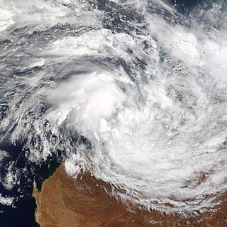
Cyclone Graham of the 2002–03 Australian region cyclone season was a weak tropical storm that affected Australia during late February and early March 2003. Graham originated from an area of convection that emerged onto water after sitting over Australia on 23 February. The interaction with a monsoon trough formed an area of low pressure that developed into Tropical Cyclone Graham on 27 February. The storm moved slowly to the east-southeast, and after turning to the south it peaked as a tropical storm and made landfall on Western Australia the next day. The cyclone weakened as it moved inland, and dissipated on 1 March. The storm dropped heavy rainfall and caused high winds, which produced flooding and downed trees. One fatality occurred, though no significant damages were reported.

1989–90 Australian region cyclone season

The 1989–90 Australian region cyclone season was an above average tropical cyclone season. It was also an event in the ongoing cycle of tropical cyclone formation. It ran from 1 November 1989 to 30 April 1990. The regional tropical cyclone operational plan also defines a tropical cyclone year separately from a tropical cyclone season, and the "tropical cyclone year" ran from 1 July 1989 to 30 June 1990.

1978–79 Australian region cyclone season

The 1978–79 Australian region cyclone season was the only season in which a reconnaissance aircraft flew into a tropical cyclone. Operationally, Australia's Bureau of Meteorology (BOM) tracked eleven tropical cyclones, while two additional systems were later added to the United States's Joint Typhoon Warning Center (JTWC) best track. Prior to 1985, the Australian region basin was defined as in the southern hemisphere between 80°E and 160°E, with the modern day season boundaries ranging from 1 November to 30 April of the following year. The first storm, an unnamed system, developed on 19 November 1978. The final cyclone, Kevin, dissipated by 12 May 1979. Tropical cyclones in this area were monitored by three Tropical Cyclone Warning Centres (TCWCs): the BOM in Perth, Darwin, and Brisbane.

Typhoon Joan (1959) Pacific typhoon in 1959

Typhoon Joan was an intense typhoon that caused minor damages in relative to the strength of the typhoon. Joan was the strongest typhoon of 1959 Pacific typhoon season, and one of the most intense Pacific typhoons on record. Joan formed from a surface center to the northeast of Guam on August 23, in which Japan Meteorological Agency began to track and classify the system as a tropical depression on the next day. A reconnaissance aircraft was sent to investigate the surface center and in 03:25 UTC on August 25 the surface center was classified as a tropical storm by Joint Typhoon Warning Center. The storm rapidly intensified into a typhoon in the same day it was formed. By the next three days as Joan tracks towards Taiwan, Joan explosively intensified to attain peak intensity with the pressure of 885 millibars (26.1 inHg), which is tied with Nina as the most intense Pacific typhoon on the record at the time. Shortly afterwards, Joan attained peak strength as a Category 5 equivalent typhoon on the Saffir–Simpson hurricane scale with winds of 165 knots (190 mph) before making landfall in Taiwan as a 160 knots (180 mph) typhoon, which was according to JTWC is the strongest landfall in the recorded history at the time. After making landfall, Joan weakened into a 110 knots (130 mph) typhoon before making landfall on Fujian, China as a Category 2 equivalent typhoon on the Saffir–Simpson hurricane scale with winds of 95 knots (109 mph). Once onshore, Joan did not degenerate quickly as Joan remained as a tropical cyclone for about one day before transitioning into a extratropical cyclone in 18:00 UTC of August 31. Extratropical remnants of Joan quickly traversed through South Korea and Japan before being last noted on 18:00 UTC, September 2.

2021 Pacific typhoon season Period of formation of tropical cyclones in the Western Pacific Ocean in 2021

The 2021 Pacific typhoon season is an ongoing event in the annual cycle of tropical cyclone formation, in which tropical cyclones form in the western Pacific Ocean. The season runs throughout 2021, with no seasonal boundaries, though most tropical cyclones typically develop between May and October. The season's first named storm, Dujuan, developed on February 16. The season's first typhoon, Surigae, reached typhoon status on April 16. It became the first super typhoon of the year on the next day, also becoming the strongest tropical cyclone in 2021. Surigae was also the most powerful tropical cyclone on record in the Northern Hemisphere for the month of April. Typhoons In-fa and Rai are responsible for more than half of the total damage this season, adding up to a combined total of $1.720 billion.

2021 North Indian Ocean cyclone season North Indian Ocean tropical cyclone season

The 2021 North Indian Ocean cyclone season is an ongoing event in the annual cycle of tropical cyclone formation. The North Indian Ocean cyclone season has no official bounds, but cyclones tend to form between April and December, peaking between May to November. These dates conventionally delimit the period of each year when most tropical cyclones form in the northern Indian Ocean.

Tropical Storm Pabuk (2019) Pacific tropical storm and North Indian cyclone in 2019

Tropical Storm Pabuk, also referred to as Cyclonic Storm Pabuk, was a weak storm that struck the Malay Peninsula in January 2019. It was also the earliest-forming storm in both the Northwestern Pacific Ocean and North Indian Ocean basins on record. Forming on the last day of 2018, Pabuk persisted into 2019, spanning two calendar years, and crossed into the North Indian Ocean basin several days later. The first tropical cyclone and named storm of the 2019 Pacific typhoon and North Indian Ocean cyclone seasons, Pabuk originated as a tropical disturbance in the South China Sea on December 28, 2018, which organized into a tropical depression on December 31. A day later, on January 1, 2019, the system intensified into a tropical storm and was named Pabuk. Pabuk made landfall in Thailand on January 4, emerging into the Bay of Bengal in the North Indian Ocean basin shortly afterward. Pabuk weakened after it entered the North Indian Ocean, eventually degenerating into a remnant low on January 7, before dissipating on the next day.

Tropical cyclones in 1993 Tropical cyclone year

During 1993, tropical cyclones formed within seven different bodies of water called basins. To date, 110 tropical cyclones formed, of which 78 were given names by various weather agencies. Only one Category 5 tropical cyclone was formed in 1993.

Typhoon Saudel Pacific typhoon in 2020

Typhoon Saudel, known in the Philippines as Typhoon Pepito, was a typhoon which affected the Philippines, Vietnam and Southern China in October 2020. The seventeenth tropical storm and seventh typhoon of the 2020 Pacific typhoon season, Saudel formed from a tropical disturbance east of the Philippines. The disturbance gradually organized and crossed the Philippines as a tropical storm. Once the system emerged into the South China Sea, it began to rapidly organize and intensify, becoming a typhoon early on October 22.

Tropical Storm Krovanh (2020) Pacific tropical storm in 2020

Tropical Storm Krovanh, known in the Philippines as Tropical Depression Vicky, was a tropical cyclone which caused deadly flooding in the Philippines during December 2020. The 31st depression and 23rd and final named storm of the 2020 Pacific typhoon season, Krovanh originated from a tropical depression which was first monitored by PAGASA, late on December 17. The system strengthened with PAGASA naming it Vicky, meanwhile the JMA monitored it as a low pressure area. The depression then made several landfalls over the Philippines on December 18–19 before moving out of the PAR on December 20, as it strengthened into a tropical storm according to the JMA and was named Krovanh. However, Krovanh was downgraded back to a tropical depression the next day, with the JTWC issuing their final advisory on December 22.

Tropical Storm Barijat

Tropical Storm Barijat, known in the Philippines as Tropical Storm Neneng, was a weak tropical storm that caused flooding in the far northern regions of the Philippines and Southern China. The thirty-third tropical depression and twenty-third tropical storm of the 2018 Pacific typhoon season, it was first noted as an area of convection in the South China Sea on September 6. On September 8, it was upgraded to a tropical depression, and by September 11, it intensified into a tropical storm, with the Japan Meteorological Agency (JMA) giving it the name Barijat. Barijat peaked in intensity 6 hours later, with 10-min winds of 40 knots and 1-min winds of 45 knots. Barijat continued westward, and on November 12 at 00:30 UTC, it made landfall over Zhanjiang, quickly dissipating afterwards.

Tropical Storm Dawn (1998) 1998 tropical cyclone

Tropical Storm Dawn was a weak tropical cyclone that caused 187 deaths in Vietnam, and was described as the worst storm to hit the region in 3 decades. The 27th tropical depression and 13th named storm of the 1998 Pacific typhoon season, Dawn formed from a monsoon trough in the South China Sea on November 16. The same day at 18:00 UTC, the Japan Meteorological Agency (JMA) assessed that it had become a tropical depression. The depression continued organizing, and on November 18 at 18:00 UTC, the Joint Typhoon Warning Center (JTWC) upgraded the depression to a tropical storm, giving it the name Dawn. Dawn peaked 1-minute sustained winds of 45 knots before making landfall near Cam Ranh, moving inland and quickly dissipating.

Typhoon Kyle (1993) Western Pacific typhoon in 1993

Typhoon Kyle, known in the Philippines as Typhoon Luring, was the first of five deadly tropical cyclones that affected and impacted the Philippines and Vietnam during the 1993 Pacific typhoon season. Being the twenty-seventh named storm and thirteenth typhoon of the season, Kyle formed from a monsoon depression near Palau, associated with bursts of scattered convection. It then drifted west-northwest, strengthening to a tropical storm the next day. Land interaction prevented further intensification, and it crossed through the central Philippines while maintaining its intensity on November 20. Upon entering the South China Sea, the system strengthened to a severe tropical storm before rapidly intensifying to a typhoon, three days later. It soon reached its peak intensity that day, with one-minute maximum sustained winds of 175 km/h (110 mph), equivalent to a mid-level Category 2 typhoon. It held its strength until landfall in Vietnam later that evening. Weakening through the mountainous terrain of the country, it dissipated near the Cambodia–Thailand border on November 24.

Typhoon Manny Western Pacific typhoon in 1993

Typhoon Manny, known in the Philippines as Typhoon Naning, was a deadly, long-lived, and unusual tropical cyclone that did a considerable loop before hitting the country during early-December 1993. It was also the second typhoon to hit the Visayas that year, following Kyle. Being the twenty-ninth named storm and fifteenth typhoon of the 1993 Pacific typhoon season, the system formed from a near-equatorial trough that also spawned Lola during the month in the east Caroline Islands on December 3. Moving northwestwards, it strengthened to a tropical storm on the next day before intensifying further to a severe tropical storm that night. The system attained typhoon status on December 8 as it underwent a clockwise loop, nearly the same as Pamela, 11 years later. It then rapidly intensified while moving to the southwest, with the typhoon reaching its peak of 220 km/h (140 mph) and an unusually high barometric pressure of 960 mbar before crossing the central Philippines on December 10 and 11. It soon moved through the South China Sea as a tropical storm before weakening to a tropical depression as it encountered high wind shear. However, it restrengthened back to a tropical storm as it moved back again to a favorable environment before passing to the south of Vietnam as the system weakened back below gale-force winds. It then dissipated on December 16 as it passed through Thailand.

Tropical Cyclone Audrey, also referred to by other media as Little Audrey, was a strong tropical cyclone that caused flooding and destruction on its path, from Queensland to New South Wales during early-to-mid January 1964. Audrey was first noted as a developing disturbance to the west of Moa Island in the Gulf of Carpentaria on January 7; however, the system formed a day prior. It moved east, passing to the north of Thursday Island before heading southeast, making a clockwise loop while making landfall in the Cape York Peninsula before strengthening to a Category 1 tropical cyclone, with the Bureau of Meteorology naming it Audrey. It moved south-southwestwards while slowly intensifying, becoming a Category 2 tropical cyclone before making landfall at Mornington Island on January 11. Land interaction degraded Audrey; however, it remained below severe tropical cyclone intensity until it made a second landfall on Gangalidda, Queensland on that day before weakening inland. However, the present-day brown ocean effect prevented Audrey from weakening as it progressed through the eastern Northern Territory before degrading to a Category 1 tropical cyclone as it turned southeastwards, drifting through southern Queensland before entering New South Wales on the afternoon of January 14 as it slowed down. Extratropical transition took place as Audrey restrengthened to a Category 2 tropical cyclone while drifting southeastwards, becoming fully extratropical as it emerged through the Coral Sea near Coffs Harbour on that day. It then brushed North Island of New Zealand as an extratropical storm before dissipating on January 16 in the Southern Pacific Ocean.

Tropical Storm Koguma Pacific tropical storm in 2021

Tropical Storm Koguma was a weak tropical cyclone that made landfall in Vietnam, causing minor damage. The fourth named storm of the 2021 Pacific typhoon season, the system was first noted as an area of persistent convection on the South China Sea on June 10, with the JTWC assessing the system in its first advisory as a monsoon depression. Tracking west-northwestwards, marginally conductive environmental conditions in the area allowed slight intensification while drifting towards Hainan Island. On the next day, the JMA upgraded the system to a tropical depression as it passed to the south of the territory before the agency upgraded the system to a tropical storm on June 12, being assigned the name Koguma. The JTWC; however still treated the system as a tropical depression until 12:00 UTC that day. It continued to move northwest over the warm waters of the Gulf of Tonkin, eventually making landfall in Vietnam over Thanh Hóa by the end of the same day, rapidly weakening afterward.

Tropical cyclones in Malaysia

Malaysia is a country in the southern part of Southeast Asia and is located to the south of the South China Sea. The sea separates two regions which consists of Peninsular Malaysia, located within the Malay Peninsula, and East Malaysia, located within the island of Borneo.

References

  1. 1 2 3 4 5 6 7 8 9 10 11 12 13 14 15 16 17 18 19 20 21 22 23 Kubat, Gary B.; Carle, William J.; Wells, Frank H.; Sanchez, Paul G.; Hong, Bryan Y.; Cross, Christopher; Boyd, Mathew A. (1996). 1996 Annual Tropical Cyclone Report (PDF) (Report). Joint Typhoon Warning Center. pp. 210–213. Retrieved April 20, 2021.
  2. 1 2 Knapp, Kenneth R.; Kruk, Michael C.; Levinson, David H.; Diamond, Howard J.; Neumann, Charles J. (2010). 1996 Tropical Storm GREG (1996356N08110). The International Best Track Archive for Climate Stewardship (IBTrACS): Unifying tropical cyclone best track data (Report). Bulletin of the American Meteorological Society. Retrieved April 20, 2021.
  3. Japan Meteorological Agency. "Japan Meteorological Agency | RSMC Tokyo - Typhoon Center | RSMC Best Track Data (Graphics) in 1996". www.jma.go.jp. Retrieved 2021-04-20.
  4. 1 2 Abdullah, Muhammad Helmi; Tussin, Abd Malik (2014). Tropical Cyclone, Rough Seas and Severe Weather Monitoring and Early Warning System In Malaysia (PDF). Malaysian Meteorological Department (MetMalaysia)'s Ministry of Science, Technology and Innovation (Report). Retrieved April 20, 2021.
  5. 1 2 Chang, Nursalleh K.; Kasim, Nursalleh Bin (2017). Impact of Tropical Cyclones Malaysia's Experience (PDF). Malaysian Meteorological Department (MMD) (Report). Retrieved April 21, 2021.
  6. 1 2 "Ribut Greg sepatutnya melanda Indo-China" (in Malay). Archived from the original on 2005-12-19. Retrieved April 21, 2021.
  7. 1 2 3 4 5 "Tropical Storm Greg leaves 163 people dead in Borneo". The Orlando Sentinel. 1996-12-30. p. 8. Retrieved 2021-04-21.
  8. Mohd Izham Unnip Abdullah (2017-12-17). "Nightmare of Tropical Storm Greg recalled, as houses swept away". New Straits Times (Malaysia). Retrieved April 21, 2021.
  9. 1 2 3 4 5 Megat Lutfi Megat Rahim (18 May 2008). "Trauma mangsa amukan ribut Greg di Sabah, Anak hanyut dalam gelap". Kosmo! Ahad. Retrieved 21 April 2021.
  10. "Malaysia Tropical Storm Situation Report No. 1 - Malaysia". ReliefWeb (UN DHA). 1996-12-31. Retrieved 2021-04-21.
  11. "Death toll from storm reaches 88". Dayton Daily News. 1996-12-27. p. 2. Retrieved 2021-04-21.
  12. "History of Typhoon and Cyclones in Malaysia". New Straits Times (Malaysia). Retrieved 2021-04-21.
  13. 1 2 "106 korban ribut Greg -- Lebih 100 lagi hilang dalam tragedi di Sabah". Utusan Malaysia Online (in Malay). Archived from the original on 2005-12-19. Retrieved April 22, 2021.
  14. 1 2 3 4 5 6 "Winds of Fury (Angry Greg) visited the land below the wind". Daily Express. December 27, 1996. Archived from the original on 2009-10-20. Retrieved April 22, 2021.
  15. 1 2 3 4 5 6 7 8 "39 sekolah alami kerosakan". Daily News Online (in Malay). December 31, 1996. Archived from the original on 2005-12-19. Retrieved April 22, 2021.
  16. "Gerakan mencari dipergiat". Daily News Online (in Malay). Archived from the original on 2005-12-19. Retrieved April 23, 2021.
  17. 1 2 "Ribut tropika landa Pantai Barat Sabah". Berita Harian Online (in Malay). Archived from the original on 2005-12-19. Retrieved April 23, 2021.