Truckee Tahoe Airport

Last updated
Truckee Tahoe Airport
Truckee Tahoe Airport (cropped).jpg
Main airport building in 2018
Summary
Airport typePublic
OwnerTruckee Tahoe Airport District
Serves Truckee, California
Elevation  AMSL 5,904 ft / 1,800 m
Coordinates 39°19′12″N120°08′22″W / 39.32000°N 120.13944°W / 39.32000; -120.13944
Website truckeetahoeairport.com
Runways
Direction LengthSurface
ftm
11/297,0012,134 Asphalt
2/204,6541,419Asphalt
Statistics (2017)
Aircraft operations35,000
Based aircraft114
Sources: airport website [1] and FAA [2]
A Beechcraft Baron landing on runway 19, 2012 (now runway 20) Landing at Truckee.JPG
A Beechcraft Baron landing on runway 19, 2012 (now runway 20)

Truckee Tahoe Airport [1] ( IATA : TKF, ICAO : KTRK, FAA LID : TRK) is a public airport two miles east of Truckee, California, United States. [2] The airport is in both Nevada County and Placer County. It is owned by Truckee Tahoe Airport District, [1] a bi-county special district. The FAA's National Plan of Integrated Airport Systems for 2009–2013 called it a general aviation airport. [3]

Contents

Many U.S. airports use the same three-letter location identifier for the FAA and IATA, but Truckee Tahoe Airport is TRK to the FAA and TKF to IATA. [4] (IATA lists TRK as Juwata Airport in Tarakan, North Kalimantan, Indonesia.) [5]

Facilities

Truckee-Tahoe Airport covers 2,280 acres (920  ha ) at an elevation of 5,904 ft (1,800 m). It has two asphalt runways: 11/29 is 7,001 by 100 ft (2,134 by 30 m) and 2/20 is 4,654 by 75 ft (1,419 by 23 m). [2]

A seasonal control tower opened June 1, 2017 and operated through September 15. The tower reopened in December of 2017 as a year round tower. The tower opens daily at 0700L. Closing times change depending on the season.

In 2016 the District reported 32,524 aircraft operations.

In the year ending December 31, 2017 the airport had 35,000 aircraft operations, average 95 per day: 97% general aviation, 3% air taxi, and less than 1% military. 114 aircraft were then based at this airport: 98 single-engine, 7 multi-engine, 1 jet, 3 helicopters, 4 glider and 1 ultralight. [2]

While the airport does not offer any commercial service, such service is available from Reno-Tahoe International Airport.

Runway elevation is 5,900 ft (1,800 m), pattern altitude is 7,000 ft (2,100 m). Both runways are lighted. Density altitude can exceed 9,000 ft (2,700 m) in summer months. Downdrafts can occur on final to RWY 20. Glider pilots use left traffic RWY 20. Powered aircraft use right traffic RWY 20.

100LL and Jet A are available 7am - 7pm, and self serve 100LL is available 7am - 9pm. There are 210 paved tie-downs for transient parking, no landing fees and low overnight tie-down fees.

The airport is attended seven days a week, 7am - 9pm. Snow removal equipment is operated round-the-clock as needed. Pre-heating services and aircraft maintenance are offered by local FBOs. No de-icing services are available.

The airport had a 500-gallon underground heating oil tank removed in 1986. Small amounts of oil that had leaked were monitored and removed; six remaining above-ground tanks were functioning satisfactorily and are regularly tested. [6]

Airlines and destinations

AirlinesDestinationsRefs
Southern Airways Express San Carlos [7]

Accidents and incidents

Climate

Climate data for Truckee-Tahoe Airport, California, 1991–2020 normals: 5900ft (1798m)
MonthJanFebMarAprMayJunJulAugSepOctNovDecYear
Record high °F (°C)65
(18)
71
(22)
74
(23)
79
(26)
88
(31)
94
(34)
99
(37)
98
(37)
96
(36)
86
(30)
75
(24)
63
(17)
99
(37)
Mean maximum °F (°C)56.7
(13.7)
60.4
(15.8)
65.4
(18.6)
73.3
(22.9)
79.3
(26.3)
90.0
(32.2)
94.0
(34.4)
93.5
(34.2)
89.7
(32.1)
79.7
(26.5)
70.7
(21.5)
56.5
(13.6)
95.0
(35.0)
Mean daily maximum °F (°C)42.4
(5.8)
43.9
(6.6)
48.9
(9.4)
55.6
(13.1)
64.8
(18.2)
75.5
(24.2)
84.8
(29.3)
83.9
(28.8)
77.5
(25.3)
64.8
(18.2)
51.7
(10.9)
41.3
(5.2)
61.3
(16.3)
Daily mean °F (°C)27.9
(−2.3)
29.0
(−1.7)
33.7
(0.9)
38.8
(3.8)
47.1
(8.4)
55.6
(13.1)
62.5
(16.9)
60.5
(15.8)
55.0
(12.8)
45.0
(7.2)
34.7
(1.5)
27.6
(−2.4)
43.1
(6.2)
Mean daily minimum °F (°C)13.4
(−10.3)
14.1
(−9.9)
18.6
(−7.4)
21.9
(−5.6)
29.4
(−1.4)
35.8
(2.1)
40.3
(4.6)
37.2
(2.9)
32.4
(0.2)
25.1
(−3.8)
17.8
(−7.9)
13.9
(−10.1)
25.0
(−3.9)
Mean minimum °F (°C)−2.9
(−19.4)
−1.1
(−18.4)
4.8
(−15.1)
11.2
(−11.6)
19.7
(−6.8)
24.8
(−4.0)
31.7
(−0.2)
30.1
(−1.1)
24.5
(−4.2)
14.3
(−9.8)
2.2
(−16.6)
−4.8
(−20.4)
−9.7
(−23.2)
Record low °F (°C)−22
(−30)
−12
(−24)
−8
(−22)
6
(−14)
14
(−10)
21
(−6)
23
(−5)
23
(−5)
18
(−8)
4
(−16)
−13
(−25)
−22
(−30)
−22
(−30)
Average precipitation inches (mm)4.94
(125)
4.82
(122)
4.19
(106)
1.85
(47)
1.80
(46)
0.73
(19)
0.47
(12)
0.47
(12)
0.56
(14)
1.66
(42)
2.52
(64)
5.14
(131)
29.15
(740)
Average snowfall inches (cm)20.6
(52)
24.8
(63)
25.5
(65)
5.9
(15)
1.7
(4.3)
0.0
(0.0)
0.0
(0.0)
0.0
(0.0)
0.2
(0.51)
1.9
(4.8)
12.9
(33)
15.7
(40)
109.2
(277.61)
Source 1: NOAA [14]
Source 2: XMACIS2 (snowfall, records & monthly max/mins) [15]

Related Research Articles

<span class="mw-page-title-main">Montrose Regional Airport</span> Airport in Montrose, Colorado

Montrose Regional Airport is a non-towered public airport on the northwest side of Montrose, in zip code 81401 in southwestern Colorado. Its two runways are at elevation 5,759 feet. MTJ covers 966 acres of land.

<span class="mw-page-title-main">Fort Lauderdale Executive Airport</span> Airport in Florida, United States

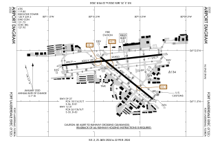
Fort Lauderdale Executive Airport is a general aviation airport located within the city limits of Fort Lauderdale, in Broward County, Florida, United States, five miles (8.0 km) north of downtown Fort Lauderdale. It is a division of the Transportation and Mobility Department of the City of Fort Lauderdale.

<span class="mw-page-title-main">Rimouski Aerodrome</span> Airport in Rimouski, Quebec

Rimouski Aerodrome is a registered aerodrome located 1.8 nautical miles northeast of Rimouski, Quebec, Canada. It only handles general aviation and cargo flights.

<span class="mw-page-title-main">Gillespie Field</span> Airport in El Cajon, California

Gillespie Field is a county-owned public towered airport 11.5 miles northeast of downtown San Diego, in El Cajon, San Diego County, California, United States.

<span class="mw-page-title-main">Danbury Municipal Airport</span> Airport in Connecticut, United States of America

Danbury Municipal Airport is a public use general aviation and commercial airport located three miles (5 km) southwest of the central business district of Danbury, in Fairfield County, Connecticut, United States. The airport opened in 1930. It is currently run by the City of Danbury under the management of Michael Safranek. It is included in the Federal Aviation Administration (FAA) National Plan of Integrated Airport Systems for 2017–2021, in which it is categorized as a regional reliever airport facility.

<span class="mw-page-title-main">Smyrna Airport (Tennessee)</span> Airport in Smyrna, TN, US

Smyrna Airport is a public general aviation and military use airport located two nautical miles (4 km) north of the central business district of Smyrna, a town in Rutherford County, Tennessee, United States. It is owned by the Smyrna / Rutherford County Airport Authority. Smyrna Airport is the third largest airport in Tennessee and is the state's busiest general aviation airport. Prior to March 1971, the facility was an active military installation known as Sewart Air Force Base.

<span class="mw-page-title-main">Yolo County Airport</span> Airport

Yolo County Airport is six miles northeast of Winters, five miles northwest of Davis and five miles southwest of Woodland, all in Yolo County, California. Magnetic variation is 16E.

<span class="mw-page-title-main">Sacramento Executive Airport</span> Airport in Sacramento, California

Sacramento Executive Airport is a public airport three miles (5 km) south of downtown Sacramento, in Sacramento County, California, United States. The airport covers 540 acres (219 ha) and has two lit runways and a helipad.

TRK or trk may refer to:

<span class="mw-page-title-main">Western Carolina Regional Airport</span> Airport

Western Carolina Regional Airport is a county-owned public-use airport located 2 miles (3.2 km) west of the central business district of Andrews, in Cherokee County, North Carolina, United States. It was formerly known as Andrews-Murphy Airport.

<span class="mw-page-title-main">Sussex Airport (New Jersey)</span> Airport

Sussex Airport is a mile southwest of Sussex in Wantage Township, Sussex County, New Jersey. It is just outside Sussex Borough. The public-use airport is privately owned by Sussex Aviation LLC which purchased it in 2015.

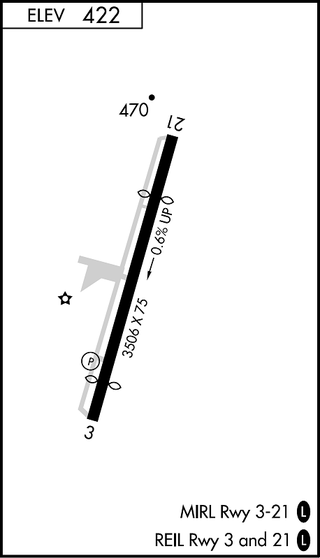
Santa Ynez Airport is a public airport located one mile (2 km) southeast of the central business district of Santa Ynez, in the Santa Ynez Valley of Santa Barbara County, California, United States. The airport covers 125 acres (51 ha) and has one runway (08/26), measuring 2,804 x 75 ft.. The airport does not have a control tower but does offer some services, including 24-hour access to both 100LL and Jet A self-service fuel and tie-downs for transient aircraft.

<span class="mw-page-title-main">Juwata International Airport</span> Airport in North Kalimantan, Indonesia

Juwata International Airport is an international airport in Tarakan, North Kalimantan, Indonesia. It is located on the island of Tarakan which is off the coast of Borneo. The airport was the main Allied objective during the Battle of Tarakan (1945). The airport is planned to be a transit hub for people from other countries such as Malaysia, Brunei and Philippines who is going to travel to other cities in Indonesia. Juwata Airport is a destination point of the ASEAN Single Aviation Market under Protocol I and II.

<span class="mw-page-title-main">Aurora State Airport</span> Airport in near Aurora, Oregon

Aurora State Airport is a public airport located one mile (2 km) northwest of the central business district of Aurora, a city in Marion County, Oregon, United States. It is owned by the Oregon Department of Aviation.

<span class="mw-page-title-main">Easton Airport (Maryland)</span> Airport

Easton Airport, also known as Easton/Newnam Field, is a county-owned, public-use airport located two nautical miles north of the central business district of Easton, a town in Talbot County, Maryland, United States.

<span class="mw-page-title-main">New Smyrna Beach Municipal Airport</span> Airport

New Smyrna Beach Municipal Airport, also known as Jack Bolt Field, is a public airport located three miles (5 km) northwest of the central business district of New Smyrna Beach, a city in Volusia County, Florida, United States. It is owned by the City of New Smyrna Beach.

<span class="mw-page-title-main">Indianapolis Metropolitan Airport</span> Airport in Fishers, IN, US

Indianapolis Metropolitan Airport is a public airport in Fishers, Hamilton County, Indiana, United States. It is 8 miles (13 km) northeast of downtown Indianapolis, is owned by the Indianapolis Airport Authority and is a reliever airport for Indianapolis International Airport.

<span class="mw-page-title-main">Conroe-North Houston Regional Airport</span> Airport in Texas, United States

Conroe-North Houston Regional Airport is a public-use airport in Conroe, Texas, United States, 37 miles (60 km) north of the central business district of Houston. It is publicly owned by Montgomery County.

Mesquite Metro Airport is a public use airport in Dallas County, Texas, 3 nautical miles (5.6 km) east of the central business district of Mesquite. The airport is west of the border of Dallas County and Kaufman County.

<span class="mw-page-title-main">Marianna Municipal Airport</span> Airport

Marianna Municipal Airport is an airport in Marianna, Jackson County, Florida, 5 miles (8.0 km) northeast of Downtown Marianna. The Federal Aviation Administration (FAA)'s National Plan of Integrated Airport Systems for 2009–2013 categorized it as a general aviation airport. It was formerly Graham Air Base.

References

  1. 1 2 3 Truckee Tahoe Airport, official site
  2. 1 2 3 4 FAA Airport Form 5010 for TRK PDF . Federal Aviation Administration. Effective 13 July 2023.
  3. National Plan of Integrated Airport Systems for 2009–2013: Appendix A: Part 1 (PDF, 1.33 MB). Federal Aviation Administration. Updated 15 October 2008.
  4. "Truckee, California - Truckee-Tahoe Airport (IATA: TKF, ICAO: KTRK, FAA: TRK)". Great Circle Mapper. Retrieved 24 May 2010.
  5. "Tarakan, Borneo, Indonesia - Juwata Airport (IATA: TRK, ICAO: WALR)". Great Circle Mapper. Retrieved 24 May 2010.
  6. Phase I Environmental Site Assessment, Truckee, California, Earth Metrics Inc., 1989
  7. "Routes". Southern Airways Express . February 2024. Retrieved April 18, 2024.
  8. "National Transportation Safety Board - Aviation Accident Final Report". National Transportation Safety Board. 25 July 2007. Retrieved 7 January 2023.
  9. ncs-import. "Crew killed in Truckee jet crash identified". www.nnbw.com. Retrieved 2023-01-07.
  10. "One dead, one injured in plane crash near Truckee". June 15, 2021.
  11. "4 confirmed dead after business jet crashes into wooded area in Truckee". July 26, 2021.
  12. "Truckee plane crash kills everyone aboard". The Mercury News. July 27, 2021.
  13. Maglunog, Tristan. "2 dead in single-engine plane crash in Truckee, California". ABC News. Retrieved 2024-04-01.
  14. "Truckee-Tahoe Airport, California 1991-2020 Monthly Normals" . Retrieved November 15, 2023.
  15. "xmACIS". National Oceanic and Atmospheric Administration. Retrieved November 15, 2023.