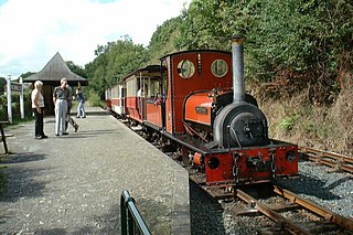
The Launceston Steam Railway is a 1 ft 11 1⁄2 in narrow gauge railway, in Cornwall, England. The railway operates from the town of Launceston to Newmills, where there is a farm park; it is 2 1⁄2 miles (4.0 km) long. The railway is built on the trackbed of the former standard gauge North Cornwall Railway.

North Cornwall is a constituency represented in the House of Commons of the UK Parliament by Scott Mann, a Conservative since the 2015 general election. Like all British constituencies, the seat elects one Member of Parliament (MP) by the first past the post system of election at least every five years. The seat was created in 1918. Since 1950, the constituency has been held by MPs from either the Conservative Party or the Liberal Democrats.
St Clether is a civil parish and village in Cornwall, England, United Kingdom. The village is situated on the east flank of Bodmin Moor approximately eight miles (13 km) west of Launceston in the valley of the River Inny. The population of the civil parish at the 2011 census was 156.

St Juliot is a civil parish in north-east Cornwall, England, United Kingdom. The parish is entirely rural and the only settlements are the hamlets of Beeny and Tresparrett. The parish population at the 2011 census was 328.

East Wivelshire and West Wivelshire are two of the ancient Hundreds of Cornwall.
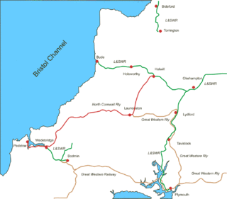
The North Cornwall Railway was a railway line running from Halwill in Devon to Padstow in Cornwall via Launceston, Camelford and Wadebridge, a distance of 49 miles 67 chains (80.21 km). Opened in the last decade of the nineteenth century, it was part of a drive by the London and South Western Railway (LSWR) to develop holiday traffic to Cornwall. The LSWR had opened a line connecting Exeter with Holsworthy in 1879, and by encouraging the North Cornwall Railway it planned to create railway access to previously inaccessible parts of the northern coastal area.

Werrington is a civil parish and former manor now in Cornwall, England, United Kingdom. Prior to boundary changes it straddled the Tamar and lay within the county of Devon. The portion on the west side was transferred to Cornwall in 1966. It is situated 1 mile (1.6 km) to the west of the Tamar, the traditional boundary between Devon and Cornwall, and 1 mile (1.6 km) north of Launceston.

St Stephens by Launceston Rural is a civil parish in the east of Cornwall, England, United Kingdom. It is in the Registration district of Launceston. The population of the parish in the 2001 census was 312, increasing to 360 and including Dutson at the 2011 census. The former parish of St Stephens by Launceston was abolished in 1894: St Stephens by Launceston Urban became part of the town of Launceston, while St Stephens by Launceston Rural became part of Launceston Rural District.
Dobwalls and Trewidland is a civil parish in south-east Cornwall, England, United Kingdom.

St Martin-by-Looe is a coastal civil parish in south Cornwall, England, United Kingdom. The parish is immediately east of the town and parish of Looe, seven miles (11 km) south of Liskeard. The parish is in the Liskeard Registration District and the population in the 2001 census was 321, which had increased to 429 at the 2011 census.
Launceston Priory was a priory at Newport, Launceston, Cornwall, England, UK.

Lammana Priory was a priory on Looe Island in Cornwall, UK, consisting of two Benedictine monks until 1289. It was owned by Glastonbury Abbey and the property was sold in 1289 to a local landowner.

Launceston is a town, ancient borough, and civil parish in Cornwall, England, United Kingdom. It is 1 mile (1.6 km) west of the middle stage of the River Tamar, which constitutes almost the entire border between Cornwall and Devon. The landscape of the town is generally steep particularly at a sharp south-western knoll topped by Launceston Castle. These gradients fall down to the River Kensey and smaller tributaries.

Dutson is a hamlet northeast of Launceston in Cornwall, England, and on the A388 main road. It is in the civil parish of St Stephens by Launceston Rural

Langore is a village in Cornwall, England. It is in the parish of St Stephens by Launceston Rural and is about halfway between St Stephens and Egloskerry.
Launceston Rural District was a local government division of Cornwall between 1894 and 1974. Established under the Local Government Act 1894, the rural district was enlarged in 1966 by the abolition of Broadwoodwidger Rural District, in Devon, to include the civil parishes of North Petherwin and Werrington.
Liddaton Halt was a railway station opened in 1938 by the Great Western Railway to serve the hamlet of Liddaton that lies between Coryton and Lydford in West Devon, England.
Tower Hill railway station was a railway station that served a rural district being named after a local farm, near the River Carey, Devon, England. It was located on the North Cornwall Railway 5 miles (8.0 km) southwest of Halwill

St Giles on the Heath, sometimes hyphenated as St Giles-on-the-Heath, is a village and civil parish in the far west of Devon, England. It forms part of the local government district of Torridge. The village is in the east of the parish and lies on the A388 road about eight miles south of the town of Holsworthy.

The River Kensey is a river in east Cornwall, England, UK which is a tributary of the River Tamar.
