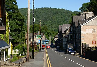
Betws-y-Coed is a village and community in the Conwy valley in Conwy County Borough, Wales, located in the historic county of Caernarfonshire, right on the boundary with Denbighshire, in the Gwydir Forest. It is now a very popular visitor destination in the Snowdonia National Park. The population of the community as of the 2021 census was 476, a decline on the previous census.

Llanrwst is a market town and community on the A470 road and the River Conwy, in Conwy County Borough, Wales, and the historic county of Denbighshire. It developed round the wool trade and became known also for the making of harps and clocks. Today, less than one mile from the edge of Snowdonia, its main pursuit is tourism. Notable buildings include almshouses, two 17th-century chapels, and the Parish Church of St Grwst, which holds a stone coffin of Llywelyn the Great. The 2011 census gave it a population of 3,323.

Trefriw is a village and community in Conwy County Borough, Wales. It lies on the river Crafnant a few miles south of the site of the Roman fort of Canovium, sited at Caerhun. At the last three censuses, the population of the community has been recorded as 842 in 1999, 915 in 2001, and 783 in 2011.

The River Conwy is a river in north Wales. From its source to its discharge in Conwy Bay it is 55 kilometres (34 mi) long and drains an area of 678 square km. "Conwy" was formerly anglicised as "Conway."
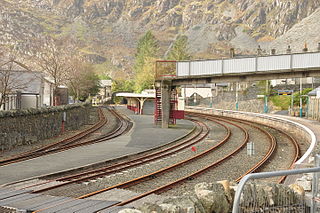
The Conwy Valley line is a railway line in north-west Wales. It runs from Llandudno via Llandudno Junction to Blaenau Ffestiniog, and was originally part of the London and North Western Railway, being opened in stages to 1879. The primary purpose of the line was to carry slate from the Ffestiniog quarries to a specially built quay at Deganwy for export by sea. The line also provided goods facilities for the market town of Llanrwst, and via the extensive facilities at Betws-y-Coed on the London to Holyhead A5 turnpike road it served many isolated communities in Snowdonia and also the developing tourist industry. Although only a little over 27 miles (43 km) between Llandudno and Blaenau Ffestiniog, the journey takes over one hour, largely due to the sinuous and steeply graded nature of the route taken. Most of the stations along the line are treated as request stops.

Llanbedr-y-Cennin is a small village in Conwy county borough, Wales, in the community of Caerhun.
Pont Fawr (also known as Llanrwst Bridge) crosses the River Conwy in the town of Llanrwst, Conwy County Borough, Wales. Traditionally attributed to the architect Inigo Jones, it was built in around 1636. The bridge is 51 m (167 ft) in length and carries vehicles and pedestrians. It is a Grade I listed building and a Scheduled monument.

Dolwyddelan railway station is a passenger station in the Lledr Valley, Wales, on the Conwy Valley Line from Llandudno Junction to Blaenau Ffestiniog, which is operated by Transport for Wales Rail. It is located at Pentre-Bont across the river a few hundred yards from the centre of Dolwyddelan. The station is unmanned.

North Llanrwst railway station is the only train passing station on the Conwy Valley line between Llandudno Junction and Blaenau Ffestiniog in Wales. The station has had several previous names, including Llanrwst and Trefriw, Llanrwst and Llanrwst North. This station is also a request stop.

Gwydir Castle is situated in the Conwy valley, Wales, a mile to the west of the ancient market town of Llanrwst and 1.5 miles (2.4 km) to the south of the large village of Trefriw. An example of a fortified manor house dating back to c. 1500, it is located on the edge of the floodplain of the river Conwy, and overlooked from the west by the now-forested slopes of Gwydir Forest.

Llanrhychwyn is a hamlet in Conwy county borough, Wales. It lies in the Conwy valley, less than a mile south of Trefriw, and a mile north-west of Llanrwst. Today neighbouring Trefriw is a village with a population of around 600, but in the time of Llywelyn Fawr, and up to the early 19th century, Llanrhychwyn was larger than Trefriw, which consisted simply of "a few houses here and there". Indeed, even today both Trefriw and Llanrhychwyn lie within the parish of Llanrhychwyn. The area around Llanrhychwyn had a population of only 178 in 2011.

Dolgarrog is a village and community in Conwy County Borough, in Wales, situated between Llanrwst and Conwy, very close to the Conwy River. The village is well known for its industrial history since the 18th century and the Eigiau dam disaster, which occurred in 1925. The population was 414 at the 2001 Census, increasing to 446 at the 2011 Census. The community extends up to, and includes part of, Llyn Cowlyd in the Carneddau.

Ysbyty Ifan is a small, historic village and community in the Conwy County Borough of Wales. The population in 2011 was 196 in 76 households, over 79% of the population were able to speak Welsh. It has one of the smallest populations of any Welsh community, the smallest being Ganllwyd. It is in the electoral ward of Uwch Conwy.

Ysgol Dyffryn Conwy is a bilingual co-educational comprehensive school in the town of Llanrwst in Conwy County Borough, North Wales. The school serves the community of Llanrwst and the many surrounding villages including the rural districts of Betws-y-Coed, Dolgarrog and Cerrigydrudion. There are around 658 pupils on roll, including 137 in the sixth form, which is lower than the figures at the time of the last inspection in 2014. Most of them are bilingual. The school has recently been moved onto one expanded site which had originally housed years 7-9 only. The site of the upper school has been developed into an NHS centre.

Tal-y-Bont is a small village in Conwy County Borough, Wales and lies in the Conwy Valley, west of the River Conwy, on the B5106 road, 6 mi (9.7 km) from the town of Conwy to the north, and six miles from Llanrwst to the south, and in the community of Caerhun. It lies adjacent to the village of Dolgarrog to the south, and below the small settlement of Llanbedr-y-Cennin to the west. The population is around 400.

Llanfair Talhaiarn, abbreviated to Llanfair TH, is a village and community approximately 5 miles (8.0 km) south of Abergele in Conwy county borough, Wales. Until 1974 it was included in Denbighshire. The population was 979 in 2001, increasing to 1,070 at the 2011 census with 44% being Welsh language speakers.

Llannefydd is a village and community in Conwy County Borough, in Wales. It is located on the border with Denbighshire, between the Afon Aled and River Elwy, 5.7 miles (9.2 km) north west of Denbigh, 5.8 miles (9.3 km) south west of St Asaph, 6.9 miles (11.1 km) south of Abergele and 15.2 miles (24.5 km) south east of Conwy. In the 2011 census the community parish had a population of 590. The community includes the village of Cefn Berain and part of the hamlet of Bont Newydd.
Bro Garmon is a sparsely populated community in Conwy County Borough, in Wales. It is located on the eastern side of the Conwy Valley, stretching from north east of Llanrwst to just west of Pentrefoelas, and includes the villages of Capel Garmon, Glan Conwy, Melin-y-Coed, Nebo, Oaklands, Rhydlanfair and Pentre-tafarn-y-fedw. Moel Seisiog, on the eastern boundary, rises to a height of 1,535 feet (468 m). The main settlement, Capel Garmon, lies 2.4 miles (3.9 km) east of Betws-y-Coed, 5.2 miles (8.4 km) north west of Pentrefoelas, 4.4 miles (7.1 km) south of Llanrwst and 15.7 miles (25.3 km) south of Conwy. At the 2001 census the community had a population of 648, increasing slightly at the 2011 census to 652.

Llanddoged and Maenan is a community in Conwy County Borough, in Wales. It is located in the Conwy Valley, on the eastern bank of the River Conwy, 2.3 miles (3.7 km) north east of Llanrwst, 15.7 miles (25.3 km) south west of Abergele and 13.3 miles (21.4 km) south of Conwy. The community includes the village of Llanddoged and the rural settlements around Maenan. At the 2001 census it had a population of 574, increasing to 602 at the 2011 census.

Melin-y-Coed is a small rural village in the county of Conwy, Wales.. The earliest surviving building in the village is Cyffdy Hall, built in 1596.