Contents
- Meteorological history
- Preparations
- Okinawa
- South Korea
- Impact
- Japan
- South Korea 2
- Aftermath
- See also
- References
- External links
Meteorological history

Tropical storm (39–73 mph, 63–118 km/h)
Category 1 (74–95 mph, 119–153 km/h)
Category 2 (96–110 mph, 154–177 km/h)
Category 3 (111–129 mph, 178–208 km/h)
Category 4 (130–156 mph, 209–251 km/h)
Category 5 (≥157 mph, ≥252 km/h)
Unknown
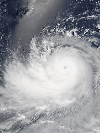
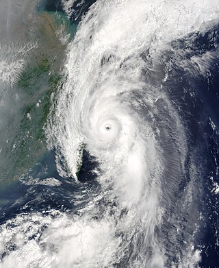
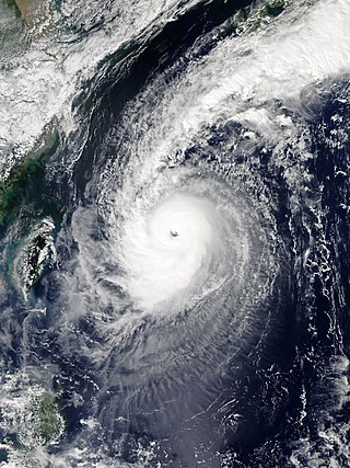
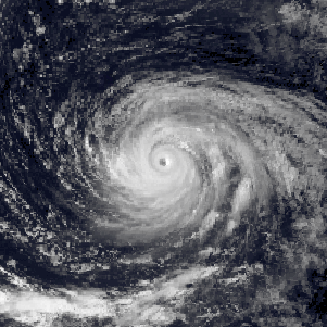
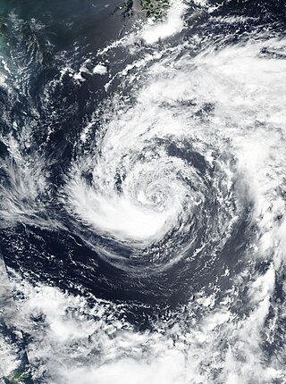
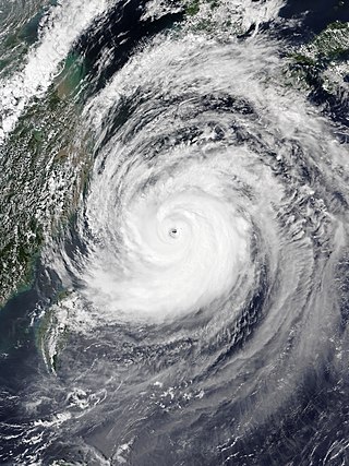
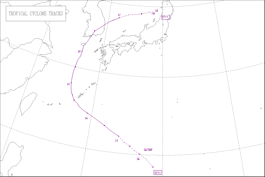
An area of disturbed weather developed northwest of Guam on September 10 and moved northwestward, slowly increasing in organisation. The Japan Meteorological Agency began monitoring the system as a tropical depression the next day. The depression continued to organise and strengthen, and the Joint Typhoon Warning Center issued a Tropical Cyclone Formation Alert on it during the afternoon of September 12, and began issuing advisories on Tropical Depression 12W an hour later. The JMA followed suit early on September 13 and initiated advisories on the system; PAGASA named the system Falcon shortly after. The depression continued to intensify, and the JMA upgraded it to Tropical Storm Nari later that morning. The storm then underwent rapid intensification that afternoon and evening, strengthening from a tropical depression to a typhoon in just 18 hours. The JMA upgraded Nari to a severe tropical storm late that afternoon, and by late that evening, Nari was upgraded to a typhoon. Nari reached its peak on September 14, and began weakening soon afterwards. It turned extratropical right after landfall in South Korea at tropical storm strength. [1]
Preparations
Okinawa

On September 14, Japan Airlines cancelled 14 flights in and out of Okinawa, affecting an estimated 5,300 people. [2] All Nippon Airways cancelled 54 flights, Ryukyu Air Commuter cancelled 24, Skymark cancelled two, and Japan Airlines cancelled an additional 16 flights the next day. An estimated 21,000 passengers cancelled their flights arrangements due to Nari. [3] United States Marine bases located in Okinawa were placed under Tropical Cyclone Condition of Readiness-3 as Nari approached the islands on September 15. Aircraft and important equipment were secured to prevent damage to them. [4] Several of the more important aircraft were transported to other locations throughout the Pacific. [5] Working parties were scrambled to quickly assess and repair damage following the typhoon. About 30 marine soldiers were placed on "Typhoon Watch". They were to ride out the storm at the Foster headquarters building until Tropical Cyclone Condition of Readiness-1 had been sounded. At that time, they were to survey the area for signs of damage. [4]
South Korea
At least 300 flights in and out of South Korea were cancelled due to Typhoon Nari. [6] About 130 of the cancelled flights were from Jeju Island. An additional 3,000 ferries were also cancelled from the island. [7] Several ports along the southern coast of South Korea were shut down due to the storm. [8] Typhoon warnings were issued for most of the southern regions of the country. [7]
Impact
Japan

Winds were recorded up to 101 km/h (63 mph) in the United States Marine base. [4] Damage at the base was primarily limited to trees. [9] The storm passed directly over Kumejima Island, [10] producing a record 226 km/h (140 mph) wind gust on the island. [11] A pressure of 948.4 hPa (mbar) was recorded as the eye passed over. [10] This record was eclipsed less than two weeks later by Typhoon Wipha which produced a wind gust of 252 km/h (157 mph). Total precipitation in Okinawa was estimated to have reached 120 mm (4.7 in), with rainfall rates peaking at 45.5 mm (1.79 in) per hour. [11] At least 4,500 residences were left without power throughout all the islands, most of which were on Kumejima. In Naha City, a wall collapsed due to the rain but caused no injuries. Cars were reportedly flipped over in Kumejima Town where the worst damage was dealt. Numerous buildings lost their windows and numerous trees were knocked down. [3] The outer bands of Nari trigged flooding which killed three people and injured three others in Kyushu. Fourteen homes were destroyed, 22 were damaged, and 117 others were affected. A total of 1,247 hectares of farmland was either damaged or destroyed by the typhoon. At the height of the storm, 4,800 households were without power and 3,700 were without water. Damages from both prefectures amounted to ¥31.4 billion ($323 million USD). [12]
South Korea
Throughout the country, a total of 479 structures were damaged or destroyed, displacing 948 people. The torrential rains submerged large areas of farmland and flooded roadways. [13] The hardest hit area was Jeju Island, where rainfall amounted to a record 590 mm (23 in). [10] At least 12 people were killed on the island and damages amounted to ₩28 billion ($19.2 million USD). [14] In all, 20 people were killed and damages amounted to ₩65.2 billion (US$70 million). [15]
Aftermath
Following Typhoon Nari, Jeju Island was declared a national disaster area by the South Korean government. Residents who lost 30 percent or more of their property were entitled to a nine-month extension to their tax deadlines. The government reported that they would cover about 90 percent of the costs for rehabilitation on the island. [14]
See also
Related Research Articles

The 2007 Pacific typhoon season was a near average season which featured 24 named storms, fourteen typhoons, and five super typhoons. It was an event in the annual cycle of tropical cyclone formation, in which tropical cyclones form in the western Pacific Ocean. The season ran throughout 2007, though most tropical cyclones typically develop between May and November. The season's first named storm, Kong-rey, developed on March 30, while the season's last named storm, Mitag, dissipated on November 27. The season's first typhoon, Yutu, reached typhoon status on May 18, and became the first super typhoon of the year on the next day.
Typhoon Ewiniar, known in the Philippines as Typhoon Ester, was the third named storm of the 2006 Pacific typhoon season and one that lasted for twelve days as a tropical cyclone, moving on a generally northward track. During its lifespan, it affected Palau, Yap, eastern China, the Ryūkyū Islands of Japan, South Korea as well as North Korea, briefly threatening to make landfall in North Korea before doing so in South Korea. Ewiniar is responsible for at least 181 deaths. However, an unofficial report stated that up to 10,000 people had been killed by flooding in North Korea, with 4,000 people missing.

Typhoon Shanshan, known in the Philippines as Super Typhoon Luis, was a strong typhoon that affected parts of East Asia in late September 2006. The 13th named storm of the 2006 Pacific typhoon season, Typhoon Shanshan was also the seventh typhoon of the year operationally recognised by the Japan Meteorological Agency. In post-operational analysis Shanshan became the eighth typhoon of the year when Typhoon Maria was added to the list. The Joint Typhoon Warning Center considered Shanshan the 13th tropical storm and eighth typhoon of the season, a Category 4-equivalent typhoon in terms of 1-minute average wind speed. The name Shanshan was submitted to the naming list by Hong Kong and is a girls' given name.

Typhoon Dianmu, known in the Philippines as Typhoon Helen, was a powerful typhoon that struck southeastern Japan during the 2004 Pacific typhoon season. The name Dianmu is the name of the goddess of thunder and lightning in Chinese folklore.
Typhoon Soudelor, known in the Philippines as Typhoon Egay, was a powerful typhoon that underwent rapid deepening east of Taiwan in the 2003 Pacific typhoon season. It was the sixth named storm by the Japan Meteorological Agency (JMA) of the season, as well as the third typhoon. It formed on June 12 from a disturbance in the monsoon trough, located east of the Philippines. The system moved generally to the northwest after its genesis, gradually intensifying into a tropical storm. While offshore the Philippines, Soudelor dropped heavy rainfall that caused flooding and left thousands homeless. The storm caused $2.46 million in damage, and 12 deaths.

The 2019 Pacific typhoon season was the costliest Pacific typhoon season on record, just ahead of the previous year and 2023. The season featured fairly above-average tropical cyclone activity for the second consecutive year, producing 29 named storms, 17 typhoons, and five super typhoons. The season's first named storm, Pabuk, reached tropical storm status on January 1, becoming the earliest-forming tropical storm of the western Pacific Ocean on record, breaking the previous record that was held by Typhoon Alice in 1979. The season's first typhoon, Wutip, reached typhoon status on February 20. Wutip further intensified into a super typhoon on February 23, becoming the strongest February typhoon on record, and the strongest tropical cyclone recorded in February in the Northern Hemisphere. The season's last named storm, Phanfone, dissipated on December 29 after it made landfall in the Philippines.

Typhoon Caitlin, known in the Philippines as Typhoon Ising, contributed to major drought relief in Okinawa. A tropical disturbance formed in the middle of July 1991 in the eastern portion of the Western Pacific monsoon trough, and while tracking to the west-northwest, was designated a tropical depression on July 21. Thunderstorm activity associated with the depression increased markedly on July 22, and two days later, the depression was upgraded into Tropical Storm Caitlin. The storm turned northward as it rounded a subtropical ridge while gradually intensifying. Caitlin became a typhoon on July 25 and peaked in intensity on July 27 near Okinawa. The typhoon began to weaken as it turned northeast over the Korea Strait. On July 30, Catlin transitioned into an extratropical cyclone as it entered the Sea of Japan.

Severe Tropical Storm Khanun, known in the Philippines as Tropical Storm Enteng, was the first tropical cyclone to directly impact Korea in two years. It is the 8th named storm, the 3rd severe tropical storm, and overall, the 13th tropical cyclone to be monitored by the Japan Meteorological Agency (JMA) during 2012. Khanun was also the first tropical storm to make a landfall over Korea in 2012. Khanun means "jack fruit" in Thai.

Typhoon Fengshen was the strongest storm of the 2002 Pacific typhoon season. It developed on July 13 from the monsoon trough near the Marshall Islands, and quickly intensified due to its small size. By July 15, Fengshen attained typhoon status, and after initially moving to the north, it turned toward the northwest. On July 18, the typhoon reached its peak intensity of 185 km/h, according to the Japan Meteorological Agency. The Joint Typhoon Warning Center estimated peak winds of 270 km/h, and the agency estimated that Fengshen was a super typhoon for five days. This broke the record for longest duration at that intensity, previously set by Typhoon Joan in 1997, and which was later tied by Typhoon Ioke in 2006.

Typhoon Rammasun, known in the Philippines as Typhoon Florita, was the first of four typhoons to contribute to heavy rainfall and deadly flooding in the Philippines in July 2002. The fifth tropical cyclone of the 2002 Pacific typhoon season, Rammasun developed around the same time as Typhoon Chataan, only further to the west. The storm tracked northwestward toward Taiwan, and on July 2 it attained its peak intensity with winds of 155 km/h (96 mph). Rammasun turned northward, passing east of Taiwan and China. In Taiwan, the outer rainbands dropped rainfall that alleviated drought conditions. In China, the rainfall occurred after previously wet conditions, resulting in additional flooding, although damage was less than expected; there was about $85 million in crop and fishery damage in one province.

Severe Tropical Storm Nakri, known in the Philippines as Tropical Storm Inday, was a large, long-lived, and slow-moving tropical cyclone that produced prolific rains over Japan and South Korea in early August 2014.
Typhoon Chaba, known in the Philippines as Super Typhoon Igme, was the fourth most intense tropical cyclone in 2016 and the strongest tropical cyclone to make landfall in South Korea since Sanba in 2012. Chaba also caused 7 deaths in the country. Typhoon Chaba was the eighteenth named storm and the eighth typhoon of the 2016 Pacific typhoon season. Chaba originated as a depression around the east-northeast of Guam. Being in a marginally favorable environment, JMA proceeds to name the system as Chaba. On September 28, JTWC gave its identifier as Tropical Depression 21W. Its LLCC starts to improve, prompting the JTWC to upgrade into a tropical storm. Chaba entered the Philippine Area of Responsibility, receiving the name Igme as it moved northwestwards. Chaba became more symmetrical which later ensued its rapid intensification.
Typhoon Vera, known as Typhoon Loleng in the Philippines, affected Okinawa, China, and South Korea during August 1986. A tropical depression formed on August 13 and attained tropical storm intensity later that day. Initially, Vera meandered in the monsoon trough. On August 17, however, the system abruptly re-formed to east-northeast, and subsequently began to move east and then north. Vera became a typhoon on August 20, and peaked in intensity two days later. Typhoon Vera then turned west-northwest and slowly weakened as it approached Okinawa. After passing near the island, Vera turned north as it tracked east of China. The typhoon made landfall on South Korea on August 28 as a tropical storm, and the next day, transitioned into an extratropical cyclone.

The 2022 Pacific typhoon season was the third consecutive season to have below average tropical cyclone activity, with twenty-five named storms forming. Of the tropical storms, ten became typhoons, and three would intensify into super typhoons. The season saw near-average activity by named storm count, although many of the storms were weak and short-lived, particularly towards the end of the season. This low activity was caused by an unusually strong La Niña that had persisted from 2020. The season's first named storm, Malakas, developed on April 6, while the last named storm, Pakhar, dissipated on December 12. The season's first typhoon, Malakas, reached typhoon status on April 12. The season ran throughout 2022, though most tropical cyclones typically develop between May and October. Tropical storms Megi and Nalgae were responsible for more than half of the casualties, while typhoons Hinnamnor and Nanmadol both caused $1 billion in damages.

Typhoon Holly, known in the Philippines as Typhoon Isang, affected South Korea, Japan, and the Soviet Union during August 1984. Holly originated from the monsoon trough that extended eastward from its original position in mid-August 1984. Over a period of several days, the system slowly became better organized as it tracked westward, although the system did not initially develop a well-defined center. On August 15, a tropical depression was declared, and on the next day, the depression was upgraded into Tropical Storm Holly. Holly slowly gained strength, becoming a typhoon on August 17 as it passed near Okinawa. The typhoon turned northwest and then north as it rounded a subtropical ridge. At noon on August 19, Holly attained its peak intensity of 130 km/h (80 mph). Shortly after its peak, Holly accelerated northeast due to the westerlies in the general direction of the Korean Peninsula. Land interaction with South Korea triggered a weakening trend, and after entering the Sea of Japan, Holly began to transition into an extratropical cyclone. Thunderstorm activity quickly decreased near the center, and by August 21, Holly had completed its extratropical transition.
Severe Tropical Storm Ampil, known in the Philippines as Severe Tropical Storm Inday, was a tropical cyclone that caused moderate damage in the Ryukyu Islands and East and Northeast China in late July 2018. The tenth named storm of the annual typhoon season, Ampil developed into a tropical depression east of Luzon on July 17. The system gradually strengthened over the following days amid a marginally favorable environment and became a severe tropical storm late on July 19 as it moved northwest. Maintaining its strength, Ampil passed over Okinawa Island from July 20 to 21. Thereafter, Ampil weakened slightly while crossing the East China Sea, before making landfall in Shanghai, China, on July 22. The system weakened slowly over land and degraded to a tropical depression on July 23. The system turned eastwards as it continued weakening over land, diminishing to a remnant low on July 25 and dissipating fully a day later over the Russian Far East.

Typhoon Bavi, known in the Philippines as Severe Tropical Storm Igme, was a powerful tropical cyclone that made landfall in North Korea in August 2020. The eighth named storm and third typhoon of the 2020 Pacific typhoon season, Bavi formed from a low pressure area depression on August 21 to the north of the Philippines and strengthened into a tropical storm on August 22. Bavi gradually strengthened as it skirted Taiwan and Okinawa, and became a typhoon on August 24. Passing over warm waters, Bavi turned to northwest and reached its peak intensity near Jeju Island on August 26. Thereafter, increasing wind shear and cooler waters caused Bavi to quickly weaken. Bavi made landfall in North Korea on August 27, and became an extratropical cyclone shortly thereafter.
Typhoon Maysak, known in the Philippines as Typhoon Julian, was a deadly, damaging and powerful tropical cyclone that struck the Ryukyu Islands and the Korean Peninsula in September 2020. The third typhoon of the 2020 Pacific typhoon season, Maysak formed from a tropical disturbance. The disturbance gradually organized, receiving the name Julian from PAGASA as it became a tropical depression. As the depression strengthened, the JMA subsequently named the system Maysak. Maysak rapidly intensified into a strong typhoon before weakening and making landfall in South Korea.

Typhoon Tapah, known in the Philippines as Typhoon Nimfa was a Category 1 equivalent typhoon that caused damages in Japan and South Korea. The seventeenth named storm and the seventh typhoon of the 2019 Pacific typhoon season, Tapah formed on September 17 from the remnants of Tropical Depression Marilyn.

Typhoon Hinnamnor, known in the Philippines as Super Typhoon Henry, was a very large and powerful tropical cyclone that impacted Japan, South Korea, Taiwan, the Philippines, and Russia. The eleventh named storm, fourth typhoon, and the 1st super typhoon of the 2022 Pacific typhoon season, Hinnamnor originated from a disturbed area of weather first noted on August 27 by the JTWC. This area soon formed into Tropical Storm Hinnamnor on the next day. The storm rapidly intensified and became a typhoon on the August 29. Overnight, Hinnamnor cleared a small eye along with a well-defined CDO, and intensified into a high-end Category 4-equivalent super typhoon.
References
- ↑ "Japan Meteorological Agency Annual Tropical Cyclone Report" (PDF). Japan Meteorological Agency. 2008. Retrieved February 17, 2009.
- ↑ Aaron Sheldrick (September 14, 2007). "Typhoon Nari Strengthens on Path for Okinawa in Japan (Update4)". Bloomberg News. Retrieved February 17, 2009.
- 1 2 Staff Writer (September 16, 2007). "Typhoon Nari blows through Okinawa". Japan Update. Retrieved February 17, 2009.
- 1 2 3 Lance Cpl. Kevin M. Knallay (September 21, 2007). "Typhoon Nari breezes by Okinawa". United States Marines. Archived from the original on April 14, 2008. Retrieved February 17, 2009.
- ↑ Maj. Dani Johnson (September 14, 2007). "Typhoon Nari heads for Okinawa". Kadena Air Base. Archived from the original on July 20, 2011. Retrieved February 17, 2009.
- ↑ Tomasz Schafernaker (September 17, 2007). "Typhoon Nari strikes South Korea". British Broadcasting Corporation . Retrieved February 17, 2009.
- 1 2 Park Si-soo (September 16, 2007). "Typhoon Damages Korean Peninsula". The Korean Times. Archived from the original on May 20, 2011. Retrieved February 17, 2009.
- ↑ Kim Kyoungwha (September 16, 2007). "Typhoon Nari Set for South Korea After Lashing Japan (Update1)". Bloomberg News. Retrieved February 17, 2009.
- ↑ Maj. Dani Johnson (September 14, 2007). "Typhoon Nari sideswipes Okinawa". Kadena Air Base. Archived from the original on July 20, 2011. Retrieved February 17, 2009.
- 1 2 3 Gary Padgett (February 13, 2008). "Monthly Tropical Weather Summary for September 2007". Typhoon 2000. Retrieved February 17, 2009.
- 1 2 Staff Writer (September 21, 2007). "Super typhoon lashes Ishigaki with record winds". Japan Update. Retrieved February 17, 2009.
- ↑ Japan Meteorological Agency (2008). "41st Session Country Report: Japan" (PDF). World Meteorological Organization. Retrieved March 2, 2009.
- ↑ Staff Writer (September 17, 2007). "Typhoon Nari leaves 14 people dead". Channel 4. Retrieved February 17, 2009.
- 1 2 Yoon Won-sup (September 20, 2007). "Jeju Designated Disaster Area". The Korean Times. Archived from the original on May 22, 2011. Retrieved February 17, 2009.
- ↑ "Natural catastrophes and man-made disasters in 2007" (PDF). Swiss Re. 2008. Retrieved February 17, 2009.[ dead link ]
External links
- JMA General Information of Typhoon Nari (0711) from Digital Typhoon
- JMA Best Track Data of Typhoon Nari (0711) (in Japanese)
- JMA Best Track Data (Graphics) of Typhoon Nari (0711)
- JMA Best Track Data (Text)
- JTWC Best Track Data of Typhoon 12W (Nari)
- 12W.NARI from the U.S. Naval Research Laboratory
 Typhoon Nari shortly after peak intensity on September 15 |
Tropical cyclones of the 2007 Pacific typhoon season | ||
|---|---|---|
 | ||