
The 2005 Pacific typhoon season was the least active typhoon season since 2000, producing 23 named storms, of which 13 became typhoons. It was an event in the annual cycle of tropical cyclone formation, in which tropical cyclones form in the western Pacific Ocean. The season ran throughout 2005, though most tropical cyclones typically develop between May and October. The season's first named storm, Kulap, developed on January 13, while the season's last named storm, Bolaven, dissipated on November 20. The season's first typhoon, Haitang, reached typhoon status on July 13, and became the first super typhoon of the year three days later.

The 2007 Pacific typhoon season was a near average season which featured 24 named storms, fourteen typhoons, and five super typhoons. It was an event in the annual cycle of tropical cyclone formation, in which tropical cyclones form in the western Pacific Ocean. The season ran throughout 2007, though most tropical cyclones typically develop between May and November. The season's first named storm, Kong-rey, developed on March 30, while the season's last named storm, Mitag, dissipated on November 27. The season's first typhoon, Yutu, reached typhoon status on May 18, and became the first super typhoon of the year on the next day.

The 2004 Pacific typhoon season was an extremely active season that featured the second-highest ACE ever recorded in a single season, second only to 1997, which featured 29 named storms, nineteen typhoons, and six super typhoons. It was an event in the annual cycle of tropical cyclone formation, in which tropical cyclones form in the western Pacific Ocean. The season ran throughout 2004, though most tropical cyclones typically develop between May and October. The season's first named storm and also the first typhoon, Sudal, developed on April 4, later was reached typhoon status two days later, and became the first super typhoon of the year three days later. The season's last named storm, Noru, dissipated on December 21.

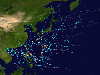
The 2003 Pacific typhoon season was a slightly below average yearlong period of tropical cyclogenesis exhibiting the development of 45 tropical depressions, of which 21 became named storms; of those, 14 became typhoons. Though every month with the exception of February and March featured tropical activity, most storms developed from May through October. During the season, tropical cyclones affected the Philippines, Japan, China, the Korean Peninsula, Indochina, and various islands in the western Pacific.

The 2002 Pacific typhoon season was a slightly above average Pacific typhoon season, producing twenty-six named storms, fifteen becoming typhoons, and eight super typhoons. It had an ACE over 400 units, making it one of the most active seasons worldwide. It was an event in the annual cycle of tropical cyclone formation, in which tropical cyclones form in the western Pacific Ocean. The season ran throughout 2002, though most tropical cyclones typically develop between May and October. The season's first named storm, Tapah, developed on January 11, while the season's last named storm, Pongsona, dissipated on December 11. The season's first typhoon, Mitag, reached typhoon status on March 1, and became the first super typhoon of the year four days later.

The 2001 Pacific typhoon season was an average season with twenty-six named storms, sixteen typhoons and three super typhoons, with a near normal Accumulated Cyclone Energy (ACE) of 307.3 units. It ran year-round in 2001, with most tropical cyclones in the northwestern Pacific Ocean tending between May and November.
This timeline documents all events that have taken place during the 2007 Pacific typhoon season. This article is limited to the Western Pacific basin which is located north of the equator and between 100°E and the International Date Line. Systems that reach tropical storm intensity are assigned a name by the Japan Meteorological Agency (JMA). Tropical depressions that form within the basin are assigned a number with a "W" suffix by the Joint Typhoon Warning Center (JTWC). Additionally, the Philippine Atmospheric, Geophysical and Astronomical Services Administration (PAGASA) assigns names to tropical cyclones that either form in or move into its self defined area of responsibility, which runs from 135°E to 115°E and 5°N to 25°N.

The 2008 Pacific typhoon season was a below average season which featured 22 named storms, eleven typhoons, and two super typhoons. The season had no official bounds; it ran year-round in 2008, but most tropical cyclones tend to form in the northwestern Pacific Ocean between May and November. These dates conventionally delimit the period of each year when most tropical cyclones form in the northwestern Pacific Ocean.

Typhoon Fitow was the ninth named tropical storm of the 2007 Pacific typhoon season that made landfall in Japan. At its peak, it was thought to have been a minimal Category 2 typhoon by the JTWC, but was, in post-storm analysis, downgraded to a Category 1-equivalent typhoon by the Joint Typhoon Warning Center. The name Fitow was contributed by the Federated States of Micronesia, and is Yapese for a beautiful fragrant flower. The typhoon killed at least 2 people in Tokyo and was the first typhoon to hit the city since Typhoon Mawar in 2005. Damage from Fitow totaled to around 1 billion.

Typhoon Sepat, known in the Philippines as Super Typhoon Egay, was the eighth named tropical storm and the strongest tropical cyclone of the 2007 Pacific typhoon season, that affected the Philippines and made landfall in Taiwan and Fujian. Sepat originated on August 11 via a low-circulation center SE of Naha, Okinawa, and was named by the Japan Meteorological Agency as Sepat on August 12 and Egay in the Philippines by PAGASA as it entered the PAR. Sepat underwent an explosive intensification on the night of August 13, reaching peak intensity at Category 5-equivalent super typhoon intensity the following morning. The storm maintained its strength for 2 days, until it underwent an eyewall replacement cycle, just before he storm makes landfall in Taiwan on August 17 as a Category 3-equivalent typhoon. After crossing the Taiwanese strait, Sepat; already weakening into Category 1 status due to unfavorable conditions, made a second landfall in China on August 18, 2007. The storm persisted across Mainland China, as it transitioned into an extratropical cyclone on August 20, and Sepat, now an extratropical low continued through the Chinese mainland until it finally dissipated near Yunnan Province on August 24.

Typhoon Conson, known in the Philippines as Typhoon Frank, was the first of the record ten typhoons to impact Japan during the 2004 Pacific typhoon season. Developing out of a tropical depression near the northern Philippines in early June, Conson slowly traveled towards the north. Gradually strengthening, the storm reached typhoon status late on June 7 according to the Joint Typhoon Warning Center and several hours later according to the Japan Meteorological Agency. After turning towards the northeast, the typhoon brushed Taiwan and reached its peak intensity with 10-minute sustained winds of 150 km/h (90 mph) on June 9. After reaching its peak, Conson gradually weakened, passing through Okinawa before being downgraded to a tropical storm the next day. On June 11, the storm made landfall as a minimal tropical storm in the Kōchi Prefecture just before becoming extratropical. The extratropical remnants continued towards the northeast and were last mentioned on June 14 crossing the International Date Line.

Typhoon Melor, known in the Philippines as Super Typhoon Quedan, was a powerful typhoon that hit Japan in early October 2009, causing significant damage. As part of the 2009 Pacific typhoon season, Melor formed as a tropical depression on September 29 and rapidly intensified into a Category 4-equivalent typhoon just three days later. Subsequently, on October 4, Melor became the second Category 5-equivalent super typhoon to form in the season. During the next days, the typhoon would interact with Typhoon Parma southeast of Taiwan, causing Parma to be almost stationary over northern Luzon and drop near-records of rainfall there. Afterwards, Melor gradually weakened in its approach to Japan, making landfall on October 7. As the storm exited Japan during the next day, it transitioned into an extratropical cyclone. The remnants of Melor were absorbed by a newly-formed extratropical cyclone near Alaska, which strengthened significantly and impacted the West Coast of the United States on October 13.
The 2011 Pacific typhoon season was a below average season that produced a total of 21 named storms, 8 typhoons, and four super typhoons. This season was much more active than the previous season, although both seasons were below the Pacific typhoon average of 26. The season ran throughout 2011, though most tropical cyclone tend to develop between May and October. The season's first named storm, Aere, developed on May 7 while the season's last named storm, Washi dissipated on December 19.

The 2014 Pacific typhoon season was a slightly below average season in terms of named storms, but featured the highest amount of Category 5 typhoons since 1997. This was mainly due to a developing El Niño that favors multiple powerful storms to form in the basin. The season formed twenty-three tropical storms, eleven typhoons, eight super typhoons, and seven Category 5 typhoons. The season's peak months August and September saw minimal activity caused by an unusually strong and a persistent suppressing phase of the Madden–Julian oscillation (MJO). The season ran throughout 2014, though most tropical cyclones typically develop between May and October. The season began with the development of Tropical Storm Lingling on January 18, and ended after Tropical Storm Jangmi which dissipated on January 1 of the next year.

The 2018 Pacific typhoon season was at the time, the costliest Pacific typhoon season on record, until the record was beaten by the following year. The season was well above-average, producing twenty-nine storms, thirteen typhoons, seven super typhoons and six Category 5 tropical cyclones. The season ran throughout 2018, though most tropical cyclones typically develop between May and October. The season's first named storm, Bolaven, developed on January 3, while the season's last named storm, Man-yi, dissipated on November 28. The season's first typhoon, Jelawat, reached typhoon status on March 29, and became the first super typhoon of the year on the next day.

Typhoon Halong, known in the Philippines as Typhoon Inday, passed just south of Guam one week after Typhoon Chataan struck the island and left heavy damage. The seventh named storm of the season, Halong developed near the same location as Chataan on July 5 near the Marshall Islands. For much of its duration, the storm moved toward the northwest, gradually intensifying. Early on July 10, Halong passed just south of Guam as a tropical storm, producing high waves and gusty winds on the island. The storm disrupted relief efforts from Chataan, causing additional power outages but little damage.

Most of the tropical cyclones of the 2013 Pacific typhoon season formed between May and November of that year. The scope of this article is the Pacific Ocean north of the equator, between 100°E and the International Date Line. Tropical storms which form in the Western Pacific basin are assigned a name by the Japan Meteorological Agency (JMA). Tropical depressions forming in this basin are given a number with a "W" suffix by the United States' Joint Typhoon Warning Center (JTWC). The Philippine Atmospheric, Geophysical and Astronomical Services Administration (PAGASA) assigns names to tropical cyclones that enter or form in the Philippine area of responsibility, but these names are not in common use outside the Philippines.

Typhoon Halong, known in the Philippines as Super Typhoon Jose, was an intense Typhoon in the Western Pacific basin in August 2014. It was the twelfth named storm and the fifth typhoon of the 2014 Pacific typhoon season. The storm reached its maximum intensity as a Category 5 super typhoon, making it the fifth strongest storm of the season, surpassed by Genevieve, Vongfong, Nuri and Hagupit.

Typhoon Toraji, known in the Philippines as Typhoon Isang, was one of the deadliest tropical cyclones to hit the island country of Taiwan, since 1961. The eight named storm and the third typhoon of the 2001 Pacific typhoon season, Toraji's origins were from an area of convection that persisted to the west of Guam. Moving north-northwest over favorable conditions, the disturbance intensified to a tropical depression, while the JTWC issued a TCFA on the newly developed system. On July 26, the depression entered the Philippine Area of Responsibility, with the PAGASA naming it Isang. Strong easterly wind shear inhibited further development; however, as the shear relaxed, both the JTWC and PAGASA upgraded the system to a tropical storm with also the JMA following suit hours later. Now named Toraji, the storm slowly intensified, reaching typhoon status on the next day. Toraji continued to gain strength until it made landfall as a Category 2 typhoon near Taipei on July 29. Despite the rugged terrains of the country, the JTWC upgraded the system further to a Category 3, shortly before weakening as it moved offshore on Taiwan Strait. The JMA and PAGASA downgraded the typhoon to a tropical storm, with the latter issuing their final advisory as it moved out of their AOR. It continued to weaken, with the JTWC also downgrading the system to a tropical storm, before making landfall near Fuzhou on July 31 before it was last noted by the next day.

Typhoon Songda, known in the Philippines as Super Typhoon Chedeng, was the strongest tropical cyclone worldwide in 2011. It caused moderate damage in the Philippines when it paralleled the country to the east as a Category 5–equivalent super typhoon; it later affected Taiwan and Japan as a weakening system. The fourth tropical depression, second named storm and the first super typhoon of the 2011 Pacific typhoon season, Songda formed from a non-tropical low that was embedded from the Intertropical Convergence Zone on May 17. An area of low-pressure subsequently formed and became organized for the JTWC to issue a TCFA on the system and the JMA to issue advisories, before both agencies declared it a tropical storm, earning the name Songda. Under favorable conditions, Songda slowly intensified as it entered the Philippine Area of Responsibility, with the PAGASA naming it Chedeng on May 23. On the next day, the three agencies declared the system a typhoon before rapidly intensifying to a super typhoon over the Philippine Sea. As it entered an unfavorable environment for further strengthening, Songda slowly weakened as it passed near Taiwan, before becoming extratropical near Japan. The remnants of the system slowly moved to the northeast, before absorbing to another extratropical cyclone to the south of Alaska.


