Typhoon Krosa (2007)

Last updated
Map key
  Tropical depression (≤38 mph, ≤62 km/h)
  Tropical storm (39–73 mph, 63–118 km/h)
  Category 1 (74–95 mph, 119–153 km/h)
  Category 2 (96–110 mph, 154–177 km/h)
  Category 3 (111–129 mph, 178–208 km/h)
  Category 4 (130–156 mph, 209–251 km/h)
  Category 5 (≥157 mph, ≥252 km/h)
  Unknown
Storm type
Disc Plain black.svg Tropical cyclone
Solid black.svg Subtropical cyclone
ArrowUp.svg Extratropical cyclone, remnant low, tropical disturbance, or monsoon depression

In late September, a new system formed east of the Philippines, leading to a Tropical Cyclone Formation Alert by JTWC. [3] PAGASA declared it a tropical depression and assigned a local name Ineng early on October 1, and the JMA [4] and JTWC [5] soon followed.

It was upgraded to a tropical storm early on October 2 by JMA, receiving the international name Krosa . [4] Rapid intensification took place on October 2 and it was upgraded to a typhoon by the JTWC by midday. [5] As it intensified, it gained a wide, ragged eye and began to track to the west, becoming a typhoon by the JMA early on October 3. It continued to rapidly intensify that day before leveling off as a Category 4-equivalent typhoon on October 4. [3] Fluctuations in intensity soon followed as Krosa approached Taiwan, as the JMA upgraded it to 105 knots (194 km/h) and the JTWC into a super typhoon early on October 5. [4] [5] It slowly weakened afterward before making landfall in northeastern Taiwan on October 6. After landfall in Taiwan, Krosa quickly weakened into Category 1 typhoon as it approached China. [5] Krosa would make landfall shortly afterwards between Zhejiang and Fujian around that intensity. JMA downgraded Krosa into a severe tropical storm. [4] Early on October 7, JMA would further downgrade Krosa into a tropical storm, [4] and JTWC followed suit, as Krosa weakened rapidly. [5] Krosa would parallel the coast of China as it turned east-northeast, and emerged in the sea soon after. As sea surface temperatures were cold and could not sustain a tropical cyclone, Krosa began transitioning into an extratropical cyclone. [3] Around noon October 8, JMA published the last tropical cyclone warning on Krosa as it weakened into a tropical depression, and JTWC followed suit six hours later. [3] The extratropical remnants of Krosa crossed the International Dateline on October 12.

Preparations

Taiwan

Hundreds of thousands of people had to evacuate from the oncoming typhoon. Several flights and transport services were cancelled due to the disruption of the typhoon. [6]

China

An evacuation of 730,000 people from China's Zhejiang and Fujian provinces was ordered on the evening of October 6. [7] More than 600,000 people evacuated after landfall in China, bringing the total evacuees into 1.4 million people. In Shanghai, 8,800 workers had to stay out of the coasts despite Krosa passing well south of the city, and more than 40 flights to Shanghai were cancelled. [8]

Impact

Destroyed sports gym in Taiwan Yi Lan Gao Zhong Yin Tai Feng Zao Cheng Huo Dong Zhong Xin Tan Ta .jpg
Destroyed sports gym in Taiwan

Taiwan

Rains from Krosa caused flooding which led to blocked roads along with downed trees. These blocked roads caused the death of a newborn who needed medical attention. Another death was directly caused by landfall, [2] [6] while isolated incidents caused by high winds from the typhoon caused deaths of another two people. [2] Taiwan's National Fire Agency reported that a traffic incident caused another death, bringing the death toll to five people. [2] Additionally, Krosa injured 67 people and knocked out power to another 2 million people when it made landfall as a Category 4 typhoon. [2]

China

In China, severe structural damage and power outages were reported in the port city of Wenzhou, and 17 people were reported injured. No fatalities were reported. [2] According to Government of China, more than 7.4 million people were affected by the typhoon. Rains and winds from Krosa caused the destruction of 3,500 homes. [8]

See also

Related Research Articles

<span class="mw-page-title-main">2005 Pacific typhoon season</span> Typhoon season in the Western Pacific Ocean

The 2005 Pacific typhoon season was the least active typhoon season since 2000, producing 23 named storms, of which 13 became typhoons. It was an event in the annual cycle of tropical cyclone formation, in which tropical cyclones form in the western Pacific Ocean. The season ran throughout 2005, though most tropical cyclones typically develop between May and October. The season's first named storm, Kulap, developed on January 13, while the season's last named storm, Bolaven, dissipated on November 20. The season's first typhoon, Haitang, reached typhoon status on July 13, and became the first super typhoon of the year three days later.

<span class="mw-page-title-main">2006 Pacific typhoon season</span> Typhoon season in the Western Pacific Ocean

The 2006 Pacific typhoon season was a below-average season that produced a total of 23 named storms, 15 typhoons, and six super typhoons. The season ran throughout 2006, though most tropical cyclones typically develop between May and October. The season's first named storm, Chanchu, developed on May 9, while the season's last named storm, Trami, dissipated on December 20.

<span class="mw-page-title-main">2007 Pacific typhoon season</span> Typhoon season in the Western Pacific Ocean

The 2007 Pacific typhoon season was a below average season which featured 24 named storms, fourteen typhoons, and five super typhoons. It was an event in the annual cycle of tropical cyclone formation, in which tropical cyclones form in the western Pacific Ocean. The season ran throughout 2007, though most tropical cyclones typically develop between May and November. The season's first named storm, Kong-rey, developed on March 30, while the season's last named storm, Mitag, dissipated on November 27. The season's first typhoon, Yutu, reached typhoon status on May 18, and became the first super typhoon of the year on the next day.

<span class="mw-page-title-main">2004 Pacific typhoon season</span> Typhoon season in the Western Pacific Ocean

The 2004 Pacific typhoon season was an extremely active season that featured the second-highest ACE ever recorded in a single season, second only to 1997, which featured 29 named storms, nineteen typhoons, and six super typhoons. It was an event in the annual cycle of tropical cyclone formation, in which tropical cyclones form in the western Pacific Ocean. The season ran throughout 2004, though most tropical cyclones typically develop between May and October. The season's first named storm and also the first typhoon, Sudal, developed on April 4, later was reached typhoon status two days later, and became the first super typhoon of the year three days later. The season's last named storm, Noru, dissipated on December 21.

<span class="mw-page-title-main">2003 Pacific typhoon season</span> Typhoon season in the Western Pacific Ocean

The 2003 Pacific typhoon season was a slightly below average yearlong period of tropical cyclogenesis exhibiting the development of 45 tropical depressions, of which 21 became named storms; of those, 14 became typhoons. Though every month with the exception of February and March featured tropical activity, most storms developed from May through October. During the season, tropical cyclones affected the Philippines, Japan, China, the Korean Peninsula, Indochina, and various islands in the western Pacific.

<span class="mw-page-title-main">2001 Pacific typhoon season</span> Typhoon season in the Western Pacific Ocean

The 2001 Pacific typhoon season was the fourth and final consecutive year with below-average activity, making it the lowest four-year period of activity since 1976–1979, due to the presence of a strong La Niña that had persisted from 1998 to 2001. However, it was more active than the previous seasons, producing twenty-five named storms, sixteen typhoons and three super typhoons, with a near normal Accumulated Cyclone Energy (ACE) of 307.3 units. It ran year-round in 2001, with most tropical cyclones in the northwestern Pacific Ocean tending between May and November.

<span class="mw-page-title-main">1999 Pacific typhoon season</span> Typhoon season in the Western Pacific Ocean

The 1999 Pacific typhoon season was the last Pacific typhoon season to use English names as storm names. It was a very inactive season, featuring the lowest number of typhoons on record, five. It had no official bounds; it ran year-round in 1999, but most tropical cyclones tend to form in the northwestern Pacific Ocean between May and November. These dates conventionally delimit the period of each year when most tropical cyclones form in the northwestern Pacific Ocean.

<span class="mw-page-title-main">1992 Pacific typhoon season</span> Typhoon season in the Western Pacific Ocean

The 1992 Pacific typhoon season had no official bounds; it ran year-round in 1992. Despite this, most tropical cyclones tend to form in the northwestern Pacific Ocean between May and November. These dates conventionally delimit the period of each year when most tropical cyclones form in the northwestern Pacific Ocean.

<span class="mw-page-title-main">1988 Pacific typhoon season</span> Typhoon season in the Pacific Ocean

The 1988 Pacific typhoon season had no official bounds; it ran year-round in 1988, but most tropical cyclones tend to form in the northwestern Pacific Ocean between May and November. These dates conventionally delimit the period of each year when most tropical cyclones form in the northwestern Pacific Ocean. Tropical Storms formed in the entire west Pacific basin were assigned a name by the Joint Typhoon Warning Center. Tropical depressions that enter or form in the Philippine area of responsibility are assigned a name by the Philippine Atmospheric, Geophysical and Astronomical Services Administration or PAGASA. This can often result in the same storm having two names.

<span class="mw-page-title-main">Typhoon Sepat</span> Pacific typhoon in 2007

Typhoon Sepat, known in the Philippines as Super Typhoon Egay, was the eighth named tropical storm and the strongest tropical cyclone of the 2007 Pacific typhoon season, that affected the Philippines and made landfall in Taiwan and Fujian. Sepat originated on August 11 via a low-circulation center SE of Naha, Okinawa, and was named by the Japan Meteorological Agency as Sepat on August 12 and Egay in the Philippines by PAGASA as it entered the PAR. Sepat underwent an explosive intensification on the night of August 13, reaching peak intensity at Category 5-equivalent super typhoon intensity the following morning. The storm maintained its strength for 2 days, until it underwent an eyewall replacement cycle, just before he storm makes landfall in Taiwan on August 17 as a Category 3-equivalent typhoon. After crossing the Taiwanese strait, Sepat; already weakening into Category 1 status due to unfavorable conditions, made a second landfall in China on August 18, 2007. The storm persisted across Mainland China, as it transitioned into an extratropical cyclone on August 20, and Sepat, now an extratropical low continued through the Chinese mainland until it finally dissipated near Yunnan Province on August 24.

<span class="mw-page-title-main">Typhoon Kalmaegi (2008)</span> Pacific typhoon in 2008

Typhoon Kalmaegi, known in the Philippines as Typhoon Helen, was the seventh named storm and the fifth typhoon that was recognised by the Japan Meteorological Agency. The Joint Typhoon Warning Center also recognised it as the eighth tropical depression, the seventh tropical storm and the sixth typhoon of the 2008 Pacific typhoon season.

<span class="mw-page-title-main">2010 Pacific typhoon season</span> Typhoon season in the Western Pacific Ocean

The 2010 Pacific typhoon season, with 14 named storms is the least active Pacific typhoon season on record. Seven of them strengthened into typhoons while one reached super typhoon intensity. The Pacific typhoon season during 2010 was in fact less active than the 2010 Atlantic hurricane season, with only two other occurrences of that happening, 2005 and 2020. In the same year, the Pacific hurricane season broke the same record being the least active season on record. During the season, no storms made landfall in mainland Japan, only the second such occurrence since 1988. Also, all of the 14 named storms developed west of 150°E.

<span class="mw-page-title-main">Typhoon Wipha (2007)</span> Pacific typhoon in 2007

Typhoon Wipha, known in the Philippines as Typhoon Goring, was the strongest typhoon to threaten the Chinese coastline since Typhoon Saomai in August 2006. Forming out of a tropical disturbance on September 15, 2007, it quickly developed into a tropical storm, and intensified into a typhoon the following day with the appearance of an eye feature. After a period of rapid intensification, Wipha attained its peak intensity on September 18, with winds of 185 km/h (115 mph) and a barometric pressure of 925 mbar (hPa), according to the Japan Meteorological Agency. Later that day, the storm began to weaken as it interacted with the mountainous terrain of Taiwan before brushing the northern edge of the island. Wipha subsequently made landfall near Fuding along the Fujian–Zhejiang provincial border with winds estimated at 185 km/h (115 mph) by the JTWC. Shortly thereafter, the typhoon weakened as it moved inland, weakening to a tropical storm within 18 hours of moving over land.

<span class="mw-page-title-main">2013 Pacific typhoon season</span> Typhoon season in the Western Pacific Ocean

The 2013 Pacific typhoon season was the most active Pacific typhoon season since 2004, and the deadliest since 1975 Pacific typhoon season. It featured one of the most powerful storm in history. It was an above-average season with 31 named storms, 13 typhoons, and five super typhoons. The season's first named storm, Sonamu, developed on January 4 while the season's last named storm, Podul, dissipated on November 15. Most of the first seventeen named storms before mid-September were relatively weak, as only two of them reached typhoon intensity. Total damage amounted to at least $26.41 billion (USD), making it the third costliest Pacific typhoon season on record; behind 2018 Pacific typhoon season and 2019 Pacific typhoon season.

<span class="mw-page-title-main">2014 Pacific typhoon season</span> Typhoon season in the Western Pacific Ocean

The 2014 Pacific typhoon season was a slightly below average season, featuring 23 tropical storms, 11 typhoons, 8 super typhoons, and 7 Category 5 typhoons. The season's peak months August and September saw minimal activity caused by an unusually strong and a persistent suppressing phase of the Madden–Julian oscillation (MJO). The season ran throughout 2014, though most tropical cyclones typically develop between May and October. The season began with the development of Tropical Storm Lingling on January 18, and ended after Tropical Storm Jangmi which dissipated on January 1 of the next year.

<span class="mw-page-title-main">2019 Pacific typhoon season</span> Typhoon season in the Western Pacific Ocean

The 2019 Pacific typhoon season was the costliest Pacific typhoon season on record, just ahead of the previous year. The season featured fairly above-average tropical cyclone activity for the second consecutive year, producing 29 named storms, 17 typhoons, and five super typhoons. The season's first named storm, Pabuk, reached tropical storm status on January 1, becoming the earliest-forming tropical storm of the western Pacific Ocean on record, breaking the previous record that was held by Typhoon Alice in 1979. The season's first typhoon, Wutip, reached typhoon status on February 20. Wutip further intensified into a super typhoon on February 23, becoming the strongest February typhoon on record, and the strongest tropical cyclone recorded in February in the Northern Hemisphere. The season's last named storm, Phanfone, dissipated on December 29 after it made landfall in the Philippines.

<span class="mw-page-title-main">Timeline of the 2013 Pacific typhoon season</span>

Most of the tropical cyclones of the 2013 Pacific typhoon season formed between May and November of that year. The scope of this article is the Pacific Ocean north of the equator, between 100°E and the International Date Line. Tropical storms which form in the Western Pacific basin are assigned a name by the Japan Meteorological Agency (JMA). Tropical depressions forming in this basin are given a number with a "W" suffix by the United States' Joint Typhoon Warning Center (JTWC). The Philippine Atmospheric, Geophysical and Astronomical Services Administration (PAGASA) assigns names to tropical cyclones that enter or form in the Philippine area of responsibility, but these names are not in common use outside the Philippines.

<span class="mw-page-title-main">Typhoon Joan (1959)</span> Pacific typhoon in 1959

Typhoon Joan was an intense typhoon that caused minor damages in relative to the strength of the typhoon. Joan was the strongest typhoon of 1959 Pacific typhoon season, and one of the most intense Pacific typhoons on record. Joan formed from a surface center to the northeast of Guam on August 23, in which Japan Meteorological Agency began to track and classify the system as a tropical depression on the next day. A reconnaissance aircraft was sent to investigate the surface center and in 03:25 UTC on August 25 the surface center was classified as a tropical storm by Joint Typhoon Warning Center. The storm rapidly intensified into a typhoon in the same day it was formed. By the next three days as Joan tracks towards Taiwan, Joan explosively intensified to attain peak intensity with the pressure of 885 millibars (26.1 inHg), which is tied with Nina as the most intense Pacific typhoon on the record at the time. Shortly afterwards, Joan attained peak strength as a Category 5 equivalent typhoon on the Saffir–Simpson hurricane scale with winds of 165 knots (190 mph) before making landfall in Taiwan as a 160 knots (180 mph) typhoon, which was according to JTWC is the strongest landfall in the recorded history at the time. After making landfall, Joan weakened into a 110 knots (130 mph) typhoon before making landfall on Fujian, China as a Category 2 equivalent typhoon on the Saffir–Simpson hurricane scale with winds of 95 knots (109 mph). Once onshore, Joan did not degenerate quickly as Joan remained as a tropical cyclone for about one day before transitioning into a extratropical cyclone in 18:00 UTC of August 31. Extratropical remnants of Joan quickly traversed through South Korea and Japan before being last noted on 18:00 UTC, September 2.

<span class="mw-page-title-main">Typhoon Maria (2018)</span> Pacific typhoon in 2018

Typhoon Maria, known in the Philippines as Typhoon Gardo, was a powerful tropical cyclone that affected Guam, the Ryukyu Islands, Taiwan, and East China in early July 2018. Developing into the eighth named tropical storm of the 2018 Pacific typhoon season and passing the Mariana Islands on July 4, Maria strengthened into the fourth typhoon of the season and underwent rapid intensification the next day amid favorable environmental conditions. The typhoon reached its first peak intensity on July 6; subsequently, Maria weakened due to an eyewall replacement cycle, but it reintensified and reached a second, stronger peak intensity on July 9 with 10-minute sustained winds of 195 km/h (121 mph) and a minimum pressure of 915 hPa. Over the next three days, it started to gradually weaken due to another eyewall replacement cycle and decreasing sea surface temperatures. After crossing the Yaeyama Islands and passing north of Taiwan on July 10, Maria ultimately made landfall over Fujian, China, early on July 11, before dissipating the next day.

<span class="mw-page-title-main">Typhoon Hagupit (2020)</span> Pacific typhoon in 2020

Typhoon Hagupit, known in the Philippines as Severe Tropical Storm Dindo, was a Category 1 typhoon that heavily impacted Eastern China and South Korea in August 2020. It was the fourth named storm and the second typhoon of the annual typhoon season. The JMA began monitoring a tropical depression that developed in the Philippine Sea on July 30, with PAGASA assigning the name “Dindo” to the storm, later that day it strengthened into a tropical storm, according to the JMA. PAGASA issued its final advisory on Dindo early on August 3, as it moved out of their area of responsibility. Hagupit intensified into a typhoon on August 3, before making landfall in Wenzhou, China at 19:30 UTC that day at peak intensity. Hagupit subsequently weakened over China, before degenerating into an extratropical low on August 5. Hagupit's remnants persisted for another several days, as the storm moved eastward, before dissipating south of Alaska on August 14.

References

  1. FlorCruz, Jaime. "People, politics ease China's disaster evacuation efforts". CNN . Retrieved 4 October 2020.
  2. 1 2 3 4 5 6 "Typhoon hits China, then weakens to storm". Reuters. October 7, 2007.
  3. 1 2 3 4 "Significant Tropical Weather Advisory for the Western and South Pacific Oceans". Joint Typhoon Warning Center. October 1, 2007. Retrieved October 4, 2020.
  4. 1 2 3 4 5 "Annual Report on Activities of the RSMC Tokyo — Typhoon Center 2007" (PDF). Japan Meteorological Agency. September 27, 2008. Retrieved October 4, 2020.
  5. 1 2 3 4 5 Joint Typhoon Warning Center (2008). "Super Typhoon 17W (Krosa) Best Track" . Retrieved October 4, 2020.
  6. 1 2 "Após deixar 5 mortos em passagem por Taiwan, tufão "Krosa" chega à China". noticias.uol.com.br (in Portuguese).
  7. "After Pounding Taiwan, Typhoon Krosa Approaches Coast of China". Voice of America News. October 6, 2007. Archived from the original on October 11, 2007. Retrieved October 6, 2007.
  8. 1 2 "Tropical Storm Krosa back to sea, but rains continue in east China". news.xinhuanet.com. Archived from the original on 2012-10-10.
Typhoon Krosa (Ineng)
Krosa 05 oct 2007 0215Z.jpg
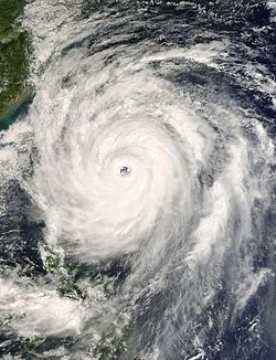
Typhoon Krosa approaching Taiwan on October 5