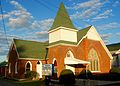
Unionville Historic District | |
 Unionville Historic District, May 2010 | |
  | |
| Location | U.S. Route 220 and Pennsylvania Route 504, Unionville, Pennsylvania |
|---|---|
| Coordinates | 40°54′22″N77°52′34″W / 40.90611°N 77.87611°W |
| Area | 120 acres (49 ha) |
| Built | 1848 |
| Architectural style | Mid 19th Century Revival, Italianate, Georgian |
| NRHP reference No. | 79002194 [1] |
| Added to NRHP | May 30, 1979 |
The Unionville Historic District is a national historic district that is located in Unionville, Centre County, Pennsylvania.
Contents
It was added to the National Register of Historic Places in 1979. [1]