
The Netherlands Antilles, also known as the Dutch Antilles, was a constituent Caribbean country of the Kingdom of the Netherlands consisting of the islands of Saba, Sint Eustatius, and Sint Maarten in the Lesser Antilles, and Aruba, Curaçao, and Bonaire in the Leeward Antilles. The country came into being in 1954 as the autonomous successor of the Dutch colony of Curaçao and Dependencies, and it was dissolved in 2010, when like Aruba in 1986, Sint Maarten and Curaçao gained status of constituent countries within the Kingdom of the Netherlands, and Saba, Sint Eustatius, and Bonaire gained status of special municipality of Netherlands as the Caribbean Netherlands. The neighboring Dutch colony of Surinam in continental South America, did not become part of the Netherlands Antilles but became a separate autonomous country in 1954. All the territories that belonged to the Netherlands Antilles remain part of the kingdom today, although the legal status of each differs. As a group they are still commonly called the Dutch Caribbean, regardless of their legal status. People from this former territory continue to be called Antilleans in the Netherlands.
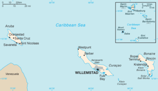
The Netherlands Antilles was a constituent country in the Caribbean Sea. It consisted of two island groups, the ABC islands Curaçao, Bonaire and Aruba just north of Venezuela, and the SSS islands east of the Virgin Islands.
A dependent territory, dependent area, or dependency is a territory that does not possess full political independence or sovereignty as a sovereign state and remains politically outside the controlling state's integral area. As such, a dependent territory includes a range of non-integrated not fully to non-independent territory types, from associated states to non-self-governing territories.

Sint Eustatius, known locally as Statia, is an island in the Caribbean. It is a special municipality of the Netherlands.

The SSS islands, locally also known as the Windward Islands, is a collective term for the three territories of the Dutch Caribbean that are located within the Leeward Islands group of the Lesser Antilles in the Caribbean Sea. In order of population size, they are: Sint Maarten, Sint Eustatius, and Saba. In some contexts, the term is also used to refer to the entire island of Saint Martin, alongside Sint Eustatius and Saba.

The West Indies is a subregion of North America, surrounded by the North Atlantic Ocean and the Caribbean Sea, which comprises 13 independent island countries and 19 dependencies in three archipelagos: the Greater Antilles, the Lesser Antilles, and the Lucayan Archipelago, including the English-speaking countries and territories in the wider region, such as Guyana and Belize.

The United Nations geoscheme is a system which divides 248 countries and territories in the world into six continental regions, 22 geographical subregions, and two intermediary regions. It was devised by the United Nations Statistics Division (UNSD) based on the M49 coding classification. The creators note that "the assignment of countries or areas to specific groupings is for statistical convenience and does not imply any assumption regarding political or other affiliation of countries or territories".
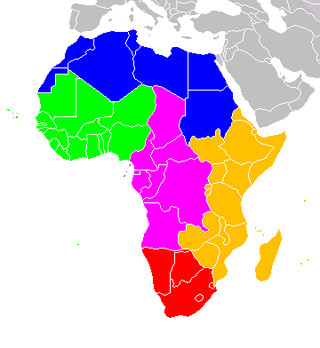
The following is an alphabetical list of subregions in the United Nations geoscheme for Africa, used by the United Nations and maintained by the UNSD department for statistical purposes.

The Netherlands Antilles was an autonomous Caribbean country within the Kingdom of the Netherlands. It was dissolved on 10 October 2010.
The Caribbean Tourism Organization's main objective is the development of sustainable tourism for the economic and social benefit of Caribbean people.
The Catholic Church in the Caribbean part of the Kingdom of the Netherlands is part of the worldwide Roman Catholic Church, under the spiritual leadership of the Pope in Rome.

The following is an alphabetical list of subregions in the United Nations geoscheme for Europe, created by the United Nations Statistics Division (UNSD). The scheme subdivides the continent into Eastern Europe, Northern Europe, Southern Europe, and Western Europe. The UNSD notes that "the assignment of countries or areas to specific groupings is for statistical convenience and does not imply any assumption regarding political or other affiliation of countries or territories".

The United Nations geoscheme for Oceania is an internal tool created and used by the UN's Statistics Division (UNSD) for the specific purpose of UN statistics.

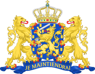
The Kingdom of the Netherlands, commonly known simply as the Netherlands, is a sovereign state consisting of a collection of constituent territories united under the monarch of the Netherlands, who functions as head of state. The realm is not a federation; it is a unitary monarchy with its largest subdivision, the eponymous Netherlands, predominantly located in Northwestern Europe and with several smaller island territories located in the Caribbean.

The following is an alphabetical list of topics related to the former nation of the Netherlands Antilles.

The Caribbean Netherlands is a geographic region of the Netherlands located outside of Europe, in the Caribbean, consisting of three special municipalities. These are the islands of Bonaire, Sint Eustatius, and Saba, as they are also known in legislation, or the BES islands for short. The islands are officially classified as public bodies in the Netherlands and as overseas territories of the European Union; as such, European Union law does not automatically apply to them.
A common visa exists since the end of 2010 for the territories of Aruba, Curaçao, Sint Maarten and the Caribbean Netherlands which form together the territory of the Kingdom of the Netherlands in the Caribbean. The visa is not valid for the European part of the Netherlands, which is part of the Schengen Area.
The Dutch Caribbean are the New World territories, colonies, and countries of the Dutch Empire and the Kingdom of the Netherlands located in the Caribbean Sea, mainly the northern and southwestern regions of the Lesser Antilles archipelago.

The term Latin America and the Caribbean (LAC) is an English-language acronym referring to the Latin American and the Caribbean region. The term LAC covers an extensive region, extending from The Bahamas and Mexico to Argentina and Chile. The region has over 670,230,000 people as of 2016, and spanned for 21,951,000 square kilometres (8,475,000 sq mi).
Same-sex marriage has been legal in Bonaire, Sint Eustatius and Saba since 10 October 2012, the effective date of legislation passed by the States General of the Netherlands enabling same-sex couples to marry. The Caribbean Netherlands was the first jurisdiction in the Caribbean to legalise same-sex marriage, and was followed a few months later by French territories, including Guadeloupe and Martinique, in May 2013.
