United Nations geoscheme for Oceania

Last updated

The United Nations geoscheme for Oceania is an internal tool created and used by the UN's Statistics Division (UNSD) for the specific purpose of UN statistics. [1]

Contents

Oceania

Oceania UN Geoscheme Regions.svg
UN geoscheme subregions of Oceania

Area8,525,989 km2 (3,291,903 sq mi)
Population41,570,842 (2018, 6th)
DemonymOceanian
Countries 14 (sovereign)
2 (associated)
Dependencies 21
Time Zones UTC+14 (Kiribati) to UTC-11 (American Samoa and Niue) (West to East)
Largest Cities Flag of Australia (converted).svg Sydney
Flag of Australia (converted).svg Melbourne
Flag of Australia (converted).svg Brisbane
Flag of Australia (converted).svg Perth
Flag of New Zealand.svg Auckland
Flag of Australia (converted).svg Adelaide
Flag of Australia (converted).svg Gold Coast
Flag of Australia (converted).svg Newcastle
Flag of Australia (converted).svg Canberra
Flag of New Zealand.svg Wellington

The following is an alphabetical list of subregions as defined by the UNSD geoscheme. [1]

UN Subregions

Oceania with its sovereign and dependent islands within the subregions Melanesia, Micronesia, Polynesia and Australasia Oceania UN Geoscheme - Map with Zones.svg
Oceania with its sovereign and dependent islands within the subregions Melanesia, Micronesia, Polynesia and Australasia

The United Nations geoscheme subdivides the region into Australia and New Zealand, Melanesia, Micronesia, and Polynesia. The UNSD notes that "the assignment of countries or areas to specific groupings is for statistical convenience and does not imply any assumption regarding political or other affiliation of countries or territories". [1] The number between parentheses is the UN M49 code (009 for the whole of Oceania).

SubregionCountry/Territory and capital city [note 1]
Australia and New Zealand (053) Flag of Australia (converted).svg  Australia (036) – Commonwealth of Australia
Capital: Canberra
Flag of Christmas Island.svg  Christmas Island (162) – Territory of Christmas Island (Australia)
Capital: Flying Fish Cove
Flag of the Cocos (Keeling) Islands.svg  Cocos (Keeling) Islands (166) – Territory of Cocos (Keeling) Islands (Australia)
Capital: West Island
Flag of Australia (converted).svg  Heard Island and McDonald Islands (334) – Territory of Heard Island and McDonald Islands (Australia)
Flag of New Zealand.svg  New Zealand (554)
Capital: Wellington
Flag of Norfolk Island.svg  Norfolk Island (174) – Territory of Norfolk Island (Australia)
Capital: Kingston
Melanesia (054) Flag of Fiji.svg  Fiji (242) – Republic of Fiji
Capital: Suva
Flag of FLNKS.svg  New Caledonia (540) (France)
Capital: Nouméa
Flag of Papua New Guinea.svg  Papua New Guinea (598) – Independent State of Papua New Guinea
Capital: Port Moresby
Flag of the Solomon Islands.svg  Solomon Islands (090)
Capital: Honiara
Flag of Vanuatu.svg  Vanuatu (548) – Republic of Vanuatu
Capital: Port Vila
Micronesia (057) Flag of Guam.svg  Guam (316) (United States)
Capital: Hagåtña
Flag of Kiribati.svg  Kiribati (296) – Republic of Kiribati
Capital: South Tarawa
Flag of the Marshall Islands.svg  Marshall Islands (584) – Republic of the Marshall Islands
Capital: Majuro
Flag of the Federated States of Micronesia.svg  Micronesia (583) – Federated States of Micronesia
Capital: Palikir
Flag of Nauru.svg  Nauru (520) – Republic of Nauru
Capital: Yaren (unofficial, seat of parliament)
Flag of the Northern Mariana Islands.svg  Northern Mariana Islands (580) – Commonwealth of the Northern Mariana Islands (United States)
Capital: Saipan
Flag of Palau.svg  Palau (585) – Republic of Palau
Capital: Ngerulmud
Flag of the United States (DoS ECA Color Standard).svg  United States Minor Outlying Islands (581) (United States) [note 2]
Capital: Washington, D.C. (administrative centre)
Polynesia (061) Flag of American Samoa.svg  American Samoa (016) (United States)
Capital: Pago Pago
Flag of the Cook Islands.svg  Cook Islands (184) (New Zealand) [3]
Capital: Avarua
Flag of French Polynesia.svg  French Polynesia (258) (France)
Capital: Pape'ete
Flag of Niue.svg  Niue (570) (New Zealand) [4]
Capital: Alofi
Flag of the Pitcairn Islands.svg  Pitcairn (612) – Pitcairn, Henderson, Ducie and Oeno Islands (United Kingdom)
Capital: Adamstown
Flag of Samoa.svg  Samoa (882) – Independent State of Samoa
Capital: Apia
Flag of Tokelau.svg  Tokelau (772) (New Zealand)
Capital: Fakaofo
Flag of Tonga.svg  Tonga (776) – Kingdom of Tonga
Capital: Nukuʻalofa
Flag of Tuvalu.svg  Tuvalu (798)
Capital: Funafuti
Flag of Wallis and Futuna.svg  Wallis and Futuna (876) – Territory of the Wallis and Futuna Islands (France)
Capital: Mata-Utu

See also

Notes

  1. Subregions and countries/territories as per the United Nations geoscheme.
  2. The United Nations geoscheme has included the United States Minor Outlying Islands in Micronesia despite most of its islands are located in Polynesia geographically. Wake Island is the only island in the territory located in Micronesia. Navassa Island in the Caribbean Sea has been excluded from this territory by the UN geoscheme. This disputed island has not been included in the Caribbean subregion either. [2]

Related Research Articles

<span class="mw-page-title-main">Subregion</span> Part of a larger geographic region or continent

A subregion is a part of a larger region or continent. Cardinal directions are commonly used to define subregions. There are many criteria for creating systems of subregions; this article is focusing on the UN statistical geoscheme, which is a changing, constantly updated, UN tool based on specific political geography considerations relevant in UN statistics.

<span class="mw-page-title-main">Geography of Asia</span>

Geography of Asia reviews geographical concepts of classifying Asia, the central and eastern part of Eurasia, comprising 58 countries and territories.

The United Nations Statistics Division (UNSD), formerly the United Nations Statistical Office, serves under the United Nations Department of Economic and Social Affairs (DESA) as the central mechanism within the Secretariat of the United Nations to supply the statistical needs and coordinating activities of the global statistical system. The Division is overseen by the United Nations Statistical Commission, established in 1947, as the apex entity of the global statistical system and highest decision making body for coordinating international statistical activities. It brings together the Chief Statisticians from member states from around the world.

<span class="mw-page-title-main">United Nations geoscheme</span> UN system for grouping the worlds 248 countries and territories into regions and subregions

The United Nations geoscheme is a system which divides 248 countries and territories in the world into six continental regions, 22 geographical subregions, and two intermediary regions. It was devised by the United Nations Statistics Division (UNSD) based on the M49 coding classification. The creators note that "the assignment of countries or areas to specific groupings is for statistical convenience and does not imply any assumption regarding political or other affiliation of countries or territories".

<span class="mw-page-title-main">United Nations geoscheme for Africa</span> UN geographical categorizition of Africa

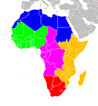
The following is an alphabetical list of subregions in the United Nations geoscheme for Africa, used by the United Nations and maintained by the UNSD department for statistical purposes.

<span class="mw-page-title-main">United Nations geoscheme for the Americas</span> United Nations geoscheme for North America and South America

The United Nations geoscheme for the Americas is an internal tool created and used by the UN's Statistics Division (UNSD) for the specific purpose of UN statistics.

UN M49 or the Standard Country or Area Codes for Statistical Use is a standard for area codes used by the United Nations for statistical purposes, developed and maintained by the United Nations Statistics Division. Each area code is a 3-digit number which can refer to a wide variety of geographical and political regions, like a continent and a country. Codes assigned in the system generally do not change when the country or area's name changes, but instead change when the territorial extent of the country or area changes significantly, although there have been exceptions to this rule.

<span class="mw-page-title-main">United Nations geoscheme for Europe</span>

The following is an alphabetical list of subregions in the United Nations geoscheme for Europe, created by the United Nations Statistics Division (UNSD). The scheme subdivides the continent into Eastern Europe, Northern Europe, Southern Europe, and Western Europe. The UNSD notes that "the assignment of countries or areas to specific groupings is for statistical convenience and does not imply any assumption regarding political or other affiliation of countries or territories".

<span class="mw-page-title-main">Boundaries between the continents</span>

Determining the boundaries between the continents is generally a matter of geographical convention. Several slightly different conventions are in use. The number of continents is most commonly considered seven but may range as low as four when Afro-Eurasia and the Americas are both considered as single continents. An island can be considered to be associated with a given continent by either lying on the continent's adjacent continental shelf or being a part of a microcontinent on the same principal tectonic plate. An island can also be entirely oceanic while still being associated with a continent by geology or by common geopolitical convention. Another example is the grouping into Oceania of the Pacific Islands with Australia and Zealandia.

<span class="mw-page-title-main">United Nations geoscheme for Asia</span> Alphabetical list of subregions in the United Nations geoscheme for Asia

The United Nations geoscheme for Asia is an internal tool created and used by the United Nations, maintained by the United Nations Statistics Division (UNSD) for the specific purpose of UN statistics. The scheme's subregions are presented here in alphabetical order. Its subregions may not coincide with other geographic categorization schemes.

<span class="mw-page-title-main">Outline of Oceania</span> Overview of and topical guide to Oceania

The following outline is provided as an overview and topical guide to Oceania.

The decolonisation of Oceania occurred after World War II when nations in Oceania achieved independence by transitioning from European colonial rule to full independence.

<span class="mw-page-title-main">Demographics of Oceania</span>

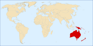
Oceania is a region centered on the islands of the tropical Pacific Ocean. Conceptions of what constitutes Oceania vary, with it being defined in various ways, often geopolitically or geographically. In the geopolitical conception used by the United Nations, International Olympic Committee, and many atlases, the Oceanic region includes Australia and the nations of the Pacific from Papua New Guinea east, but not the Malay Archipelago or Indonesian New Guinea. The term is sometimes used more specifically to denote Australasia as a geographic continent, or biogeographically as a synonym for either the Australasian realm or the Oceanian realm.

<span class="mw-page-title-main">Latin America and the Caribbean</span> Subregion of the Americas

The term Latin America and the Caribbean (LAC) is an English-language acronym referring to the Latin American and the Caribbean region. The term LAC covers an extensive region, extending from The Bahamas and Mexico to Argentina and Chile. The region has over 670,230,000 people as of 2016, and spanned for 21,951,000 square kilometres (8,475,000 sq mi).

Outlying Oceania is the name used in the Unicode Common Locale Data Repository for territories that are supplemented into the United Nations geoscheme for Oceania since they are not assigned to a subcontinent. The name has private-use region subtags assigned: alpha-2 QO, alpha-3 QOO and numeric 961.

References

  1. 1 2 3 United Nations Statistics Division – Standard Country and Area Codes Classifications. The UNSD notes that "the assignment of countries or areas to specific groupings is for statistical convenience".
  2. UNSD M49 Standard – Recent changes (see Note 11)
  3. CIA (2010-07-15). "Cook Islands at the CIA's page". CIA. Retrieved 2015-06-23.
  4. CIA (2010-07-15). "Niue at the CIA's page". CIA. Retrieved 2015-06-23.