University/Parks Trail

Last updated
University/Parks Trail
Universityparkstrail.jpg
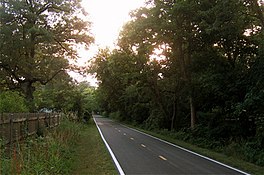
Section of the Trail between Holland-Sylvania Road and McCord Road
Length6.3 mi (10.1 km)
Location Lucas County, Ohio, USA
Trailheads University of Toledo to Sylvania, Ohio
UseMulti-use
Hiking details
Trail difficulty MUTCD D9-6.svg Wheelchair accessible [1]
SeasonYear-round
Sights Wildwood Preserve Metropark
Right of way Toledo, Angola and Western Railroad [2] [3]

The University/Parks Trail is a rail trail in metropolitan area of Toledo, Ohio, United States. The trail is open to walkers, bikers, joggers and in-line skaters.
Contents

Location

Map all coordinates using: OpenStreetMap  
Download coordinates as: KML

The entire route is in Lucas County.

LocationmikmDestinationsNotes
Sylvania Township −2.65−4.26 Quarry Ridge Trail Future western terminus
−2.58−4.15Sylvania Avenue
−1.35−2.17Centennial Road
−0.55−0.89Silica DriveTemporary western terminus
0.000.00King RoadBeginning of milepost system; original western terminus
1.021.64McCord Road Centro free car parking large.svg Parking
2.053.30Holland-Sylvania Road
2.584.15Wildwood Preserve ConnectorTo Wildwood Preserve Metropark
2.974.78To plate.svg
US 20.svg
To US 20
Connector to Reynolds Road
Toledo 4.427.11Bancroft Road
4.867.82Richards Road
5.889.46Secor RoadGrade Separation
6.4110.32East Rocket DriveEastern Terminus
1.000 mi = 1.609 km; 1.000 km = 0.621 mi
  •       Unopened

Trail route

The trail runs over the right-of-way of the late Toledo, Angola and Western Railroad. Starting at the University of Toledo, the trail runs 7.0 miles (11.3 km) to Silica Road in Sylvania, Ohio. The trail crosses roads seven times, twice over rail bridge. The other crosses form intersections, two of which have stop lights. The park has neighborhood access, and has an entrance to Wildwood Preserve Metropark. From King Road, one can travel north to Milton Olander Park and east to Westfield Franklin Park. From the University of Toledo, one can travel northeast to Ottawa Park.

History

The path the trail follows was originally the tracks of the Toledo, Angola and Western Railroad, laid in 1902. [2] [3] When the railroad abandoned their right of way, five public agencies joined to create the trail. The trail was completed with a $1.3 million federal grant, given through the Ohio Department of Transportation. [4] The trail officially opened to public use in September 1995, although many had been enjoying the paved parts of the path as construction was going on elsewhere on the path. [4] In July 2019 a .6 mile extension was opened from King Road to Silica Road. [5]

Involved public agencies

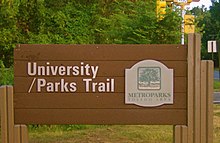
Trail sign on McCord Road. Universityparkstrailsign.jpg
Trail sign on McCord Road.

Five public agencies were involved in the creation of the trail; [4] they are:

See also

Related Research Articles

Toledo, Ohio City in Ohio, United States

Toledo is a city in and the county seat of Lucas County, Ohio, United States. A major Midwestern United States port city, Toledo is the fourth-most-populous city in the U.S. state of Ohio, after Columbus, Cleveland, and Cincinnati, and according to the 2020 census, the 79th-largest city in the United States. With a population of 270,871 it is the principal city of the Toledo metropolitan area. It also serves as a major trade center for the Midwest; its port is the fifth busiest in the Great Lakes and 54th biggest in the United States. The city was founded in 1833 on the west bank of the Maumee River, and originally incorporated as part of Monroe County, Michigan Territory. It was re-founded in 1837, after the conclusion of the Toledo War, when it was incorporated in Ohio.

Sylvania, Ohio City in Ohio, United States

Sylvania is a city in Lucas County, Ohio, United States. The population was 19,011 at the 2020 census. Sylvania is a suburb of Toledo, and encompassed by Sylvania Township. Its northern border is the southern border of the state of Michigan.

Cuyahoga Valley National Park National park in Ohio, United States

Cuyahoga Valley National Park is an American national park that preserves and reclaims the rural landscape along the Cuyahoga River between Akron and Cleveland in Northeast Ohio.

Ohio State Route 184

State Route 184 (SR 184) is a 10.14-mile (16.32 km) long east–west state highway in northwestern Ohio, a U.S. state. The western terminus of SR 184 is at the U.S. Route 23 (US 23) freeway in Sylvania, at a five-ramp parclo AB-3 interchange that also serves as the southern terminus of US 223, as well as the northern terminus of SR 51. The eastern terminus of SR 184 is at a diamond interchange with Interstate 75 in Toledo.

Old Brooklyn Neighborhood of Cleveland in Cuyahoga, Ohio, United States

Old Brooklyn is a west side neighborhood of Cleveland, Ohio, United States, located approximately five miles south of downtown Cleveland. It extends east-to-west from the Cuyahoga River to the city of Brooklyn and north-to-south from the Brookside Park Valley to the city of Parma.

Metroparks Toledo

Metroparks Toledo, officially the Metropolitan Park District of the Toledo Area, is a public park district consisting of parks, nature preserves, a botanical garden, trail network and historic battlefield in Lucas County, Ohio.

Hockhocking Adena Bikeway

The Hockhocking Adena Bikeway is a 21-mile (34 km) long bicycle path in Athens County, Ohio, in the United States. The original section of the path was built on a levee along the Hocking River at Ohio University in Athens, on university land. It was gradually expanded and now crosses university land, city land, and county land. The greater part of the path is a rail trail,. The eastern terminus of the path is near the intersection of East State Street with US-50 on the east side of Athens and its western terminus is in Nelsonville, at the Rocky Brands Factory Outlet at the intersection of Canal Street and Myers Street, one block from the Historic Square Arts District.

Toledo metropolitan area Toledo Metropolitan Area in Ohio, United States

The Toledo Metropolitan Area, or Greater Toledo, is a metropolitan area centered on the American city of Toledo, Ohio. As of the 2010 census, the metropolitan statistical area (MSA) had a population of 651,429. It is the sixth-largest metropolitan area in the state of Ohio, behind Cincinnati–Northern Kentucky, Cleveland, Columbus, Dayton, and Akron.

Cape Cod Rail Trail

The Cape Cod Rail Trail (CCRT) is a 25.5-mile (41.0 km) paved rail trail located on Cape Cod in Massachusetts. The trail route passes through the towns of Yarmouth, Dennis, Harwich, Brewster, Orleans, Eastham, and Wellfleet. It connects to the 6-plus mile (10 km) Old Colony Rail Trail leading to Chatham, the 2 mile Yarmouth multi-use trail, and 8 miles (13 km) of trails within Nickerson State Park. Short side trips on roads lead to national seashore beaches including Coast Guard Beach at the end of the Nauset Bike Trail in Cape Cod National Seashore. The trail is part of the Claire Saltonstall Bikeway.

Wildwood Preserve Metropark

Wildwood Preserve Metropark is a nature reserve and historic estate located in Sylvania Township, Ohio. Wildwood is the most-visited of the 19-park Metroparks Toledo district.

Farnsworth Metropark

Farnsworth Metropark is a regional park in Waterville, Ohio, owned and operated by Metroparks Toledo. The long narrow parks sits on the western shore of the Maumee River with a view of several islands, including Missionary, Butler and Indian islands, all of which are owned by the State of Ohio.

Blue Creek Metropark Conservation area

Blue Creek Metropark is a park and conservation area in Whitehouse and Waterville Township, Ohio, owned by Metroparks Toledo and partially leased to the city of Whitehouse.

Swan Creek Preserve Metropark

Swan Creek Preserve Metropark is a regional park in Toledo, Ohio, owned and managed by Metroparks Toledo. The park contains several miles of often used trails.

Spencer-Sharples Local School District was a small, impoverished district about six miles (10 km) west of Toledo, Ohio. Through a unique act of the Ohio General Assembly, Spencer-Sharples was absorbed into the non-contiguous Toledo Public Schools on Jan. 1, 1968.

Toledo-Lucas County Public Library

Toledo Lucas County Public Library is a public library system located in Toledo, Ohio.

Library Village is one of many historic neighborhoods in Toledo, Ohio; the neighborhood is named for the historic West Toledo Branch Library, located just off Sylvania Avenue at Willys Parkway.

Gwynns Falls Trail

Gywnns Falls Trail is a 15-mile (24 km) series of hiking and bicycling trails inside Baltimore, Maryland, named for the Gwynns Falls, whose course it follows, and the surrounding Gwynns Falls Leakin Park it passes through. The trail uses unique alignments, sidepaths on existing streets, and on-street sections. The trail consists of one 10.75-mile (17.30 km) mainline, plus a number of branches, including the Middle Branch Trail, the Hutton Trail, and the Dickeyville Trail. All of these trails carry signage designating them as the Gwynns Falls Trail; their individual names are designated on the mile markers designating their route. The entirety of the Middle Branch Trail, as well as the section of the mainline trail east of the Middle Branch Trail's northern terminus, are part of the East Coast Greenway.

Wabash Cannonball Trail

The Wabash Cannonball Trail is a rail to trail conversion in northwestern Ohio, U.S. It is 63 miles (101 km) long. The North Fork of the Wabash Cannonball Trail is part of the North Coast Inland Trail, which plans to fully connect Indiana to Pennsylvania, and portions of the trail are included in the North Country National Scenic Trail.

Ohio and Erie Canal Towpath Trail

The Ohio and Erie Canal Towpath Trail is a multi-use trail that follows part of the former route of the Ohio & Erie Canal in Northeast Ohio.

Cleveland Foundation Centennial Lake Link Trail

The Cleveland Foundation Centennial Lake Link Trail, originally known as the Lake Link Trail, is a cycling, hiking, and walking trail located in the city of Cleveland, Ohio, in the United States. Owned by the city of Cleveland and maintained by Cleveland Metroparks, the trail runs along the former track bed of the Cleveland and Mahoning Valley Railroad. The trail is named for The Cleveland Foundation, a local community foundation which donated $5 million toward the trail's construction. The southern leg of the 1.3-mile (2.1 km) trail opened in August 2015, and the northern leg in August 2017. The middle leg will begin construction once the Irishtown Bend hillside is stabilized. A bridge connecting the trail to Whiskey Island will begin construction in Spring 2019 and will be completed in early Summer 2020.

References

  1. "Ohio Wheelchair Accessible Trails". Traillink. Retrieved 3 April 2016.
  2. 1 2 Metroparks of the Toledo Area (2000), University/Parks Trail Brochure, Toledo, Ohio
  3. 1 2 "Toledo, Angola & Western Railway Co". Michigan's Internet Railroad History Museum. Retrieved 4 April 2016.
  4. 1 2 3 The University of Toledo (January 5, 2000), University/Parks Trail, archived from the original on 2007-02-12, retrieved 2007-07-01
  5. "University/Parks Trail extension opens in Sylvania Township". Toledo Blade. Retrieved 15 November 2019.