Varnell, Georgia | |
---|---|
Coordinates: 34°53′58″N84°57′52″W / 34.89944°N 84.96444°W | |
Country | United States |
State | Georgia |
County | Whitfield |
Government | |
• Mayor | Tom Dickson |
Area | |
• Total | 3.83 sq mi (9.92 km2) |
• Land | 3.83 sq mi (9.92 km2) |
• Water | 0.00 sq mi (0.00 km2) |
Elevation | 807 ft (246 m) |
Population (2020) | |
• Total | 2,179 |
• Density | 569.08/sq mi (219.75/km2) |
Time zone | UTC-5 (Eastern (EST)) |
• Summer (DST) | UTC-4 (EDT) |
ZIP code | 30756 |
Area code(s) | 706/762 |
FIPS code | 13-78996 [3] |
GNIS feature ID | 0356614 [2] |
Website | cityofvarnell |
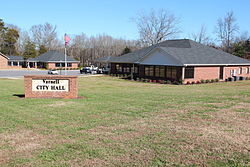
Varnell is a city in Whitfield County, Georgia, United States. It is part of the Dalton, Georgia Metropolitan Statistical Area. The population was 2,179 at the 2020 census. [4]
The Georgia General Assembly incorporated Varnell in 1968. [5] The community was named after M.P. Varnell, a railroad official. [6]
Varnell is located at 34°53′58″N84°57′52″W / 34.89944°N 84.96444°W (34.899367, -84.964573). [7]
According to the United States Census Bureau, the city has a total area of 2.5 square miles (6.5 km2), all land.
Census | Pop. | Note | %± |
---|---|---|---|
1880 | 99 | — | |
1970 | 314 | — | |
1980 | 282 | −10.2% | |
1990 | 358 | 27.0% | |
2000 | 1,491 | 316.5% | |
2010 | 1,744 | 17.0% | |
2020 | 2,179 | 24.9% | |
U.S. Decennial Census [8] 2010 [9] 2020 [10] |
Race / Ethnicity | Pop 2010 [9] | Pop 2020 [10] | % 2010 | % 2020 |
---|---|---|---|---|
White alone (NH) | 1,304 | 1,592 | 74.77% | 73.06% |
Black or African American alone (NH) | 70 | 51 | 4.01% | 2.34% |
Native American or Alaska Native alone (NH) | 6 | 7 | 0.34% | 0.32% |
Asian alone (NH) | 48 | 32 | 2.75% | 1.47% |
Pacific Islander alone (NH) | 0 | 0 | 0.00% | 0.00% |
Some Other Race alone (NH) | 5 | 6 | 0.29% | 0.28% |
Mixed Race/Multi-Racial (NH) | 10 | 58 | 0.57% | 2.66% |
Hispanic or Latino (any race) | 301 | 433 | 17.26% | 19.87% |
Total | 1,744 | 2,179 | 100.00% | 100.00% |
Note: the US Census treats Hispanic/Latino as an ethnic category. This table excludes Latinos from the racial categories and assigns them to a separate category. Hispanics/Latinos can be of any race.
As of the 2010 Census Varnell had a population of 1,744. The racial and ethnic composition of the population was 83.0% white (74.8% non-Hispanic white), 4.3% black or African American, 0.6% Native American, 1.5% Vietnamese, 1.3% other Asian, 8.0% some other race (0.3% non-Hispanic of some other race) and 1.4% from two or more races. 17.3% of the population was Hispanic or Latino, with the largest portion of that being the 14.0% of the population that was Mexican. [11]
As of the census [3] of 2000, there were 1,491 people, 510 households, and 421 families residing in the city. The population density was 606.9 inhabitants per square mile (234.3/km2). There were 526 housing units at an average density of 214.1 units per square mile (82.7 units/km2). The racial makeup of the city was 88.73% White, 4.76% African American, 0.07% Native American, 0.40% Asian, 3.55% from other races, and 2.48% from two or more races. Hispanic or Latino of any race were 5.23% of the population.
There were 510 households, out of which 43.7% had children under the age of 18 living with them, 65.7% were married couples living together, 13.1% had a female householder with no husband present, and 17.3% were non-families. 12.9% of all households were made up of individuals, and 3.3% had someone living alone who was 65 years of age or older. The average household size was 2.92 and the average family size was 3.21.
In the city, the population was spread out, with 30.2% under the age of 18, 9.1% from 18 to 24, 32.9% from 25 to 44, 21.4% from 45 to 64, and 6.4% who were 65 years of age or older. The median age was 32 years. For every 100 females, there were 92.6 males. For every 100 females age 18 and over, there were 90.0 males.
The median income for a household in the city was $46,875, and the median income for a family was $48,674. Males had a median income of $34,000 versus $25,216 for females. The per capita income for the city was $18,214. About 5.8% of families and 6.8% of the population were below the poverty line, including 11.3% of those under age 18 and 15.3% of those age 65 or over.
Varnell is in the Whitfield County School District. [12]
Area schools include: [13]
Clay County is a county located in the southwestern part of the U.S. state of Georgia. As of the 2020 census, the population was 2,848, making it the fourth-least populous county in Georgia. The county seat is Fort Gaines.
Chambers County is a county located in the east central portion of the U.S. state of Alabama. As of the 2020 census the population was 34,772. Its county seat is LaFayette. Its largest city is Valley. Its name is in honor of Henry H. Chambers, who served as a United States Senator from Alabama.
Cleburne County is a county located in the east central portion of the U.S. state of Alabama. As of the 2020 census, the population was 15,056. Its county seat is Heflin. Its name is in honor of Patrick R. Cleburne of Arkansas who rose to the rank of major general in the Confederate States Army. The eastern side of the county borders the state of Georgia.
Houston County is a county located in the southeastern corner of the U.S. state of Alabama. As of the 2020 census the population was 107,202. Its county seat is Dothan, which is located on the border and partially in adjacent Henry County.
Whitfield County is a county located in the northwestern part of the U.S. state of Georgia. As of the 2020 census shows a population of 102,864. The county seat is Dalton. The county was created on December 30, 1851, and named after George Whitefield, Methodist evangelist. The "e" was omitted to reflect the pronunciation of his name.
Walker County is a county located in the northwestern part of the U.S. state of Georgia. As of the 2020 census, the population was 67,654, down from 68,756 in 2010. The county seat is LaFayette. The county was created on December 18, 1833, from land formerly belonging to the Cherokee Indian Nation. Walker County is part of the Chattanooga TN/GA Metropolitan Statistical Area.
Murray County is a county located in the northwestern part of the U.S. state of Georgia. As of the 2020 census, the population was 39,973. The county seat is Chatsworth.
Catoosa County is a county located in the northwestern part of the U.S. state of Georgia. According to the 2020 census, the population was 67,872. The county seat is Ringgold. The county was created on December 5, 1853. The meaning of the Cherokee language name "Catoosa" is obscure. "Catoosa" may come from the Cherokee words gatusi or gatu'gitse.
Barrow County is a county located in the north central portion of the U.S. state of Georgia. As of the 2020 census, its population was 83,505. Its county seat is Winder. Barrow County is included in the Atlanta–Sandy Springs–Roswell metropolitan statistical area.
Leisure City is an unincorporated community and census-designated place (CDP) in Miami-Dade County, Florida, United States, that includes the smaller, older community of Modello in its northwestern section. The CDP is most notable for the Coral Castle Museum, located in the Modello area. It is located in the Miami metropolitan area of South Florida. The population was 26,324 at the 2020 census, up from 22,655 in 2010.
Emerson is a city in far southern Bartow County, Georgia, United States, on highways US-41/GA-3, GA-293, and I-75. The population was 1,470 at the 2010 census, an increase of 34% over the 2000 count of 1,092.
Payne, more commonly known as Payne City, was a city in Bibb County, Georgia, United States. Payne was an enclave completely surrounded by the city of Macon, and was the only other incorporated area in the county. The population was 218 at the 2010 census.
Vinings is an unincorporated community and census-designated place (CDP) in Cobb County, Georgia, United States that runs along the Chattahoochee River bank across from Buckhead. As of the 2020 census, the CDP had a total population of 12,581. Located next to the affluent Paces section of Buckhead in northwest Atlanta, Vinings is known for its historic sites, shopping districts, proximity to local freeways and The Battery, and nearby nature areas. The United States Postal Service assigns "Atlanta" to the ZIP Code (30339) that includes Vinings.
Blue Ridge is a city in Fannin County, Georgia, United States. As of the 2020 census, the city had a population of 1,253. The city is the county seat of Fannin County and the largest city in the county.
Union Point is a city in Greene County, Georgia, United States. As of the 2020 census, the city population was 1,597.
Tunnel Hill is a city in northwest Whitfield County and southern Catoosa County, Georgia, United States. It is part of the Dalton Metropolitan Statistical Area. The population was 963 at the 2020 census. The city is named for the Chetoogeta Mountain Tunnel, a 1,497-foot (456 m) railroad tunnel built in the late 1840s.
Cool Valley is a city in St. Louis County, Missouri, United States in Greater St. Louis. The population was 1,196 at the 2010 census.
Anton is a city in Hockley County, Texas, United States. The population was 907 at the 2020 census.
San Diego is a city in Duval and Jim Wells counties, Texas, United States. The population was 3,748 at the 2020 census and 4,488 at the 2010 census. It is located primarily in Duval County, of which it is the county seat.
The Dalton Metropolitan Statistical Area, as defined by the United States Census Bureau, is an area consisting of two counties in northwestern Georgia, anchored by the city of Dalton. At the 2020 census, the MSA had a population of 142,837. The MSA is included in the Chattanooga–Cleveland–Dalton, TN–GA–AL Combined Statistical Area