Vasto

Last updated • 6 min readFrom Wikipedia, The Free Encyclopedia
Vasto
Città del Vasto
Il Faro di Punta Penna-2007.jpg
Lighthouse of Punta Penna, the second tallest in Italy and seventh tallest in the world
Flag of Vasto.svg
Vasto-Stemma-3.svg
Location of Vasto
Vasto
Italy provincial location map 2016.svg
Red pog.svg
Vasto
Location of Vasto in Italy
Italy Abruzzo location map.svg
Red pog.svg
Vasto
Vasto (Abruzzo)
Coordinates: 42°07′00″N14°42′25″E / 42.11667°N 14.70694°E / 42.11667; 14.70694
Country Italy
Region Abruzzo
Province Chieti (CH)
Government
  MayorFrancesco Menna (Partito Democratico)
Area
[1]
  Total
70.65 km2 (27.28 sq mi)
Elevation
138 m (453 ft)
Population
 (January 1, 2023) [2]
  Total
40,692
  Density580/km2 (1,500/sq mi)
Demonym Vastesi
Time zone UTC+1 (CET)
  Summer (DST) UTC+2 (CEST)
Postal code
66054
Dialing code 0873
Patron saint Saint Michael
Saint daySeptember 29
Website Official website

Vasto (Abruzzese: lù Uàštë; Ancient Greek : Ἱστόνιον, romanized: Histonion, Latin : Histonium) is a comune on the Adriatic coast of the Province of Chieti, in southern Abruzzo, Italy. During the Middle Ages it was called Guastaymonis, Vasto d'Aimone or Waste d'Aimone. [3] Fascist Italy called the city Istonio, but it was renamed Vasto in 1944.

Contents

History

Ancient period

According to legend, the town was founded by Diomedes, the Greek hero. The earliest archaeological relics date to 1300 BC. Histonium was one of the key towns of the Frentani, located on the Adriatic coast, about 9 kilometres (6 mi) south of the promontory called Punta Penna.

Ancient geographers cited the town as located in the territory of the Frentani and apparently under Julius Caesar [4] did not obtain the rank of a colonia, but continued to bear the title of a municipium, as we learn from some inscriptions. [5] Under the Roman Empire, the municipium of Histonium was a flourishing and opulent town, further attested by the existing ruins of an ancient Roman theatre, baths, and other public edifices, besides numerous mosaics, statues, and columns of granite or marble. [6]

Among the numerous inscriptions which have been found, one of the most curious records the fact of a young boy named Lucius Valerius Pudens having at thirteen years of age won the prize for Latin poetry in the contest held at Rome in the temple of Jupiter Capitolinus. [7] The name of Histonium is still found in the Itineraries of the fourth century [8] and it probably never ceased to exist on its present site, though ravaged successively by the Goths, the Lombards, the Franks, and the Arabs.

Castello Caldoresco in Piazza Rossetti Vasto piazza Rossetti.jpg
Castello Caldoresco in Piazza Rossetti

Histonium had no natural port, and it is not improbable that in the days of its prosperity it depended on the port at the Punta Penna, where the current harbour that is the Porto di Vasto  [ it ] and the lighthouse are located, where there is good anchorage, and where Roman remains have also been found, which have been regarded, but probably erroneously, as those of the settlement of Buca. [9]

Middle Ages

Cathedral of San Giuseppe Cattedrale di San Giuseppe a Vasto.JPG
Cathedral of San Giuseppe
Palazzo d'Avalos Vasto 2011-08 by-RaBoe-018.jpg
Palazzo d'Avalos

After the collapse of the Western Roman Empire, the region was occupied by Germanic tribes until Justinian's Byzantine re-conquest, which included the province of Samnium, of which Histonium was a key town. However soon after Justinian's death, Histonium fell to the Lombards and incorporated into the Duchy of Benevento. Later, circa 774 AD, the town was conquered by the Franks. Subsequently, in 1053, the Normans under Robert Guiscard in turn captured it along with the Duchy of Benevento. Around 1076, Histonium was renamed Guastaymonis, or the Waste of Aimone (Italian : Il Guasto d'Aimone), following raids, hence its current name. From the 13th century it was part of the Kingdom of Naples, which later merged into the Kingdom of the Two Sicilies.

In the 15th century the city's urban structure was transformed by the condottiero Giacomo Caldora, who had become its lord. The Caldora family built new city walls still seen today, including the Torre Bassano tower in Piazza Rossetti, the Torre Diomede in Vico Storto del Passero, the Torre Diamante in Piazza Verdi and Porta Catena, and with Castello Caldoresco as its primary defensive outpost.

In 1566, Turkish Ottoman naval forces, led by Piyale Pasha, destroyed much of the city by fire, including the Castello Caldoresco, the Church of Santa Margherita and the Palazzo d'Avalos (formerly a home of Vittoria Colonna – close confidante of Michelangelo – now the Musei di Palazzo d'Avalos).

From Spanish rule until Italy's Unification

Under the Spanish rule of southern Italy, Vasto became fief of the Marquis d'Avalos, and under the reign of Cesare Michelangelo (marquis from 1697 to 1729), Vasto reached its zenith. Only superficially shaken by revolutionary events in 1799 (a short-lived Republic of Vasto was immediately overthrown by the sanfedista, or loyalists), the city's history was reflected in the nation's throughout the Restoration to the Unity of Italy when a liberal elite governed.

The poet and scholar Gabriele Rossetti was born in Vasto on 28 February 1783. Rossetti's published works include literary criticism, Romantic poetry such as his long poem Il Veggente in Solitudine of 1846, and his autobiography. Gabriele went into political exile in 1821, settling in London, England.

He was the father of well-known pre-Raphaelite painter Dante Gabriel Rossetti and poet Christina Rossetti. Gabriele died on 24 April 1854 and is buried in London's Highgate Cemetery with his wife Frances Polidori.

Modern

In the early 20th century, Vasto changed its architectural and urban features. The historical centre was redrawn and the foundations were set for drastic alterations during the 1920s and 1930s, with Mussolini decreeing a name change to Istonio in 1938, the official name until the liberation of the city from the Allied Forces in 1944.

Despite a devastating landslide (1956) that dragged a significant part of the eastern ridge – now Via Adriatica – into the gorge below, the years following World War II witnessed industrial, urban, and socio-cultural development. The city also discovered its tourist vocation: besides the progressive development of its beaches in Marina di Vasto, Roman-era thermal baths, mosaics, cisterns and remains of an amphitheatre were found and restored.

During the 1970s until the recent days, the town underwent a remarkable change and a fast growth, with several housing, road and other infrastructure projects built to accommodate the emigrating population from the inner areas of Southern Abruzzo, which have made it one of the most populous of the region.

Main sights

Santa Maria Maggiore Chiesa di Santa Maria Maggiore, Vasto 2.JPG
Santa Maria Maggiore

The old part of the town (centro storico) features a number of buildings and churches dating from the 12th-18th centuries, including:

Below the hill on which the town is located, the beach resort town of Marina di Vasto offers a large sandy beach and several hotels and other facilities.

Marina di Vasto and the Golfo di Vasto in the Adriatic Sea, seen from Vasto Vasto Marina, Vasto.jpg
Marina di Vasto and the Golfo di Vasto in the Adriatic Sea, seen from Vasto

Further north the coast becomes rocky and features interesting pebble and stone beaches and coves, as well as the typical trabocchi, typical wooden fishing machines of the Southern Abruzzo coast. Amongst the natural areas, also featuring a number of sandy and rocky beaches, is the protected natural area of the Riserva Naturale di Punta Aderci, whose beaches were voted in 2014 third of the top 20 beaches in Italy. [11]

Trabocco Trabocco, localita' Canale, Vasto.jpg
Trabocco

Notable people from Vasto

Climate

Climate data for Vasto (1991–2020 normals, extremes 1951–2000)
MonthJanFebMarAprMayJunJulAugSepOctNovDecYear
Record high °C (°F)23.0
(73.4)
24.5
(76.1)
28.0
(82.4)
29.1
(84.4)
34.8
(94.6)
38.4
(101.1)
40.2
(104.4)
42.5
(108.5)
38.5
(101.3)
33.2
(91.8)
27.2
(81.0)
24.3
(75.7)
42.5
(108.5)
Mean daily maximum °C (°F)10.5
(50.9)
11.0
(51.8)
13.9
(57.0)
17.3
(63.1)
21.6
(70.9)
25.9
(78.6)
28.5
(83.3)
28.7
(83.7)
24.3
(75.7)
20.0
(68.0)
15.6
(60.1)
11.7
(53.1)
19.1
(66.4)
Daily mean °C (°F)7.7
(45.9)
8.0
(46.4)
10.6
(51.1)
13.8
(56.8)
17.9
(64.2)
22.1
(71.8)
24.7
(76.5)
24.9
(76.8)
20.7
(69.3)
16.8
(62.2)
12.7
(54.9)
8.9
(48.0)
15.7
(60.3)
Mean daily minimum °C (°F)4.9
(40.8)
5.0
(41.0)
7.2
(45.0)
10.2
(50.4)
14.2
(57.6)
18.4
(65.1)
21.0
(69.8)
21.1
(70.0)
17.1
(62.8)
13.6
(56.5)
9.7
(49.5)
6.2
(43.2)
12.4
(54.3)
Record low °C (°F)−6.4
(20.5)
−6.8
(19.8)
−5.0
(23.0)
0.9
(33.6)
2.5
(36.5)
9.3
(48.7)
12.0
(53.6)
10.0
(50.0)
8.0
(46.4)
4.0
(39.2)
−8.0
(17.6)
−3.8
(25.2)
−8.0
(17.6)
Average precipitation mm (inches)63.3
(2.49)
53.0
(2.09)
59.7
(2.35)
51.2
(2.02)
36.8
(1.45)
33.0
(1.30)
35.2
(1.39)
42.2
(1.66)
63.0
(2.48)
75.0
(2.95)
81.4
(3.20)
87.1
(3.43)
680.9
(26.81)
Average precipitation days7.16.26.85.54.83.73.33.74.96.67.87.768.1
Source 1: Istituto Superiore per la Protezione e la Ricerca Ambientale [12]
Source 2: Regione Abruzzo (precipitation and extremes 1951–2000) [13]

Twinnings

See also

Related Research Articles

<span class="mw-page-title-main">Province of Chieti</span> Province of Italy

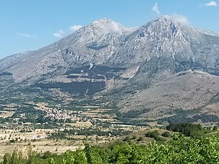
The province of Chieti is a province in the Abruzzo region of Italy. Its provincial capital is the city Chieti, which has a population of 50,770 inhabitants. The province has a total population of 387,649 inhabitants as of 2017 and spans an area of 2,599.58 square kilometres (1,003.70 sq mi). The province contains 104 comuni. Its provincial president is Mario Pupillo.

<span class="mw-page-title-main">Ortona</span> Comune in Abruzzo, Italy

Ortona is a coastal town and municipality of the Province of Chieti in the Italian region of Abruzzo, with some 23,000 inhabitants.

<span class="mw-page-title-main">Sulmona</span> Comune in Abruzzo, Italy

Sulmona is a comune (municipality) in the province of L'Aquila, in the Italian region of Abruzzo. It is located in the Valle Peligna, a plain once occupied by a lake that disappeared in prehistoric times. In the ancient era, it was one of the most important cities of the Paeligni and is known for being the native town of the Roman poet Ovid, of whom there is a bronze statue, located on the town's main road.

<span class="mw-page-title-main">Lanciano</span> Comune in Abruzzo, Italy

Lanciano is a town and comune in the province of Chieti, part of the Abruzzo region of central Italy. It has 33,944 inhabitants as of 2023. The town is known for the first recorded Catholic Eucharistic Miracle. Lanciano is located about 10 kilometres (6.2 mi) from the Adriatic Sea in an elevated spot.

<span class="mw-page-title-main">Carsoli</span> Comune in Abruzzo, Italy

Carsoli is a town and comune in the province of L'Aquila, Abruzzo. The ancient Roman city lies 4 kilometres (2.5 mi) southwest of the modern town.

<span class="mw-page-title-main">Frentani</span>

The Frentani were an Italic tribe occupying the tract on the southeast coast of the Italian peninsula from the Apennines to the Adriatic, and from the frontiers of Apulia to those of the Marrucini. They were bounded on the west by the Samnites, with whom they were closely connected, and from whom they were originally descended. Hence Scylax assigns the whole of this line of coast, from the frontiers of Apulia to those of Picenum, to the Samnites. Their exact limits are less clearly defined, and there is considerable discrepancy in the statements of ancient geographers: Larinum, with its territory, being by some writers termed a city of the Frentani, while the more general opinion included it in Apulia, and thus made the river Tifernus the limit of the two countries. The northern boundary of the Frentani is equally uncertain; both Strabo and Ptolemy concur in fixing it at the river Sagrus, while Pliny extends their limits as far as the Aternus, and, according to Mela, they possessed the mouths both of that river and the Matrinus. The latter statement is certainly inaccurate; and Strabo distinctly tells us that the Marrucini held the right bank of the Aternus down to its mouth, while the Vestini possessed the left bank; hence, the former people must have intervened between the Frentani and the mouth of the Aternus. Pliny's account is, however, nearer the truth than that of Strabo and Ptolemy; for it is certain that Ortona and Anxanum, both of which are situated considerably to the north of the Sagrus, were Frentanian cities. The latter is indeed assigned by Ptolemy to that people, while Strabo also terms Ortona the port or naval station of the Frentani, but erroneously places it to the south of the river Sagrus. Hence, their confines must have approached within a few miles of the Aternus, though without actually abutting upon that river. On the west, they were probably not separated from the Samnites by any well-marked natural boundary, but occupied the lower slopes of the Apennines as well as the hilly country extending from thence to the sea, while the more lofty and central ridges of the mountains were included in Samnium.

<span class="mw-page-title-main">Giulianova</span> Comune in Abruzzo, Italy

Giulianova is a coastal town and comune in the province of Teramo, Abruzzo region, Italy. The comune also has city status, thus also known as Città di Giulianova.

<span class="mw-page-title-main">Troia, Apulia</span> Comune in Apulia, Italy

Troia is a town and comune in the province of Foggia and region of Apulia in southern Italy.

<span class="mw-page-title-main">Palmoli</span> Comune in Abruzzo, Italy

Palmoli is a comune and town in the province of Chieti, Abruzzo, south-eastern Italy.

<span class="mw-page-title-main">Scerni</span> Comune in Abruzzo, Italy

Scerni is a town of 3,645 inhabitants of the province of Chieti is part of the Middle Vastese. Total area is 41 square kilometres (16 sq mi), and population density is 89 inhab/km2. The county has borders with Atessa, Gissi, Monteodorisio and Pollutri.

<span class="mw-page-title-main">Montazzoli</span> Comune in Abruzzo, Italy

Montazzoli is a comune and town in the Province of Chieti in the Abruzzo region of Italy

<span class="mw-page-title-main">Massa d'Albe</span> Comune in Abruzzo, Italy

Massa d'Albe is a comune and town in the province of L'Aquila in the Abruzzo region of central Italy. It is part of the Marsica.

Pescocostanzo is a comune and town of 1038 inhabitants in the Province of L'Aquila in the Abruzzo region of Italy. It is a tourist destination, attracting people from all over Italy due to its landscape and environment. It is part of the Maiella National Park and is one of I Borghi più belli d'Italia. In winter, Pescocostanzo is a destination for skiers and snowboarders, and has its own ski resort. The towns of Roccaraso and Rivisondoli are close by.

<span class="mw-page-title-main">San Benedetto dei Marsi</span> Comune in Abruzzo, Italy

San Benedetto dei Marsi is a comune and town in the province of L'Aquila in the Abruzzo region of central Italy. It is on the eastern shore of the dried Lake Fucino, 20 kilometres (12 mi) from the remains of another ancient site, Alba Fucens.

<span class="mw-page-title-main">Scurcola Marsicana</span> Comune in Abruzzo, Italy

Scurcola Marsicana is a comune and town in the province of L'Aquila, in the Abruzzo region of central Italy.

<span class="mw-page-title-main">Atri, Abruzzo</span> Comune in Abruzzo, Italy

Atri is a comune in the Province of Teramo in the Abruzzo region of Italy. Atri is the setting of the poem The Bell of Atri by American writer Henry Wadsworth Longfellow. Its name is the origin of the name of the Emperor Hadrian, whose family came from the town.

<span class="mw-page-title-main">Tourism in Abruzzo</span> Tourism in Abruzzo, Italy

Tourism in Abruzzo has become one of the most prosperous sectors in the economy of Abruzzo, and in recent years has seen a remarkable growth attracting numerous tourists from Italy and Europe. According to statistics, in 2021 arrivals totaled 1,330,887. A total of 5,197,765 arrivals were tourists, a figure that puts the region seventeenth among the Italian regions for numbers of tourists per year. A moderate support to tourism is also given to the Abruzzo Airport with many low cost and charter flights connecting the entire region with the rest of Europe.

<span class="mw-page-title-main">Trabocchi Coast</span> Place in Abruzzo, Italy

The Trabocchi Coast, which corresponds to the coastal stretch Adriatic of province of Chieti (Abruzzo), is a 70-kilometer coast from Ortona to San Salvo, in Italy. It comprises a number of coves and reefs below the hills that end at the Adriatic Sea marked by the spread of Trabucco – fishing machines on piles. Many of the towns on the Coast maintain their own characteristics and traditions.

<span class="mw-page-title-main">Castello Caldoresco</span> Castello Caldoresco Italy

Castello Caldoresco is a Renaissance castle in Vasto, Province of Chieti, Abruzzo, south-eastern Italy. It is a private property and therefore is not open to the public.

<span class="mw-page-title-main">Palazzo D'Avalos</span>

The Palazzo D'Avalos is a monumental palace located on Piazza Lucio Pudente, in the historic center of Vasto, region of Marche, Italy. Until 1806, the residence of the Marquises of Vasto, it now houses three civic museums: theArchaeological Museum, the Pinacoteca, and the Costume Museum.

References

  1. "Superficie di Comuni Province e Regioni italiane al 9 ottobre 2011". Italian National Institute of Statistics. Retrieved 16 March 2019.
  2. citypopulation.de. "Abruzzo Region".
  3. Abruzzo – Bradt Guide, 2nd Edition, 2013, page 268
  4. (Mela ii. 4. § 9; Pliny the Elder iii. 12. s. 17; Ptolemy iii. 1. § 18; Lib. Colon. p. 260; August Wilhelm Zumpt, De Coloniis p. 307.
  5. Orell. Inscr. 2603, 4052; Zumpt, l. c..
  6. Romanelli, vol. iii. p. 32.
  7. Romanelli, l. c. p. 34; Orell. Inscr. 2603; Mommsen, I. R. N. 5252.)
  8. Antonine Itinerary p. 314; Tabula Peutingeriana.
  9. Mommsen, lnscr. Regn. Neap. p. 274, App. p. 30; who has collected and published all the genuine inscriptions found at Histonium.
  10. Chiese di Vasto: Santa Maria Maggiore, 2014, at the URL:
  11. Legambiente, 2014 http://www.legambiente.it/contenuti/comunicati/le-spiagge-piu-belle-dell-estate-2014-cala-degli-infreschi-camerota-e-la-piu-ap
  12. "Valori climatici normali in Italia". Istituto Superiore per la Protezione e la Ricerca Ambientale. Archived from the original on 17 September 2023. Retrieved 29 June 2024.
  13. "VALORI MEDI CLIMATICI DAL 1951 AL 2000 NELLA REGIONE ABRUZZO" (PDF). Regione Abruzzo. Archived from the original (PDF) on 30 June 2024. Retrieved 30 June 2024.

PD-icon.svg This article incorporates text from a publication now in the public domain :  Smith, William, ed. (1854–1857). "Histonium". Dictionary of Greek and Roman Geography . London: John Murray.