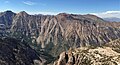
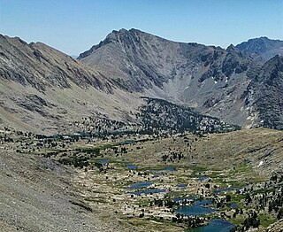
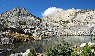
Picture Puzzle, also known as Picture Puzzle Peak, is a 13,297-foot-elevation mountain summit located one mile east of the crest of the Sierra Nevada mountain range in Inyo County of northern California, United States. It is situated in the Palisades area of the John Muir Wilderness, on land managed by Inyo National Forest. It is approximately 14.5 miles (23.3 km) west of the community of Big Pine, one mile north of Bishop Pass, 0.8 miles (1.3 km) northwest of Aperture Peak, 1.2 miles (1.9 km) north-northwest of Mount Agassiz, and 1.1 miles (1.8 km) south-southwest of parent Cloudripper. Picture Puzzle ranks as the 90th-highest summit in California, and the third-highest peak of the Inconsolable Range.

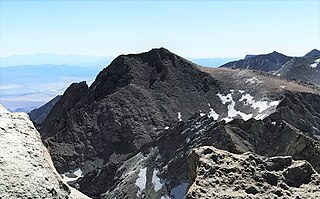
Picture Peak is a 13,140+ foot mountain summit located one mile east of the crest of the Sierra Nevada mountain range in Inyo County in northern California, United States. It is situated in the John Muir Wilderness, on land managed by Inyo National Forest. It is approximately 21 miles (34 km) west of the community of Big Pine, and 0.65 miles (1.05 km) east of parent Mount Haeckel. Topographic relief is significant as the north aspect rises over 2,000 feet above Hungry Packer Lake in approximately one-half mile (1 km). The first ascent of the summit was made July 1967, by Gary Colliver and Steve Thompson via the northeast face. This mountain's name has not been officially adopted by the U.S. Board on Geographic Names.

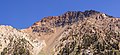
Black Mountain is a 13,291-foot-elevation (4,051-meter) mountain summit located on the crest of the Sierra Nevada mountain range in northern California. It is situated on the common border of Fresno County with Inyo County, as well as the shared boundary of John Muir Wilderness and Kings Canyon National Park. It is 10.5 miles (16.9 km) west of the community of Independence, and 4.3 miles (6.9 km) north-northwest of parent University Peak. Black Mountain ranks as the 91st highest summit in California. Topographic relief is significant as the west aspect rises 2,750 feet above Rae Lakes in approximately one mile. The John Muir Trail traverses below the west aspect of this peak, providing an approach to the mountain. The first ascent of the summit was made in 1905 by George R. Davis, a USGS topographer. This mountain is habitat for the endangered Sierra Nevada bighorn sheep, which restricts climbing from July through December, so most ascents are made in the spring.

Crater Mountain is a 12,874-foot-elevation (3,924-meter) mountain summit located west of the crest of the Sierra Nevada mountain range, in Fresno County of northern California, United States. It is situated in eastern Kings Canyon National Park, 15.5 miles (24.9 km) northwest of the community of Independence, one mile immediately southwest of Pinchot Pass, and 1.3 miles (2.1 km) southeast of Mount Ickes, which is the nearest higher neighbor. Other nearby peaks include Mount Wynne, 1.5 miles (2.4 km) to the northeast, and Mount Cedric Wright, 2.2 miles (3.5 km) to the southeast. Crater Mountain ranks as the 186th highest summit in California. Topographic relief is significant as the west aspect rises 2,000 feet in less than one mile. The approach to this remote peak is made via the John Muir Trail which passes below the east aspect of the mountain. The first ascent of the summit was made July 19, 1922, by W. H. Ink, Meyers Butte, Frank Baxter, and Captain Wallace. This mountain has no crater as the name implies.
Colosseum Mountain is a 12,473-foot-elevation double summit mountain located on the crest of the Sierra Nevada mountain range in northern California. It is situated on the common border of Fresno County with Inyo County, as well as the shared boundary of John Muir Wilderness and Kings Canyon National Park. It is 12 miles (19 km) northwest of the community of Independence, 1.2 miles (1.9 km) east of Mount Cedric Wright, 2.6 miles (4.2 km) west of Sawmill Point, and 1.6 miles (2.6 km) south-southeast of Mount Perkins, the nearest higher neighbor. The lower east summit is 12,451-feet in elevation and marked as Colosseum Mountain on maps, but the 12,473-foot west summit is higher. Approximately 1,000 feet distance separate the two summits. The John Muir Trail passes to the west of this peak, providing an approach to the mountain. The first ascent of the summit was made August 5, 1922, by Chester Versteeg, a prominent Sierra Club member, via the southwest face.

Crown Point is a mountain with a summit elevation of 11,346 feet (3,458 m) located in the Sierra Nevada mountain range, in Mono County of northern California, United States. The summit is set in the Hoover Wilderness on land managed by Humboldt–Toiyabe National Forest, whereas the lower southwest slope is set within Yosemite National Park and Tuolumne County. The peak is situated approximately five miles southwest of Twin Lakes, one mile southeast of Peeler Lake, three miles southeast of Kettle Peak, and 4.3 miles (6.9 km) west-northwest of Matterhorn Peak. Topographic relief is significant as the northeast aspect rises over 2,100 feet above the Robinson Lakes in one mile. The first ascent of the summit was made in 1905 by George R. Davis, Albert Hale Sylvester, and Pearson Chapman, all with the United States Geological Survey.

Cirque Peak is a 12,900-foot-elevation (3,900-meter) mountain summit located on the crest of the Sierra Nevada mountain range in California. It is situated on the common border of Tulare County with Inyo County, as well as the shared boundary of Golden Trout Wilderness and John Muir Wilderness, on land managed by Inyo National Forest. It is 14 miles (23 km) southwest of the community of Lone Pine, 7.7 miles (12.4 km) south-southeast of Mount Whitney, and 3.2 miles (5.1 km) south of Mount Langley, the nearest higher neighbor. Cirque Peak is the highest point of the Golden Trout Wilderness, and ranks as the 175th highest peak in California. Topographic relief is significant as it rises 1,800 feet above Cirque Lake in approximately one mile. The Pacific Crest Trail traverses the southwest slope of this mountain, providing an approach option. The mountain was apparently named in 1890 by Joseph Nisbet LeConte and companions who noted the remarkable cirque on the north aspect.
Trojan Peak is a 13,947-foot-elevation (4,251-meter) mountain summit located along the crest of the Sierra Nevada mountain range in Inyo County, California. It is situated in the John Muir Wilderness, on land managed by Inyo National Forest. It is 15 miles (24 km) west-northwest of the community of Lone Pine, 0.7 miles (1.1 km) southeast of Mount Versteeg, and one mile (1.6 km) south-southwest of Mount Williamson, the nearest higher neighbor. Trojan Peak is ranked as the 16th highest peak in California. Topographic relief is significant as it rises 1,427 feet above Lake Helen of Troy in approximately one-half mile.

Kettle Peak is a mountain with a summit elevation of 11,010 feet (3,356 m) located in the Sierra Nevada mountain range, in Mono County of northern California, United States. The summit is set in the Hoover Wilderness on land managed by Humboldt–Toiyabe National Forest, and is less than one-half mile outside the boundary of Yosemite National Park. The peak is situated approximately three miles southwest of Twin Lakes, three miles south of Victoria Peak, 2.9 miles northeast of Crown Point, and 3.1 miles northwest of Matterhorn Peak. Topographic relief is significant as the west aspect rises over 2,600 feet above Robinson Creek in one mile.

Hunewill Peak is a mountain with a summit elevation of 11,713 feet (3,570 m) located in the Sierra Nevada mountain range, in Mono County of northern California, United States. The summit is set in Hoover Wilderness on land managed by Humboldt–Toiyabe National Forest. The peak is situated approximately four miles west of Twin Lakes, 1.3 mile southwest of Victoria Peak, and 2.4 miles southwest of line parent Eagle Peak. Precipitation runoff from this mountain drains into tributaries of Robinson and Buckeye Creeks, which are within the Walker River drainage basin. Topographic relief is significant as the summit rises over 3,500 feet above Robinson Creek in approximately one mile (1.6 km).
The Incredible Hulk, or Incredible Hulk, is a granitic summit with an elevation of 11,300 feet (3,444 m) located in the Sierra Nevada mountain range, in Mono County of northern California, United States. The summit is set in Little Slide Canyon of the Hoover Wilderness, on land managed by Humboldt–Toiyabe National Forest, and is one mile outside the boundary of Yosemite National Park. The peak is situated approximately three miles southwest of Twin Lakes, three-quarters mile east of Kettle Peak, and 2.5 miles northwest of Matterhorn Peak. The nearest town is Bridgeport, 14 miles to the northeast. Topographic relief is significant as the summit rises 3,700 feet above Robinson Creek in one mile (1.6 km). Incredible Hulk is the unofficial name of this landform, and will remain unofficial as long as the USGS policy of not adopting new toponyms in designated wilderness areas remains in effect.

Stanton Peak is a granitic mountain with a summit elevation of 11,695 feet (3,565 m) located in the Sierra Nevada mountain range, in Tuolumne County of northern California, United States. The remote summit is set within Yosemite National Park, and is situated 0.63 mile southwest of line parent Virginia Peak, 1.6 mile southeast of Whorl Mountain, and 2.6 miles south-southeast of Matterhorn Peak. Stanton Peak is bound on the west by Spiller Creek and on the east by Return Creek, so precipitation runoff from this mountain drains into these two tributaries of the Tuolumne River. Topographic relief is significant as the summit rises over 2,100 feet above Spiller Creek in one mile.

Mount Starr, elevation 12,835 feet (3,912 m), is a mountain summit located on the crest of the Sierra Nevada mountain range in northern California, United States. It is situated in the John Muir Wilderness on the common boundary shared by Sierra National Forest with Inyo National Forest, and along the common border of Fresno County with Inyo County. It is bound on the east by Little Lakes Valley, and is 0.8 mile northeast of Mono Pass. Topographic relief is significant as the summit rises 2,300 feet above Little Lakes Valley in approximately one-half mile (0.80 km). Neighbors include Mount Abbot, three miles to the south-southwest, Mount Morgan, 2.5 miles to the southeast, and Pointless Peak is 2.5 miles to the north.

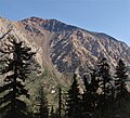
Four Gables, elevation 12,776 feet (3,894 m), is a mountain summit located on the crest of the Sierra Nevada mountain range in northern California, United States. It is situated in the John Muir Wilderness on the common boundary shared by Sierra National Forest with Inyo National Forest, and along the common border of Fresno County with Inyo County. Topographic relief is significant as the summit rises 2,800 feet above Horton Lake in approximately 1.5 miles (2.4 km). Neighbors include Basin Mountain, two miles to the east-southeast, Mount Tom, three miles to the northeast, and Merriam Peak, four miles to the west. The nearest community is Bishop, California, 17 miles to the east.
Eocene Peak is a granitic summit with an elevation of 11,569 feet (3,526 m) located on the crest of the Sierra Nevada mountain range, in northern California, United States. The summit is situated on the common boundary shared by Yosemite National Park with Hoover Wilderness, as well as the common border of Mono County and Tuolumne County. The peak is set approximately three miles southwest of Twin Lakes, 1.3 mile southeast of Kettle Peak, and one mile south of The Incredible Hulk. The nearest town is Bridgeport, 15 miles to the northeast. Topographic relief is significant as the summit rises nearly 2,000 feet above Piute Creek in one mile. The first ascent of the summit was made July 16, 1932, by Richard M. Leonard and Herbert B. Blanks. This landform's name has not been officially adopted by the U.S. Board on Geographic Names, so the feature is not labeled on USGS maps.
Graveyard Peak is an 11,539-foot-elevation (3,517 meter) mountain summit located in the Sierra Nevada mountain range in Fresno County of northern California, United States. It is situated in the John Muir Wilderness, on land managed by Sierra National Forest. Graveyard Peak ranks as the 535th-highest summit in California, and topographic relief is significant as the south aspect rises over 2,300 feet above Devils Bathtub in approximately one mile. It is two miles southeast of Silver Peak, five miles north of Lake Thomas A Edison, and approximately 13 miles (21 km) south of the community of Mammoth Lakes. The peak is set on Silver Divide, so precipitation runoff from the north side of this mountain drains into Fish Creek which is a tributary of the San Joaquin River, and from the south slope to Lake Thomas A Edison. The peak is most easily reached out of Lake Thomas Edison.

Picket Guard Peak is a 12,302-foot-elevation (3,750 meter) mountain summit located west of the crest of the Sierra Nevada mountain range in Tulare County, California. It is situated in Sequoia National Park, two miles southwest of Kern Point, 3.4 miles (5.5 km) north of Mount Kaweah, and three miles east of the junction of Kaweah Peaks Ridge with Great Western Divide. Picket Guard Peak ranks as the 345th-highest summit in California, and topographic relief is significant as the summit rises 4,265 feet above Kern Canyon in approximately three miles.

Robinson Peak is a mountain with an elevation of 10,793 feet (3,290 m) located in the Sierra Nevada mountain range, in Mono County of northern California, United States. The summit is situated on the boundary of Hoover Wilderness, on land managed by Humboldt–Toiyabe National Forest. The peak is set above the west end of Twin Lakes, two miles east of Victoria Peak, and 1.5 mile southeast of line parent Eagle Peak. Precipitation runoff from this mountain drains into tributaries of Robinson and Buckeye Creeks, which are within the Walker River drainage basin. Topographic relief is significant as the summit rises approximately 3,700 feet above Robinson Creek in 1.5 mile.
Hawksbeak Peak is a mountain summit with an elevation of 11,134 feet (3,394 m) located on the crest of the Sierra Nevada mountain range, in northern California, United States. The granitic summit is situated on the common boundary shared by Yosemite National Park with Hoover Wilderness, as well as the common border of Mono County and Tuolumne County. This remote peak is set at the head of Thompson Canyon, approximately eight miles west of Twin Lakes and 17 miles southwest of Bridgeport, the nearest town. Topographic relief is significant as the west aspect rises over 1,300 feet in less than one-quarter mile. The class 5.10- West Face was first climbed in September 1989 by Alan Swanson and John Nye. This landform's toponym has been officially adopted by the U.S. Board on Geographic Names.
Mount Robinson is a 12,967-foot-elevation (3,952 meter) mountain summit located in Inyo County, California, United States.