
Mount Lawley is an inner northern suburb of Perth, Western Australia. The suburb is bounded by the Swan River to the east, Vincent, Harold and Pakenham Streets to the south, Central Avenue and Alexander Drive to the north, and Norfolk Street to the west.

Osborne Park is a suburb of Perth, Western Australia in the local government area of the City of Stirling and City of Vincent.

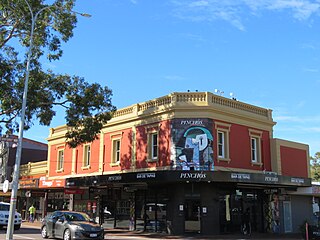
Subiaco is an inner-western suburb of Perth, the capital of Western Australia. It is approximately 3 km (1.9 mi) west of Perth's central business district, in the City of Subiaco local government area. Historically a working-class suburb containing a mixture of industrial and commercial land uses, since the 1990s the area has been one of Australia's most celebrated urban redevelopment projects. It remains a predominantly low-rise, urban village neighbourhood centred around Subiaco train station and Rokeby Road.

The City of Vincent is a local government area of Western Australia. It covers an area of approximately 10.4 square kilometres (4.0 sq mi) in metropolitan Perth, the capital of Western Australia, and lies about 3 km from the Perth CBD. The City of Vincent maintains 139 km of roads and 104 ha of parks and gardens. It had a population of over 33,000 at the 2016 Census.
The 1962 British Empire and Commonwealth Games were held in Perth, Western Australia, from 22 November to 1 December 1962. Athletic events were held at Perry Lakes Stadium in the suburb of Floreat and swimming events at Beatty Park in North Perth. It was held after the 1962 Commonwealth Paraplegic Games for wheelchair athletes.
Leederville is a suburb within the City of Vincent in the Perth metropolitan region of Western Australia.
The Mitchell Freeway is a 41.5-kilometre-long (25.8 mi) freeway in the northern suburbs of Perth, Western Australia, linking central Perth with the city of Joondalup. It is the northern section of State Route 2, which continues south as Kwinana Freeway and Forrest Highway. Along its length are interchanges with several major roads, including the Graham Farmer Freeway and Reid Highway. The southern terminus of the Mitchell Freeway is at the Narrows Bridge, which crosses the Swan River, and the northern terminus is at Romeo Road in Alkimos.

The Division of Perth is an Australian electoral division in the state of Western Australia. It is named after Perth, the capital city of Western Australia, where the Division is located.

West Leederville is a suburb 3 kilometres (1.9 mi) northwest of the central business district of Perth, the capital of Western Australia, and is within the Town of Cambridge. It used to be integrated with Leederville prior to the construction of the Mitchell Freeway through the suburb in 1972.
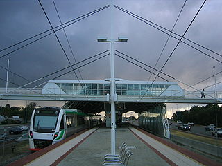
Leederville railway station is a suburban railway station on the boundary of Leederville and West Leederville, suburbs of Perth, Western Australia. The station is on the Yanchep line and is part of the Transperth network. Located within the median strip of the Mitchell Freeway, Leederville station consists of an island platform connected to either side of the freeway by a footbridge.
Wembley is a western suburb of Perth, Western Australia, located within the Town of Cambridge. Its postcode is 6014.

Lake Monger is a large urban wetland on the Swan Coastal Plain in suburban Perth, Western Australia nestled between the suburbs of Leederville, Wembley and Glendalough.

The electoral district of Perth is a Legislative Assembly electorate in the state of Western Australia. Perth is named for the capital city of Western Australia whose central business district falls within its borders. It is one of the oldest electorates in Western Australia, with its first member having been elected in the inaugural 1890 elections of the Legislative Assembly.

Leederville Oval is an Australian rules football ground located in Leederville, a suburb of Perth, Western Australia. The ground is used as a home ground by two clubs: the East Perth Football Club and the Subiaco Football Club, both competing in the West Australian Football League (WAFL). The ground was previously home to the West Perth Football Club from 1915 to 1993, before the club moved to Arena Joondalup, its current home ground. The ground is serviced by the Yanchep line, with the nearest stop being Leederville station.

The Perth tramway network served Perth, the capital city of Western Australia, from 1899 until 1958. The network was initially run by a private company but was taken over by the state government in 1913. From a single line along Hay Street, the network expanded north as far as Osborne Park, east as far as Welshpool, south as far as Como, and west as far as Claremont. The tramways were gradually replaced by buses after World War II.

The Perth Wetlands, also known as the Perth Great Lakes or the Great Lakes District, was a collection of fresh-water wetlands, swamps and lakes located on the Swan Coastal Plain north of the city of Perth in Western Australia. Over a period of 80 years from the first British settlement in Western Australia in 1829 most of the wetlands were reclaimed for use as housing, parks and market gardens.
Thomas Street is a major northeast-southwest road in the Perth suburbs of Subiaco and West Perth, connecting Winthrop Avenue with Loftus Street. These roads, together with London Street further north, form State Route 61, which links Crawley with West Perth and Yokine.
Loftus Street is a major north–south road in the Perth suburbs of Subiaco and West Perth, connecting London Street with Thomas Street. These roads, together with Winthrop Avenue further south, form State Route 61, which links Crawley with West Perth and Yokine.
Aberdeen Street is a street in the Perth suburbs of Perth and Northbridge that runs from a cul-de-sac west of Lord Street in the east to a cul-de-sac between Fitzgerald Street and the Mitchell Freeway in the west. The street has 42 locally listed places of significance, 18 of which are also listed on the State Register of Heritage Places.
